 | Los Padres National Forest is a United States national forest in southern and central California. Administered by the United States Forest Service, Los... 24 KB (2,290 words) - 02:20, 22 January 2024 |
 | located at 5225 Figueroa Mountain Road, Los Olivos, California, on the edge of Los Padres National Forest. From 1988 to 2005, it was the home and private... 36 KB (3,388 words) - 08:58, 19 April 2024 |
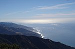
Big Sur land use (section National Forest Scenic Area) development. The majority of the interior region is part of the Los Padres National Forest, Ventana Wilderness, Silver Peak Wilderness or Fort Hunter Liggett... 72 KB (8,149 words) - 23:31, 5 March 2024 |
 | longest publicly accessible beaches on that coast. It is within the Los Padres National Forest. The beach is 3.7 miles (6.0 km) north of the small commercial... 2 KB (124 words) - 09:57, 17 February 2024 |
 | Yarnbombing. His installations exist for just 9 days typically in Los Padres National Forest. As part of his 2012 resolution to learn 12 new skills, Duneier... 19 KB (1,504 words) - 17:46, 5 January 2024 |
entire forest was transferred to Santa Barbara National Forest and the name was discontinued. The lands presently exist in Los Padres National Forest. Davis... 2 KB (153 words) - 00:33, 31 January 2024 |
 | Big Sur (category Monterey Ranger District, Los Padres National Forest) development. The majority of the interior region is part of the Los Padres National Forest, Ventana Wilderness, Silver Peak Wilderness or Fort Hunter Liggett... 193 KB (20,230 words) - 04:36, 11 April 2024 |
 | Hines Peak (category Los Padres National Forest) of Los Padres National Forest, several miles northeast of Santa Paula. Snow falls on the mountain during the winter months. Topatopa Mountains Los Padres... 2 KB (102 words) - 20:27, 1 March 2023 |
 | Chumash Wilderness (category Los Padres National Forest) 38,150 acres (15,440 ha) wilderness area within the southern Los Padres National Forest. It is located in the Transverse Ranges, in northern Ventura County... 5 KB (442 words) - 08:07, 20 June 2023 |
 | has been traded between the United States Forest Service, which owns the adjacent Los Padres National Forest, and the Army. Junipero Serra Peak is to the... 23 KB (2,069 words) - 23:48, 25 April 2024 |
Garcia Wilderness (category Los Padres National Forest) the Los Padres National Forest in San Luis Obispo County, California. The wilderness was created by the U.S. Congress as part of the Los Padres Condor... 3 KB (217 words) - 15:07, 17 April 2023 |
 | and even an observatory. Located near East Camino Cielo in the Los Padres National Forest, the ridge-top site has a panoramic view of Lake Cachuma and the... 2 KB (300 words) - 09:32, 19 April 2023 |
 | Emigdio Mountains, on the San Andreas fault. It is surrounded by Los Padres National Forest. The settlement lies between Apache Saddle and Pinon Pines Estates... 22 KB (2,122 words) - 14:32, 19 March 2024 |
 | primitive campsite and trail head into the Ventana Wilderness and the Los Padres National Forest. A locked gate provides access to a 3.3 miles (5.3 km) long private... 31 KB (3,150 words) - 21:38, 27 July 2023 |
 | California. It is located 6 miles north of the Ojai Valley, within Los Padres National Forest. It is named for Wheeler Blumberg, who founded the town in 1891... 14 KB (1,382 words) - 05:36, 29 January 2024 |
founding, they conducted an inventory of public lands within the Los Padres National Forest Monterey Ranger District. Their goal was to assess the suitability... 8 KB (863 words) - 01:44, 12 April 2024 |
 | Wolf Fire (category Los Padres National Forest) the fire impacted large parts of the Sespe Wilderness and the Los Padres National Forest, causing road and campground closures while threatening Native... 39 KB (3,390 words) - 18:44, 24 April 2024 |
 | Santa Lucia Range (category Monterey Ranger District, Los Padres National Forest) Serra Peak, 1,784 metres (5,853 ft) in Monterey County and the Los Padres National Forest. Junipero Serra Peak, 5,857 feet (1,785 m). Cone Peak, 5,158 feet... 20 KB (2,291 words) - 04:16, 2 April 2024 |
four national forests it applies to are the Angeles National Forest, Cleveland National Forest, Los Padres National Forest and San Bernardino National Forest... 8 KB (1,181 words) - 03:14, 9 April 2023 |
 | Tassajara Fire (category Monterey Ranger District, Los Padres National Forest) 1,086 acres (4 km2) of land in a rural, residential area near the Los Padres Forest, including 12 homes and numerous outbuildings. It was contained a... 2 KB (91 words) - 19:38, 27 March 2024 |
 | Lake Piru (category Los Padres National Forest) Lake Piru (/ˈpaɪruː/ ) is a reservoir located in Los Padres National Forest and Topatopa Mountains of Ventura County, California, created by the construction... 19 KB (1,786 words) - 21:17, 9 September 2023 |
 | intersection of Painted Cave road with East Camino Cielo Road in the Los Padres National Forest. Homer Snyder developed the ranch in 1902, and built the Laurel... 4 KB (355 words) - 09:28, 24 April 2024 |
 | three new designated Wild and Scenic Rivers in the Los Padres National Forest and Angeles National Forest in California. The law was sponsored by California... 9 KB (940 words) - 18:44, 28 April 2023 |
 | Sespe Condor Sanctuary (category Los Padres National Forest) It is within the Sespe Wilderness in the southern Los Padres National Forest. The United States Forest Service established the Sespe Condor Sanctuary in... 5 KB (372 words) - 20:33, 3 February 2022 |
 | the border between the Angeles National Forest and the Los Padres National Forest, in the northwestern portion of Los Angeles County. It is to the west... 8 KB (740 words) - 05:05, 15 February 2024 |
The unoccupied aircraft crashed into unpopulated scrubland in Los Padres National Forest near New Cuyama, and was substantially damaged. Jacob walked to... 21 KB (1,917 words) - 11:07, 19 April 2024 |
 | Angeles National Forest (ANF) of the U.S. Forest Service is located in the San Gabriel Mountains and Sierra Pelona Mountains, primarily within Los Angeles... 40 KB (3,782 words) - 02:26, 19 March 2024 |
 | Sespe Wilderness (category Los Padres National Forest) Topatopa Mountains and southern Sierra Pelona Mountains, within the Los Padres National Forest (LPNF), in Ventura County, Southern California. The wilderness... 4 KB (281 words) - 00:24, 1 November 2021 |
 | Pedicularis dudleyi (category Monterey Ranger District, Los Padres National Forest) Pedicularis dudleyi is a rare species of flowering plant in the family Orobanchaceae known by the common name Dudley's lousewort. It is endemic to central... 4 KB (412 words) - 17:50, 9 May 2023 |
 | boat. There are five miles of hiking trails within the park, and Los Padres National Forest trails close by. A large campsite on the south shore of Cachuma... 12 KB (1,266 words) - 05:22, 15 February 2024 |