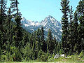
The Lubrecht State Experimental Forest is a 20,306-acre (8,218 ha) tract of protected land located in Missoula and Granite County, Montana, owned and managed... 4 KB (414 words) - 03:04, 9 February 2024 |
 | forest is in Missoula County, Montana, 46°53′30″N 113°26′03″W / 46.89167°N 113.43417°W / 46.89167; -113.43417 (Lubrecht State Experimental Forest)... 9 KB (1,434 words) - 10:11, 16 July 2023 |
 | (2009). Lubrecht State Experimental Forest Prescribed Fire Effects Study 1973-2006 (Report). Fort Collins, CO: U.S. Department of Agriculture, Forest Service... 15 KB (1,687 words) - 11:01, 29 January 2024 |
 | Bitterroot National Forest comprises 1.587 million acres (6,423 km2) in west-central Montana and eastern Idaho of the United States. It is located primarily... 11 KB (1,078 words) - 02:23, 9 January 2024 |
| the Custer-Gallatin goes along the state's southern border, with some of it a part of North-West Wyoming. The forest area comprises a total of 3,411,239... 11 KB (1,065 words) - 03:46, 28 November 2023 |
 | Montana (redirect from State of Montana) and state agencies administer approximately 31,300,000 acres (127,000 km2), or 35 percent of Montana's land. The U.S. Department of Agriculture Forest Service... 242 KB (23,193 words) - 03:21, 15 April 2024 |
 | Acreage by State, Congressional District, and County, 30 September 2008". "USFS Ranger Districts by State" (PDF). "Helena National Forest". U.S. Forest Service... 6 KB (490 words) - 23:30, 5 August 2023 |
 | southwestern area of the state. President Theodore Roosevelt named the two forests in 1908 and they were merged in 1996. Forest headquarters are located... 9 KB (811 words) - 20:28, 9 January 2024 |
 | The Flathead National Forest is a national forest in the western part of the U.S. state of Montana. The forest lies primarily in Flathead County, south... 8 KB (721 words) - 03:56, 7 December 2022 |
 | National Forest is a national forest located in western Montana, United States with the western boundary being the state of Idaho. The forest spans 2 million... 7 KB (545 words) - 01:28, 14 September 2023 |
and Clark National Forest is located in west central Montana, United States. Spanning 2,912 square miles (7,500 km2), the forest is managed as two separate... 15 KB (1,438 words) - 02:23, 9 January 2024 |
 | 2 million acres (8,900 km2) administered by the forest, less than 3 percent is located in the state of Idaho. Forest headquarters are located in Libby, Montana... 6 KB (502 words) - 14:15, 20 May 2023 |
 | Anaconda Smelter Stack (redirect from Anaconda Smoke Stack State Park) The stack and its viewing area are now the two-part Anaconda Smoke Stack State Park. The overall height of the stack is 585 feet 1+1⁄2 inches (178.35 m)... 16 KB (1,831 words) - 05:51, 1 August 2023 |
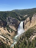 | Yellowstone National Park (section Forest fires) (March 11–13, 2003). "The State of Conservation of World Heritage Forests" (PDF). Proceedings of the 2nd World Heritage Forest Meeting. Archived (PDF) from... 168 KB (16,052 words) - 11:26, 19 April 2024 |
 | Bob Marshall Wilderness (category Lewis and Clark National Forest) Forest Service, Marshall was largely responsible for designation of large areas to be preserved as roadless within lands administered by the Forest Service;... 11 KB (977 words) - 01:28, 28 February 2023 |
Fish Creek State Park is a public recreation area covering 5,603 acres (2,267 ha) twelve miles west of Alberton, Montana. The state park is the second... 4 KB (253 words) - 22:14, 1 August 2023 |
 | Custer National Forest is located primarily in the south central part of the U.S. state of Montana but also has separate sections in northwestern South... 9 KB (815 words) - 03:45, 1 January 2024 |
 | Bannack, Montana (redirect from Bannack State Park) the town is a National Historic Landmark managed by the state of Montana as Bannack State Park. Founded in 1862 and named after the local Bannock natives... 16 KB (1,310 words) - 04:08, 22 November 2023 |
 | computer technology, and field stations: The 28,000-acre (110 km2) Lubrecht Experimental Forest The 3,500-acre (14 km2) Bandy Ranch Faculty and scientists in... 4 KB (259 words) - 03:01, 1 August 2023 |
 | Welcome Creek Wilderness (category Lolo National Forest) is located in the U.S. state of Montana. Created by an act of Congress in 1978, the wilderness is within Lolo National Forest, and protects the northern... 4 KB (316 words) - 02:50, 24 December 2021 |
 | Lewis and Clark Caverns (redirect from Lewis and Clark Caverns State Park) Lewis and Clark Caverns State Park is a 3,000-acre (1,200 ha) public recreation and nature preservation area located twelve miles (19 km) east of Whitehall... 12 KB (1,084 words) - 05:48, 2 August 2023 |
 | Medicine Rocks State Park is a park owned by the state of Montana in the United States. It is located about 25 miles (40 km) west-southwest of Baker,... 18 KB (2,080 words) - 05:56, 2 August 2023 |
 | Fort Owen State Park is a historic preservation area owned by the state of Montana in the United States, located on the northern outskirts of the town... 11 KB (1,176 words) - 19:15, 22 November 2023 |
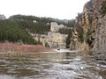
 | Milltown State Park is a public recreation area located at the confluence of the Clark Fork River and the Blackfoot River in Missoula County, Montana... 3 KB (130 words) - 05:57, 2 August 2023 |
Clearwater State Forest is a state forest located in Montana. The forest has an area of approximately 18,076 acres and is one of the seven state forests in Montana... 2 KB (182 words) - 21:16, 31 March 2024 |
 | Wild Horse Island (redirect from Wild Horse Island State Park) while grasslands cover the southeast. The northern side of the island has forests of Ponderosa pine and Douglas fir trees. The highest point is at 3,749... 10 KB (985 words) - 02:11, 2 December 2023 |
 | Makoshika State Park ("ma-KO-sh(ih)kuh" from the Lakota Mako sica, meaning 'bad land' or 'land that is bad') is a nature preserve and public recreation... 6 KB (493 words) - 14:19, 18 November 2023 |
 | Selway–Bitterroot Wilderness (category Bitterroot National Forest) parts of Bitterroot National Forest, Clearwater National Forest, Lolo National Forest, and the Nez Perce National Forest. The Frank Church-River of No... 4 KB (329 words) - 05:14, 6 September 2023 |
 | PMID 27618004. Kunkel, Günther (1984). Plants for Human Consumption. Lubrecht & Cramer Ltd. ISBN 978-3874292160. Kavasch, E. Barrie (12 June 1979). Native... 25 KB (2,461 words) - 19:32, 4 January 2024 |
 | U.S. Forest Service (USFS) owned some of the shoreline, these federal agencies were not very responsive to local demands for access. The state of Montana... 98 KB (13,570 words) - 21:19, 14 August 2023 |