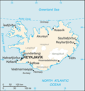
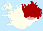
 | Múlaþing (Icelandic pronunciation: [ˈmuːlaˌθiŋk]) is a municipality in eastern Iceland which was formed in 2020 from the merger of Fljótsdalshérað, Seyðisfjörður... 3 KB (125 words) - 17:28, 24 November 2023 |
 | the border between the municipalities of Múlaþing and Fljótsdalshreppur so the western slopes are in Múlaþing and the eastern in Fljótsdalshreppur. It... 10 KB (902 words) - 10:43, 20 April 2024 |
 | on the banks of the Lagarfljót river. It is part of the municipality of Múlaþing and the largest settlement of the Eastern Region with, as of 2020, a population... 15 KB (1,065 words) - 03:32, 28 February 2024 |
 | is a ravine in Jökuldalur [is] [ˈjœːkʏlˌtaːlʏr̥] in the municipality of Múlaþing, in the Eastern Region of Iceland. It is known for its columnar basalt... 2 KB (186 words) - 21:48, 13 February 2024 |
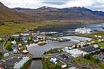 | the fjord of the same name. The town is located in the municipality of Múlaþing. A road over Fjarðarheiði mountain pass (elevation 600 m or 2,000 ft) connects... 16 KB (1,330 words) - 23:12, 15 November 2023 |
 | Fellabær 403 395 2% Múlaþing Austurland 50 Hellissandur 389 365 6.2% Snæfellsbær Vesturland 51 Djúpivogur 348 357 2.6% Múlaþing Austurland 52 Þórshöfn... 19 KB (301 words) - 07:56, 29 June 2023 |
 | coastal hamlet in eastern Iceland. It is a part of the municipality of Múlaþing and situated on the coast of the Borgarfjörður Eystri. Bakkagerði was declared... 10 KB (717 words) - 05:23, 23 September 2023 |
 | Fljótsdalshérað and Seyðisfjarðarkaupstaður to form the new municipality of Múlaþing. Djúpivogur features a cold tundra climate (Köppen: ET). Approximately... 11 KB (715 words) - 06:58, 5 February 2024 |
 | [ˈfljoutsˌtalsˌçɛːraθ] ) was a municipality located in eastern Iceland. In 2020 it merged with three neighbouring municipalities to form Múlaþing. v t e... 2 KB (25 words) - 01:37, 28 October 2023 |
 | 74722°W / 65.09333; -14.74722 Country Iceland County Norður-Múlasýsla Municipality Múlaþing Area • Total 7.4 km2 (2.9 sq mi) Elevation 65 m (213 ft)... 9 KB (1,003 words) - 21:04, 16 April 2023 |
0 Vestmannaeyjabær Brimilsnes, in Álftafjörður in the Eastfjords 0.6 0 Múlaþing Brokey, the largest of many islands in Breiðafjörður (West), located a... 11 KB (248 words) - 07:58, 20 December 2023 |
jurisdiction: Vopnafjarðarhreppur, Sveitarfélagið Hornafjörður, Fljótsdalshreppur, Múlaþing, Fjarðabyggð. 7 Southern Region Hvolsvöllur Selfoss, Vík, Kirkjubæjarklaustur... 30 KB (2,206 words) - 12:56, 20 April 2024 |
Langanesbyggð Langanes Settlement 6 IS-MOS Mosfellsbær Mosfell Town 1 IS-MUL Múlaþing Mulathing 7 IS-MYR Mýrdalshreppur Myrdalur District 8 IS-NOR Norðurþing Nordurthing... 9 KB (180 words) - 08:20, 21 March 2024 |
 | Djúpavogshreppur, Fljótsdalshérað, and Seyðisfjarðarkaupstaður merged to form Múlaþing. 24 January 2019 Akureyrarkaupstaður renamed into Akureyrarbær. 7 January... 26 KB (1,556 words) - 22:25, 20 March 2024 |
 | mandatory basic education services through a cooperation agreement with Múlaþing. Health care services and other support services such as banks, post office... 32 KB (4,770 words) - 08:53, 10 March 2024 |
 | 884361°W / 65.37417; -15.884361 Country Iceland Constituency Northeast Constituency Region Eastern Region Municipality Múlaþing Elevation 469 m (1,539 ft)... 3 KB (168 words) - 01:08, 15 April 2023 |
Location Stadium 2023 season Haukar Hafnarfjörður Ásvellir 7th Höttur/Huginn Múlaþing Vilhjálmsvöllur 6th KF Fjallabyggð Ólafsfjarðarvöllur 10th KFA Fjarðabyggð... 9 KB (378 words) - 18:09, 21 October 2023 |
 | "Egilsstaðir". east.is. Retrieved 16 August 2022. "Landsbyggðastrætó / Strætó". Múlaþing. Retrieved 16 August 2022. "Fellabær". Olís. Retrieved 19 March 2017. v... 4 KB (95 words) - 10:09, 15 September 2022 |
(6,014 ft)) viewed from Kárahnjúkar. The tallest stratovolcano in Iceland is located in the Vatnajökull National Park. (See Snæfell (Múlaþing) index)... 216 KB (16,712 words) - 23:23, 21 April 2024 |
Dalvík/Reynir Dalvík Dalvíkurvöllur Haukar Hafnarfjörður Ásvellir Höttur/Huginn Múlaþing Vilhjálmsvöllur ÍR Reykjavík (Breiðholt) ÍR-völlur KF Fjallabyggð Ólafsfjarðarvöllur... 10 KB (180 words) - 12:37, 27 October 2023 |
1963: 47.7MW 290,104 1953 [citation needed] [citation needed]Lagarfoss Múlaþing 65°30′25″N 14°21′56″W / 65.50694°N 14.36556°W / 65.50694; -14.36556... 13 KB (352 words) - 18:31, 18 February 2024 |
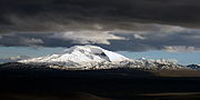
Snæfell may refer to: Snæfell (Múlaþing), a mountain (1,833 m) north-east of Vatnajökull, in the eastern region of Iceland (usual use unqualified) Snæfellsjökull... 690 bytes (111 words) - 01:27, 10 March 2024 |
 | Fljótsdalshérað, and Seyðisfjarðarkaupstaður to form the municipality of Múlaþing. Its main settlement is Bakkagerði. It is located in the Austurland region... 3 KB (160 words) - 23:41, 28 December 2023 |
 | Hallgrimsson, Helgi (2006), "Stafkirkja og rauðviðarskáli á Valþjófsstað.", Múlaþing, 33: 123–141 Harris, Richard L. (1970), "The Lion-Knight Legend in Iceland... 10 KB (1,168 words) - 03:12, 23 January 2024 |
 | Fjarðabyggð Fljótsdalshreppur Grýtubakkahreppur Hörgársveit Langanesbyggð Múlaþing Norðurþing Skútustaðahreppur Svalbarðshreppur Svalbarðsstrandarhreppur... 92 KB (3,070 words) - 19:45, 5 March 2024 |