 | The Malheur Indian Reservation was an American Indian reservation established for the Northern Paiute in eastern Oregon and northern Nevada from 1872... 11 KB (1,244 words) - 23:01, 11 April 2024 |
 | Indian Reservation, formed in 1856, a much smaller remnant exists as the Siletz Reservation Malheur Indian Reservation Table Rock Indian Reservation Federally... 4 KB (395 words) - 16:29, 9 June 2022 |
 | restricted to living in the Malheur Indian Reservation. After it was established, the size of the Malheur Indian Reservation continued to shrink as small... 34 KB (3,619 words) - 02:35, 25 September 2023 |
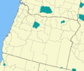
 | City of Burns; this 760-acres reservation of the Burns Paiute Tribe is a remnant of the former Malheur Indian Reservation. Harney County has a "high desert"... 35 KB (3,403 words) - 18:41, 26 April 2024 |
 | This is a list of Indian reservations and Indian colonies in the U.S. state of Nevada. Indigenous peoples of the Great Basin List of federally recognized... 6 KB (88 words) - 15:36, 22 February 2023 |
 | Samuel B. Parrish (category United States Indian agents) He worked for Indian Affairs during the Modoc Wars, was instrumental in establishing the Malheur Indian Reservation, and was an Indian Agent there. With... 15 KB (1,798 words) - 03:41, 6 April 2024 |
 | William V. Rinehart (category American people of the Indian Wars) during the American Civil War. He was later appointed as Indian agent at the Malheur Indian Reservation in eastern Oregon. Rinehart then moved to Seattle, Washington... 16 KB (1,653 words) - 07:28, 27 April 2024 |
V W X Y Z Machesaw Indian Reservation (IN)—disestablished Malheur Indian Reservation (OR)—disestablished Mazaqua Indian Reservation (IN)—disestablished... 16 KB (2,323 words) - 06:45, 2 July 2022 |
 | Retrieved April 8, 2013. Jenks 2013, pp. 34–37. Allen, Cain (2005). "Malheur Indian Reservation". The Oregon History Project. Oregon Historical Society. Archived... 42 KB (3,833 words) - 22:51, 10 March 2024 |
 | Western Shoshone peoples, whose reservation Fort McDermitt Paiute and Shoshone Tribes of the Fort McDermitt Indian Reservation spans the Nevada and Oregon... 11 KB (1,151 words) - 17:48, 11 April 2024 |
purpose of the Schedule of Indian Land Cessions was to indicate the location of each cession by or reservation for the Indian Tribes. Royce's column headings... 117 KB (4,660 words) - 19:09, 19 April 2024 |
 | onto the Malheur Reservation as Rinehart insisted and conditions continued to worsen. Two Shoshone "Dog Soldiers" came to the Malheur Reservation in March... 14 KB (1,614 words) - 20:39, 15 January 2024 |
Burns Paiute Tribe (redirect from Burns Paiute Indian Reservation) controlled about 52,500 square miles (136,000 km2) along the shores of Malheur Lake, between the Cascade Range in central Oregon and the Payette Valley... 10 KB (1,036 words) - 22:50, 7 March 2024 |
 | McDermitt, Nevada and Oregon (category Unincorporated communities in Malheur County, Oregon) community straddling the Nevada–Oregon border, in Humboldt County, Nevada, and Malheur County, Oregon, United States. McDermitt's economy has historically been... 23 KB (1,501 words) - 22:31, 10 March 2024 |
 | Sarah Winnemucca (category People from Malheur County, Oregon) the Bureau of Indian Affairs at Fort McDermitt as an interpreter, and later was invited to interpret at the Malheur Reservation by Indian Agent Samuel... 32 KB (3,941 words) - 02:34, 28 March 2024 |
 | resettled on the Yakama Indian Reservation in the Washington Territory, 350 miles (560 km) north of the Malheur reservation. The Army officially changed... 12 KB (1,416 words) - 23:17, 25 April 2024 |
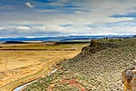
 | Harney Basin (redirect from Harney-Malheur) caused President Ulysses S. Grant in 1872 to create a reservation for the Paiute encompassing Malheur Lake and much of the basin. Growing settlement pressures... 12 KB (1,285 words) - 23:23, 2 April 2023 |
 | Subsequent clashes between the two cultures led to creation of the Malheur Indian Reservation, which included the Drewsey area, in 1872. There the Paiutes and... 14 KB (790 words) - 09:39, 14 February 2024 |
Bannock War (category Indian wars of the American Old West) about 543 Bannock and Paiute prisoners from the Malheur Reservation to internment at Yakama Indian Reservation in southeastern Washington Territory. They suffered... 21 KB (2,845 words) - 22:41, 11 April 2024 |
 | Northern Shoshone (section Tribes and reservations) whom resisted placement on the Malheur Reservation, finally settled at Fort Hall and on the Duck Valley Indian Reservation, a mixed Shoshone-Northern Paiute... 12 KB (1,416 words) - 18:48, 6 May 2023 |
 | Paiute population. The settlers won the war and then set aside the Malheur Reservation for the Northern Paiute and other Oregon Native American tribes.... 38 KB (3,673 words) - 05:51, 3 March 2024 |
 | Northern Paiute people (redirect from Northern Paiute Indians) account of this period. The US government first established the Malheur Reservation for the Northern Paiute in eastern Oregon. It intended to concentrate... 30 KB (3,999 words) - 10:01, 3 May 2024 |
became known as the Bannock War, Malheur Reservation Indian agent William V. Rinehart reported to the Commissioner of Indian Affairs that Wahweveh, with 55... 3 KB (438 words) - 22:33, 27 November 2021 |
 | Southern Paiute people (redirect from Digger Indian) Las Vegas Indian Colony—Las Vegas, Nevada Moapa Band of Paiute Indians of the Moapa River Indian Reservation—Moapa River Indian Reservation, Moapa, Nevada... 31 KB (3,293 words) - 02:43, 19 April 2024 |
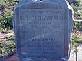 | Jean Baptiste Charbonneau (category Wind River Indian Reservation) to Malheur County by the landowners for historic preservation, and features three historical markers within walking distance: In 1971, the Malheur County... 34 KB (4,387 words) - 23:10, 11 April 2024 |
 | Humboldt County, Nevada (section Reservations) by Indian reservations. The Fort McDermitt Indian Reservation spans the distance of the Nevada–Oregon border, in Humboldt County, Nevada and Malheur County... 23 KB (3,087 words) - 21:52, 27 April 2024 |
 | Duck Valley Indian Reservation Jackpot West Wendover New Mexico North Dakota Southwestern Oklahoma Kenton Oregon Northern 4⁄5 of Malheur County South... 22 KB (1,855 words) - 08:49, 15 January 2024 |
 | Blue Mountains (Pacific Northwest) (category Malheur National Forest) and the Confederated Tribes of the Umatilla Indian Reservation. Much of the range is included in the Malheur National Forest, Umatilla National Forest,... 15 KB (1,444 words) - 21:55, 3 April 2024 |
 | Owyhee River (category Rivers of Malheur County, Oregon) springs near the eastern boundary of the Fort McDermitt Indian Reservation in southern Malheur County. It flows generally northeast to meet the larger... 20 KB (2,024 words) - 02:35, 16 January 2023 |
Lake Fork West Owyhee River (category Rivers of Malheur County, Oregon) springs near the eastern boundary of the Fort McDermitt Indian Reservation in southern Malheur County. It flows generally northeast to meet the larger... 4 KB (153 words) - 13:44, 2 June 2023 |