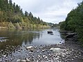
 | The Malheur River (local pronunciation: "MAL-hyure") is a 190-mile-long (306 km) tributary of the Snake River in eastern Oregon in the United States.... 10 KB (888 words) - 09:09, 19 October 2023 |
 | was named after the Malheur River, which runs through the county. The word "malheur" is French for misfortune or tragedy. Malheur County is included in... 28 KB (2,464 words) - 18:43, 26 April 2024 |
 | President Theodore Roosevelt on June 13, 1908, and is named after the Malheur River, from the French, meaning "misfortune". It is managed by the United... 10 KB (540 words) - 09:20, 19 October 2023 |
 | The Malheur Indian Reservation was an American Indian reservation established for the Northern Paiute in eastern Oregon and northern Nevada from 1872... 11 KB (1,244 words) - 23:01, 11 April 2024 |
 | quick succession – the Boise River from the right, the Owyhee and Malheur Rivers from the left, the Payette and Weiser Rivers from the right near Ontario... 153 KB (16,133 words) - 22:29, 28 April 2024 |
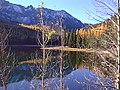
The Little Malheur River is a 31-mile (50 km) tributary of the North Fork Malheur River in the eastern part of the U.S. state of Oregon. Beginning on the... 5 KB (220 words) - 09:37, 10 May 2020 |
Malheur may refer to: Malheur County, Oregon Malheur Lake Malheur River Malheur Butte Malheur National Wildlife Refuge Occupation of the Malheur National... 360 bytes (68 words) - 21:24, 27 April 2022 |
 | Malheur National Wildlife Refuge is a National Wildlife Refuge located roughly 30 miles (48 km) south of the city of Burns in Oregon's Harney Basin. Administered... 34 KB (3,619 words) - 02:35, 25 September 2023 |
 | Harney Basin (redirect from Harney-Malheur) 765 sq mi (1,980 km2) discharges into Malheur Lake and includes the river portion of the 292 sq mi (760 km2) Malheur National Wildlife Refuge. "Alkali Field... 12 KB (1,285 words) - 23:23, 2 April 2023 |
The South Fork Malheur River is a tributary of the Malheur River in a sparsely populated part of the U.S. state of Oregon. Arising southeast of the unincorporated... 4 KB (210 words) - 16:51, 25 November 2023 |
 | lake is marsh fed by the Donner und Blitzen River from the south and the Silvies River from the north. Malheur Lake periodically overflows into Mud Lake... 9 KB (899 words) - 18:20, 2 June 2022 |
 | group of far-right extremists seized and occupied the headquarters of the Malheur National Wildlife Refuge in Harney County, Oregon, and continued to occupy... 187 KB (17,956 words) - 03:53, 21 April 2024 |
Willow Creek is a 57-mile (92 km) tributary of the Malheur River in Malheur County in the U.S. state of Oregon. The creek, which forms at 3,724 feet (1... 6 KB (472 words) - 02:44, 12 May 2020 |
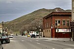 | Vale, Oregon (category Cities in Malheur County, Oregon) intersection of U.S. Routes 20 and 26, on the Malheur River at its confluence with Bully Creek. Vale was selected as Malheur's county seat in 1888 in a vote where... 17 KB (1,294 words) - 01:33, 15 November 2023 |
 | 2015. National Performance of Dams Program (2016). "Antelope Reservoir (Malheur)". Archived from the original on March 13, 2016. Retrieved March 12, 2016... 145 KB (5,874 words) - 15:30, 2 March 2024 |
 | Yaquina River Long Tom River Lookingglass Creek Lost River Lostine River Luckiamute River Malheur River Marys River McKenzie River Metolius River Metolius... 97 KB (11,400 words) - 07:31, 5 March 2024 |
 | Malheur Butte is an extinct volcano located in Malheur County, Oregon. Between 20 and 15 million years ago, the region from north-central Washington to... 3 KB (286 words) - 09:33, 4 May 2023 |
 | List of longest streams of Oregon (redirect from List of longest rivers of Oregon) the ocean. Other streams like the Donner und Blitzen River flow into closed basins, such as Malheur Lake, that have no outlet to the sea. Source data for... 91 KB (4,311 words) - 21:57, 30 December 2023 |
 | flood. The Malheur/Harney lake system in Oregon is normally cut off from drainage to the ocean, but has an outflow channel to the Malheur River. This is... 33 KB (3,767 words) - 09:54, 30 April 2024 |
 | is now Malheur Lake, Oregon was created when a lava flow dammed the Malheur River. Among all lake types, volcanic crater lakes most closely approximate... 81 KB (9,632 words) - 15:54, 18 April 2024 |
 | Juntura, Oregon (category Unincorporated communities in Malheur County, Oregon) was named for its proximity to the confluence of the Malheur River with the North Fork Malheur River. The name was probably selected by local settler B... 9 KB (724 words) - 22:36, 29 March 2024 |
buried Malheur Lake in Harney County Mann Lake in Harney County Odell Lake at sunrise Owyhee Reservoir, a long and narrow reservoir on the Owyhee River Siltcoos... 21 KB (209 words) - 09:08, 26 August 2023 |
The North Fork Malheur River is a 59-mile (95 km) tributary of the Malheur River in eastern Oregon in the United States. Rising in Big Cow Burn in the... 12 KB (1,089 words) - 06:53, 22 April 2021 |
 | from Harney to Burns, ended with Burns as the county seat in 1890. The Malheur River Indian Reservation was created by executive order on March 14, 1871... 35 KB (3,403 words) - 18:41, 26 April 2024 |
 | in the U.S. state of Oregon. Drewsey is along the main stem of the Malheur River, about 45 miles (72 km) east of Burns, off U.S. Route 20. It has the... 14 KB (790 words) - 09:39, 14 February 2024 |
Meek Cutoff (category Transportation in Malheur County, Oregon) the Malheur River to head into the Harney Basin. They then turned west towards Wagontire Mountain and northwest to the south fork of the Crooked River. At... 17 KB (2,439 words) - 19:52, 12 April 2024 |
Bully, Seine-Maritime, France Bully-les-Mines, France Bully Creek (Malheur River tributary), Oregon, US Bully (mascot), mascot of the Mississippi State... 4 KB (461 words) - 17:38, 3 December 2023 |
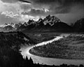
 | Oregon Trail (category Columbia River Gorge) Snake River ford near Old Fort Boise the weary travelers traveled across what would become the state of Oregon. The trail then went to the Malheur River and... 143 KB (19,100 words) - 00:12, 24 April 2024 |
United States, inhabiting the Harney Basin, and the Snake River basin, including Malheur River in Oregon and Idaho. It reaches a maximum length of 13.0 cm... 1 KB (98 words) - 14:02, 12 August 2023 |
 | the Powder River and downstream of the Malheur River, slightly more than 327 miles (526 km) from the Snake's confluence with the Columbia River. Draining... 6 KB (355 words) - 20:18, 16 November 2023 |