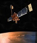
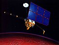
 | Mars Global Surveyor (MGS) was an American robotic space probe developed by NASA's Jet Propulsion Laboratory and launched November 1996. MGS was a global... 41 KB (4,433 words) - 10:04, 9 March 2024 |
 | Mars Surveyor '98 was a mission in NASA's Mars Exploration Program that launched the Mars Climate Orbiter and the Mars Polar Lander to the planet Mars... 4 KB (431 words) - 16:54, 8 January 2021 |
Mars Surveyor may refer to various NASA Mars probes: Mars Global Surveyor, single orbiter launched in 1996 Mars Surveyor 1998, where NASA lost both probes:... 538 bytes (108 words) - 09:41, 6 April 2020 |
 | (2016) Following the 1993 failure of the Mars Observer orbiter, the NASA Mars Global Surveyor achieved Mars orbit in 1997. This mission was a complete... 120 KB (11,215 words) - 18:19, 24 April 2024 |
 | from Mars Global Surveyor (MGS), Mars Odyssey and Mars Reconnaissance Orbiter (MRO), as well as the MOLA topography model and provides a global resolution... 53 KB (6,204 words) - 23:48, 18 March 2024 |
 | visited Mars and made new observations of the Cydonia region. These spacecraft have included NASA's Mars Global Surveyor (1997–2006) and Mars Reconnaissance... 24 KB (2,296 words) - 23:11, 17 March 2024 |
 | 2002 2001 Mars Odyssey · Mars Mars Odyssey as imaged by Mars Global Surveyor MARIE hardware, designed to measure radiation By 2008, Mars Odyssey had... 29 KB (2,535 words) - 16:35, 25 April 2024 |
 | Mars Global Surveyor (MGS) was developed by NASA's Jet Propulsion Laboratory and launched November 1996. It began the United States' return to Mars after... 95 KB (8,984 words) - 05:41, 26 April 2024 |
| The Mars Climate Orbiter (formerly the Mars Surveyor '98 Orbiter) was a robotic space probe launched by NASA on December 11, 1998, to study the Martian... 25 KB (2,466 words) - 08:04, 20 February 2024 |
 | of Mars icecaps. Mars Global Surveyor MOC2-1151 Release Global warming on Mars? Images of melting ice cap: Evidence for Recent Climate Change on Mars... 113 KB (11,729 words) - 23:08, 19 April 2024 |
The satellites of Mars include : Non functional but (probably) orbiting: Viking 1 & 2 orbiter Mariner 9 Mars Global Surveyor Mars 2, 3, 5 Phobos 2 Tianwen... 1 KB (95 words) - 00:30, 8 March 2024 |
 | planet's surface. Mars Global Surveyor is expected to crash onto the surface of the planet by 2047. The fate of the Soviet's three Mars program orbiters... 14 KB (1,107 words) - 05:15, 28 December 2023 |
 | while entering Mars's atmosphere. Out of 5–6 NASA missions in the 1990s, only 2 worked: Mars Pathfinder and Mars Global Surveyor, making Mars Pathfinder and... 33 KB (3,596 words) - 14:55, 13 April 2024 |
 | solar system portal astronomy portal Caves of Mars Project Cydonia (Mars) Libya Montes Mars Global Surveyor Mars monolith Monolith (Space Odyssey) Science... 7 KB (588 words) - 14:06, 13 April 2024 |
 | outer layer. Both Mars Global Surveyor and Mars Express have detected ionised atmospheric particles trailing off into space behind Mars, and this atmospheric... 208 KB (18,892 words) - 22:45, 26 April 2024 |
 | Valles Marineris (redirect from Mars rift) Noctis Labyrinthus taken with Mars Global Surveyor. Layers in the wall of Noctis Labyrinthus taken with Mars Global Surveyor, under the MOC Public Targeting... 25 KB (2,927 words) - 10:36, 22 March 2024 |
 | The Mars Orbiter Laser Altimeter (MOLA) was one of five instruments on the Mars Global Surveyor (MGS) spacecraft, which operated in Mars orbit from September... 4 KB (484 words) - 20:25, 13 November 2023 |
 | Release No. MOC2-481 via the Mars Global Surveyor. Elysium Mons: Malin Space Science Systems via the Mars Global Surveyor. Mars features database distributed... 15 KB (442 words) - 22:29, 12 April 2024 |
 | The Mars Polar Lander, also known as the Mars Surveyor '98 Lander, was a 290-kilogram robotic spacecraft lander launched by NASA on January 3, 1999, to... 47 KB (3,522 words) - 22:11, 30 December 2023 |
shadow were taken with the arrival in 1997 of the Mars Global Surveyor and its high-resolution Mars Orbital Camera. One such image was taken on 26 August... 22 KB (1,945 words) - 04:25, 11 April 2024 |
 | Areography (redirect from Topography of Mars) were dispelled. Some maps of Mars were made using the data from these missions, but it wasn't until the Mars Global Surveyor mission, launched in 1996 and... 26 KB (3,155 words) - 14:22, 26 January 2024 |
 | important events Mars Global Surveyor § Discovery of water ice on Mars Martian canals – Erroneous idea of canals on Mars Mud cracks on Mars Torbet, Georgina... 265 KB (28,728 words) - 04:41, 15 April 2024 |
 | Malin Space Science Systems (category Missions to Mars) for Mars Global Surveyor. They also developed the cameras that were carried on Mars Polar Lander, Mars Climate Orbiter, 2001 Mars Odyssey, Mars Reconnaissance... 12 KB (1,369 words) - 22:34, 8 April 2023 |
 | objectives: Mars Global Surveyor launched in 1996, Mars Climate Orbiter launched in 1998, 2001 Mars Odyssey launched in 2001 and Mars Reconnaissance Orbiter... 39 KB (2,306 words) - 22:10, 30 December 2023 |
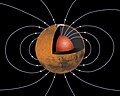 | field measurements from the Mars Global Surveyor (MGS) magnetic field experiment/electron reflectometer (MAG/ER) and Mars Atmosphere and Volatile Evolution... 22 KB (2,142 words) - 16:53, 14 April 2024 |
 | radio frequency signal. December Following the loss of NASA's Mars Global Surveyor (MGS), Mars Express team was requested to perform actions in the hopes... 58 KB (6,302 words) - 01:58, 6 February 2024 |
 | to lack of funding Mars Surveyor 2001 Lander – October 2001 – Mars lander (refurbished, became Phoenix lander) Kitty Hawk – Mars airplane micromission... 64 KB (3,240 words) - 07:01, 27 April 2024 |
 | Hellas Planitia (category Impact craters on Mars) Hellas basin during northern summer." "Martian weather observation". Mars Global Surveyor. Palo Alto, California: Stanford University. Archived from the original... 18 KB (1,820 words) - 00:28, 26 January 2024 |
 | separately discovered on images acquired by the MOC camera on board the Mars Global Surveyor during 1998–1999. At first it was generally thought they were unrelated... 39 KB (4,425 words) - 04:57, 6 January 2024 |
 | but later that day missed another communications session with the Mars Global Surveyor. The next day, JPL received a beep from the rover, indicating that... 80 KB (9,727 words) - 20:10, 23 April 2024 |