Massachusetts Avenue (colloquially referred to as Mass Ave) is a major thoroughfare in Boston, Massachusetts, and several cities and towns northwest of... 13 KB (1,007 words) - 13:14, 30 March 2024 |
 | KML/Commonwealth Avenue (Boston) KML is from Wikidata Commonwealth Avenue (colloquially referred to as Comm Ave) is a major street in the cities of Boston and Newton... 14 KB (1,207 words) - 00:44, 19 October 2023 |
 | Boston (US: /ˈbɔːstən/), officially the City of Boston, is the capital and most populous city in the Commonwealth of Massachusetts in the United States... 228 KB (19,455 words) - 23:46, 10 May 2024 |
 | Allston (redirect from Allston, Boston, Massachusetts) Allston is an officially recognized neighborhood within the City of Boston, Massachusetts, United States. It was named after the American painter and poet... 37 KB (3,545 words) - 23:33, 29 April 2024 |
 | Dorchester Avenue (sometimes called Dot Ave) is a street in Boston, Massachusetts, running from downtown south via South Boston and Dorchester to the border... 9 KB (942 words) - 03:24, 26 March 2024 |
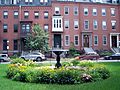
 | Back Bay is an officially recognized neighborhood of Boston, Massachusetts, built on reclaimed land in the Charles River basin. Construction began in... 35 KB (3,040 words) - 18:55, 10 May 2024 |
 | neighborhood comprising more than 6 square miles (16 km2) in the City of Boston, Massachusetts, United States. Originally, Dorchester was a separate town, founded... 120 KB (10,638 words) - 19:12, 7 April 2024 |
 | Huntington Avenue is a thoroughfare in the city of Boston, Massachusetts, beginning at Copley Square and continuing west through the Back Bay, Fenway... 10 KB (858 words) - 03:55, 25 March 2024 |
 | through the MetroWest suburbs of Boston, parallel to the Massachusetts Turnpike. Crossing the Route 128 freeway circling Boston, it passes through the inner... 23 KB (1,128 words) - 23:58, 11 May 2024 |
 | Atlantic Avenue is a street in downtown Boston, Massachusetts, partly serving as a frontage road for the underground Central Artery (I-93) and partly running... 8 KB (944 words) - 12:19, 19 April 2024 |
 | The South End is a neighborhood in Boston, Massachusetts, United States which is bordered by Back Bay, Chinatown, and Roxbury. It is distinguished from... 37 KB (3,923 words) - 13:39, 28 April 2024 |
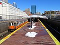 | Massachusetts Avenue station is a rapid transit station in the South End and Symphony neighborhoods of Boston, Massachusetts. It serves the MBTA Orange... 15 KB (1,362 words) - 22:46, 24 March 2024 |
The University of Massachusetts Boston (stylized as UMass Boston) is a public research university in Boston, Massachusetts, United States. It is the only... 184 KB (17,655 words) - 17:32, 25 April 2024 |
 | Square/Boston Public Library Commonwealth Avenue Mall Newbury Street Bay Village (also known as South Cove) Beacon Hill Louisburg Square Massachusetts State... 19 KB (1,622 words) - 16:57, 29 April 2024 |
 | Silver Line (MBTA) (redirect from Silver Line (Boston)) The Silver Line is a system of bus routes in Boston and Chelsea, Massachusetts, operated by the Massachusetts Bay Transportation Authority (MBTA). It is... 111 KB (11,039 words) - 18:24, 22 April 2024 |
 | Newbury Street (redirect from Newbury Street, Boston) Back Bay area of Boston, Massachusetts, in the United States. It runs roughly east–west, from the Boston Public Garden to Brookline Avenue. The road crosses... 18 KB (1,999 words) - 00:53, 26 March 2024 |
Massachusetts Avenue may refer to: Massachusetts Avenue (metropolitan Boston), Massachusetts Massachusetts Avenue (MBTA Orange Line station), a subway... 1 KB (166 words) - 14:25, 24 August 2022 |
 | South Station (redirect from Boston South (Amtrak station)) Greater Boston and New England's second-largest transportation center after Logan International Airport. Located at the intersection of Atlantic Avenue and... 38 KB (3,719 words) - 17:46, 20 April 2024 |
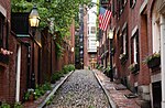
 | State House, is a historic building in Boston, Massachusetts, built in 1713. It was the seat of the Massachusetts General Court until 1798. It is located... 20 KB (2,097 words) - 02:45, 21 April 2024 |
 | The Boston Post Road was a system of mail-delivery routes between New York City and Boston, Massachusetts, that evolved into one of the first major highways... 33 KB (3,745 words) - 21:24, 12 December 2023 |
 | within the City of Boston, Massachusetts, United States. Roxbury is a dissolved municipality and one of 23 official neighborhoods of Boston used by the city... 91 KB (10,169 words) - 13:42, 20 April 2024 |
 | cities of Boston, Chelsea, Revere, and Winthrop. The traditional county seat is Boston, the state capital and the largest city in Massachusetts. The county... 31 KB (1,960 words) - 17:18, 25 April 2024 |
 | Boston Harbor is a natural harbor and estuary of Massachusetts Bay, and is located adjacent to the city of Boston, Massachusetts. It is home to the Port... 24 KB (2,638 words) - 14:10, 6 February 2024 |
 | Back Bay station (redirect from Boston Back Bay (Amtrak station)) is an intermodal passenger station in Boston, Massachusetts. It is located just south of Copley Square in Boston's Back Bay and South End neighborhoods... 28 KB (2,495 words) - 03:50, 28 March 2024 |
 | Fenway–Kenmore (redirect from Fenway-Kenmore, Boston, Massachusetts) Fenway–Kenmore is an officially recognized neighborhood of Boston, Massachusetts, United States. While it is considered one neighborhood for administrative... 27 KB (2,103 words) - 03:26, 29 April 2024 |
 | Orange Line (MBTA) (redirect from Washington Street tunnel (Boston)) and then the Atlantic Avenue Elevated. In 1919, the same year that the Atlantic Avenue Elevated was partially damaged in Boston's Great Molasses Flood... 59 KB (5,699 words) - 02:50, 20 April 2024 |
 | Green Line (MBTA) (redirect from Green Line (Boston)) system (form of light rail) run by the Massachusetts Bay Transportation Authority (MBTA) in the Boston, Massachusetts, metropolitan area. It is the oldest... 87 KB (8,773 words) - 19:00, 6 May 2024 |
 | the city of Boston. It also approximately delimits the region served by the rapid transit and trolley system operated by the Massachusetts Bay Transportation... 58 KB (5,435 words) - 05:44, 7 May 2024 |
 | Brighton is a former town and current neighborhood of Boston, Massachusetts, United States, located in the northwestern corner of the city. It is named... 21 KB (1,682 words) - 23:51, 6 April 2024 |
 | Kenmore Square (redirect from Kenmore Square (Boston)) Fenway–Kenmore neighborhood of Boston, Massachusetts. It is formed by the crossing of Beacon Street, Commonwealth Avenue, and Brookline Avenue. It is the eastern... 9 KB (848 words) - 23:59, 18 April 2024 |