6803639°W / 41.4367583; -72.6803639 The Mattabesett Trail is a 62-mile (100 km) long, hook-shaped blue-blazed hiking trail in central Connecticut and a part...
13 KB (1,458 words) - 12:32, 15 February 2024

Mattabesett Trail and Metacomet Trail. After the Metacomet-Monadnock-Mattabesett trail system, the trail is sometimes called the Triple-M Trail. The 215-mile...
10 KB (958 words) - 17:18, 24 December 2023

Metacomet-Monadnock-Mattabesett trail. The New England National Scenic Trail includes all or almost all of the MMM trails as well as the new extension trail from the...
28 KB (3,457 words) - 15:29, 22 August 2023

long-distance trails in the United States, with a minimum length of 30 miles (48 km). National Trails System National Millennium Trail project – 16 long-distance...
42 KB (537 words) - 00:36, 12 April 2024

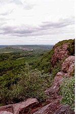
feet (91 m) below. The mountain is traversed by the 50-mile (80 km) Mattabesett Trail. Roughly 0.75 miles (1.2 km) in diameter, Chauncey Peak is located...
8 KB (886 words) - 15:16, 3 July 2023

Elizabeth J. (2004-07-17). "Metacomet-Mattabesett Trail Natural Resource Assessment" (PDF). Metacomet-Mattabesett Trail. Archived from the original on 2007-08-07...
8 KB (852 words) - 13:08, 12 May 2024
types of trails: the national scenic trails, national historic trails, national recreation trails, and connecting or side trails. The national trails provide...
60 KB (2,726 words) - 15:08, 2 January 2024

visible for miles. The mountain is traversed by the 50-mile (80 km) Mattabesett Trail. Lamentation Mountain takes its name from an incident in 1653 when...
9 KB (919 words) - 15:16, 3 July 2023
(3 km) long ledge. The mountain is traversed by the 50-mile (80 km) Mattabesett Trail. Located within the towns of Middletown, Meriden, and Middlefield...
10 KB (1,002 words) - 15:16, 3 July 2023

Metacomet Trail and its logical extension, the Mattabesett Trail), and 50 miles (80 km) farther north into central New Hampshire. Other long hiking trails that...
31 KB (3,510 words) - 19:44, 24 April 2024
the Metacomet-Monadnock Trail in Massachusetts and the Mattabesett Trail and Metacomet Trail trails in Connecticut. The East Granby Land Trust has played...
8 KB (801 words) - 09:20, 3 November 2023

Hiking Trail created, followed by the Metacomet Trail and Mattabesett Trail in 1931–1932. During the Depression the size of the Blue-Blazed Hiking Trail system...
15 KB (1,994 words) - 17:22, 30 December 2023

Sleeping Giant (Connecticut) (redirect from Sleeping Giant State Park Trails)
Retrieved August 15, 2016. Farnsworth, Elizabeth J. (2004). "Metacomet-Mattabesett Trail Natural Resource Assessment" (PDF). Archived from the original (PDF)...
22 KB (2,246 words) - 04:24, 8 November 2023

"Blue" "non-dot") trail is primarily a north / south linear trail with a northern trail head which terminates at the Mattabesett Trail near its southernmost...
10 KB (975 words) - 14:11, 6 March 2023

Metacomet Ridge Metacomet Trail Mattabesett Trail Adjacent summits: Farnsworth, Elizabeth J. (2004) "Metacomet-Mattabesett Trail Natural Resource Assessment...
14 KB (1,430 words) - 14:19, 4 January 2024
stretching from the Hudson to the Connecticut" rivers. Mattabesset River Mattabesett Trail De Forest ix Salwen 173 De Forest 54 Barber 507 De Forest 241–242...
6 KB (669 words) - 06:48, 4 June 2022

Massachusetts and the Mattabesett Trail and Metacomet Trail trails in Connecticut. Metacomet Ridge Metacomet-Monadnock Trail Robert Frost Trail (Massachusetts)...
13 KB (1,496 words) - 02:28, 11 January 2024

plant communities. The mountain is traversed by the 51-mile (82 km) Mattabesett Trail. Trimountain is located in Durham and Wallingford, Connecticut. It...
7 KB (705 words) - 15:13, 3 July 2023

Pond Trail opened in October 2013. A 0.5-mile (0.8 km) section of rail trail along Highland Pond in southwestern Middletown is part of the Mattabesett Trail...
24 KB (2,567 words) - 23:15, 24 May 2023
valley to the west. The mountain is traversed by the 50-mile (80 km) Mattabesett Trail. Located within the towns of Durham and Wallingford, Connecticut,...
7 KB (712 words) - 15:13, 3 July 2023

plant communities. The mountain is traversed by the 51-mile (82 km) Mattabesett Trail, and is home to the Powder Ridge Ski Area. According to the Connecticut...
12 KB (1,292 words) - 05:23, 7 October 2023

million restoration. It now includes a visitors' center and museum, hiking trails, and a picnic area. William Gillette's "castle", called Seventh Sister and...
13 KB (1,311 words) - 22:54, 3 April 2024

valley to the west. The mountain is traversed by the 50-mile (80 km) Mattabesett Trail. Located within the town of Durham, Pistapaug Mountain is 2 miles...
7 KB (693 words) - 15:14, 3 July 2023

Westwoods Trails is an extensive hiking trail system in Guilford, Connecticut. The trail system has approximately 39 miles (63 km) of trails with features...
5 KB (663 words) - 17:00, 28 April 2024

Farmington Canal Heritage Trail is an 82-mile (132 km) multi-use rail trail located in Connecticut and Massachusetts. The trail was built on former New...
9 KB (1,001 words) - 03:32, 30 April 2024

Regicides Trail is a Blue-Blazed hiking trail, about 7 miles (11 km) long, roughly following the edge of a diabase, or traprock, cliff northwest of New...
8 KB (1,016 words) - 11:20, 31 December 2023

Retrieved January 1, 2008. Farnsworth, Elizabeth J. (2004)."Metacomet-Mattabesett Trail Natural Resource Assessment." Archived 2007-08-07 at the Wayback Machine...
17 KB (1,914 words) - 03:32, 9 February 2024

(80 km) Mattabesett Trail traverses Bluff Head; a shorter network of trails criss-cross the Sugarloaves. Guilford also contains the Westwoods Trail System...
25 KB (2,044 words) - 21:09, 28 April 2024

Mountain is traversed by the 50 mi (80 km) Mattabesett Trail and a significant network of shorter trails. The name "Totoket Mountain" applies to both...
11 KB (1,256 words) - 07:02, 15 March 2024

Metacomet-Monadnock Trail Guide. 9th Edition. The Appalachian Mountain Club. Amherst, Massachusetts, 1999. Farnsworth, Elizabeth J. "Metacomet-Mattabesett Trail Natural...
13 KB (1,318 words) - 05:49, 28 November 2023