 | Maysville is an unincorporated community and census-designated place (CDP) in Benton County, Arkansas, United States. It is the westernmost settlement... 7 KB (308 words) - 16:29, 14 May 2024 |
Maysville is the name of several places in the United States of America: Maysville, Alabama Maysville, Arkansas Maysville, Colorado Maysville, Georgia... 870 bytes (119 words) - 13:25, 16 June 2018 |
 | Senator from Missouri influential in Arkansas's statehood. Early white settlements were established at Maysville and Cross Hollow, but a new centrally... 33 KB (2,050 words) - 13:43, 22 April 2024 |
Battle of Old Fort Wayne (redirect from Battle of Maysville) The Battle of Old Fort Wayne, also known as Maysville, Beattie's Prairie, or Beaty's Prairie, was an American Civil War battle on October 22, 1862, in... 11 KB (1,100 words) - 13:47, 26 February 2023 |
 | The following is a list of state highways in the U.S. state of Arkansas. The state does not use a numbering convention. Generally, the two-digit odd numbered... 244 KB (1,754 words) - 02:30, 7 April 2024 |
 | Local access and transport area (section Arkansas) Missouri Includes area of Oklahoma near Maysville, Arkansas Includes area of Oklahoma near Uniontown, Arkansas 528 Little Rock Includes Watson, Oklahoma... 27 KB (2,562 words) - 15:45, 7 June 2023 |
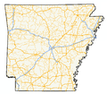
 | state highways in Benton County, Arkansas. A western route of 26.32 miles (42.36 km) runs east from Highway 43 at Maysville to U.S. Route 71B (US 71B) in... 9 KB (561 words) - 16:29, 16 February 2024 |
near the community of Maysville, Arkansas Nothing remains of the fort at either location. The area is located on the Oklahoma/Arkansas border just south of... 4 KB (462 words) - 04:52, 7 November 2023 |
 | through Cherokee City before meeting AR 102 and later AR 72 in Maysville. After Maysville, AR 43 runs along the Oklahoma state line concurrent with Oklahoma... 13 KB (967 words) - 02:58, 14 March 2024 |
Sellers Farm (category Houses on the National Register of Historic Places in Arkansas) The Sellers Farm was a historic farmstead in Maysville, Arkansas, USA. The main house was a two-story I-house with a rear wing giving it an overall T... 3 KB (209 words) - 09:25, 26 April 2024 |
 | onto AR 100. The application was approved, which caused AR 102 between Maysville and Gravette to be redesignated as AR 72, truncating the route at Decatur... 15 KB (1,336 words) - 16:29, 16 February 2024 |
remains of an unknown female were discovered along Arkansas Highway 102 near Maysville, Arkansas. The cause of death was determined to be a gunshot wound... 286 KB (35,371 words) - 14:57, 15 May 2024 |
 | Barry Odom (category People from Maysville, Oklahoma) school football as a linebacker and running back at Maysville Junior-Senior High School in Maysville, Oklahoma, before transferring to Ada High School in... 21 KB (2,218 words) - 20:41, 14 May 2024 |
 | Arkansas Highway 59 is a north–south state highway in Northwest Arkansas. The route runs 93.24 miles (150.06 km) from Arkansas Highway 22 in Barling north... 13 KB (632 words) - 16:28, 16 February 2024 |
Army of the Frontier (category Arkansas in the American Civil War) River with 4,600 men. Blunt's men were 15 miles (24 km) south of Maysville, Arkansas, at Lindsey's Prairie. As of November, the Army of the Frontier was... 17 KB (2,372 words) - 06:39, 12 April 2024 |
 | Coats School (category School buildings on the National Register of Historic Places in Arkansas) rural Benton County, Arkansas. It is located near the end of Coats Road (County Road 391), near Spavinaw Creek, south of Maysville. It is built of ashlar... 2 KB (128 words) - 22:52, 2 August 2022 |
 | of U.S. Route 62 currently exist. Seven of them lie within the state of Arkansas. Three existed in the past but have since been decommissioned. Business... 36 KB (2,899 words) - 01:20, 28 February 2024 |
5. Scout in Northern Arkansas May 17–22 (Co. "M"). Scout from Cassville to Cross Hollows June 9–14 and June 20–24. Near Maysville July 20. Operations in... 5 KB (634 words) - 09:43, 8 October 2022 |
 | Arkansas Highway 12 is an east–west state highway in Northwest Arkansas. The route runs 56.60 miles (91.09 km) from Oklahoma State Highway 116 near Cherokee... 11 KB (610 words) - 04:56, 8 September 2023 |
| U.S. Route 62 (section Arkansas) After passing through Georgetown and Cynthiana it leaves Kentucky in Maysville over the Simon Kenton Memorial Bridge. US 62 is the only US Highway to... 36 KB (3,677 words) - 00:59, 13 May 2024 |
 | the 1926 Arkansas state highway numbering. The initial route started at State Road 80 near Summers and ran north to State Road 102 at Maysville. In 1928... 6 KB (626 words) - 22:58, 8 March 2024 |
House (Beebe, Arkansas), listed on the NRHP in Arkansas Sellers House (Conway, Arkansas), listed on the NRHP in Arkansas Sellers Farm, Maysville, AR, listed... 666 bytes (121 words) - 09:54, 20 March 2013 |
 | of the National Register of Historic Places listings in Benton County, Arkansas. This is intended to be a complete list of the properties and districts... 55 KB (318 words) - 05:31, 13 March 2024 |
Beaty Creek (category Rivers of Benton County, Arkansas) miles west of Gravette and it flows west crossing under Arkansas Route 43 just north of Maysville and crosses the state line into Oklahoma. In Oklahoma... 2 KB (205 words) - 13:29, 14 April 2021 |
 | (Delaware and Maryland), Newport and Cincinnati Bridge (Kentucky and Ohio), Maysville-Aberdeen Bridge (Kentucky and Ohio), Nez Perce Snake River Archeological... 22 KB (1,178 words) - 01:40, 10 August 2023 |
 | Marion 19,581 347 Marshall 31,659 305 Martin 11,287 231 Mason 17,120 241 Maysville, KY Micropolitan Statistical Area McCracken 67,875 251 Paducah, KY-IL... 327 KB (1,443 words) - 15:39, 25 April 2024 |
List of bridges in the United States (redirect from List of bridges in Arkansas) 142+323+142 U.S. Route 62 U.S. Route 68 Ohio State Route 41 Ohio River 1932 Maysville–Aberdeen 38°38′59.5″N 83°45′34.5″W / 38.649861°N 83.759583°W / 38.649861;... 111 KB (5,118 words) - 13:07, 28 April 2024 |
 | S. state of Arkansas renumbered its highways into a more traditional format. The system to be replaced was established in 1924 as Arkansas' first comprehensive... 16 KB (174 words) - 21:34, 20 July 2023 |
Kentucky to Coal Grove, Ohio Simon Kenton Memorial Bridge, connects Maysville, Kentucky to Aberdeen, Ohio The Singing Bridge crosses the Kentucky River... 101 KB (9,295 words) - 01:17, 16 May 2024 |
Gravette School District (category School districts in Arkansas) accredited by the Arkansas Department of Education (ADE) and AdvancED. The district includes the majority of Gravette, as well as all of Maysville and Sulphur... 3 KB (173 words) - 21:34, 25 July 2023 |