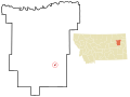
 | McCone County is a county located in the U.S. state of Montana. As of the 2020 census, the population was 1,729. Its county seat is Circle. The county... 11 KB (744 words) - 01:25, 16 January 2024 |
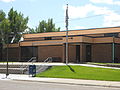
 | Circle is a town in and the county seat of McCone County, Montana, United States. The population was 591 at the 2020 census. The community was so named... 17 KB (1,222 words) - 21:10, 6 March 2024 |
 | both Flathead and Glacier counties, the Lewis and Clark Bridge spans the Missouri River between McCone and Roosevelt counties, the Butte, Anaconda and... 59 KB (640 words) - 13:19, 12 April 2024 |
(secondary coordinates) There are at least 26 named mountains in McCone County, Montana. Andrews Hill, 47°48′06″N 106°11′12″W / 47.80167°N 106.18667°W... 5 KB (1,164 words) - 17:27, 20 March 2022 |
coordinates) There are at least 28 named lakes and reservoirs in McCone County, Montana. Fort Peck Lake, 48°00′10″N 106°24′58″W / 48.00278°N 106.41611°W... 6 KB (1,279 words) - 23:09, 22 March 2024 |
Gina McCone, fictional character of Stephen King's The Stand Sharon McCone, fictional detective created by Marcia Muller McCone County, Montana, named... 984 bytes (144 words) - 17:02, 19 November 2021 |
Park to the north of the Forbidden City in Beijing Coal Hill in McCone County, Montana Coal Hill Coal Railroad, a railroad in Mt Washington, Pittsburgh... 692 bytes (91 words) - 06:08, 6 January 2016 |
(CDP) in McCone County, Montana, United States. It is on the northern edge of the county, just south of the Missouri River, which forms the county line.... 4 KB (139 words) - 21:08, 13 July 2023 |
and census-designated place (CDP) in northern McCone County, Montana, United States, located on Montana Highway 13 along the Big Sky Back Country Byway... 6 KB (332 words) - 05:57, 14 July 2023 |
Disappearance of Patricia Meehan (category McCone County, Montana) American woman who disappeared following a car crash on Montana Highway 200 near Circle, Montana. Investigators initially suspected Meehan had fled the... 16 KB (1,726 words) - 23:48, 20 March 2024 |
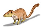 | Paleocene section of the Hell Creek Formation. Both locations are in McCone County, Montana. They have also been found in the Ravenscrag Formation and widely... 15 KB (1,566 words) - 02:36, 19 February 2024 |
unincorporated community and census-designated place (CDP) in southern McCone County, Montana, United States, located near the Redwater River. At the 2000 census... 9 KB (317 words) - 16:55, 15 December 2023 |
 | Redwater River (category Bodies of water of McCone County, Montana) plains past Brockway and Circle and joins the Missouri in northeastern McCone County, approximately 4 mi (6 km) south of Poplar. The Redwater River has also... 3 KB (130 words) - 00:22, 9 December 2023 |
 | Fort Peck Lake (redirect from Fort Peck Lake, Montana) major reservoir in Montana, formed by the Fort Peck Dam on the Missouri River. The lake lies in the eastern prairie region of Montana approximately 140... 13 KB (769 words) - 01:18, 16 October 2023 |
Big Heaven (category Mountains of McCone County, Montana) Big Heaven is a summit in McCone County, Montana, in the United States. With an elevation of 2,579 feet (786 m), Big Heaven is the 3215th highest summit... 643 bytes (72 words) - 14:23, 29 June 2023 |
 | Fort Peck Dam (category National Register of Historic Places in McCone County, Montana) were Wheeler and McCone City as well as more than a dozen others. Many of the homes were later moved to farms and towns around Montana. Fort Peck Dam is... 22 KB (2,461 words) - 23:13, 31 March 2024 |
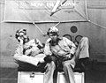 | Swede Vejtasa (category People from McCone County, Montana) isolated homestead in Montana on July 27, 1914. He attended Montana State College, before transferring to the University of Montana. He joined the Navy... 20 KB (1,668 words) - 09:42, 19 February 2024 |
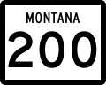 | Montana Highway 200 (MT 200) in the U.S. state of Montana is a route running east–west covering the entire state of Montana. From the starting point at... 27 KB (1,320 words) - 07:15, 9 February 2024 |
David Rorvik (category People from McCone County, Montana) considered to be a hoax. Rorvik was born in Circle, Montana. He graduated with a B.A. from the University of Montana in 1966 and a M.S. summa cum laude from the... 8 KB (961 words) - 03:19, 11 April 2022 |
 | County, North Dakota – southeast Richland County – south McCone County – southwest Valley County - west Fort Union Trading Post National Historic Site (part)... 17 KB (848 words) - 01:26, 16 January 2024 |
 | and Garfield County and part of McCone County in 1919. Interstate 94 U.S. Highway 10 (Former) Montana Highway 16 Montana Highway 200 Montana Highway 200... 15 KB (1,413 words) - 11:06, 17 April 2024 |
 | Missouri River (category Bodies of water of McCone County, Montana) Mountains of the Bitterroot Range of the Rocky Mountains of southwestern Montana, then flows east and south for 2,341 miles (3,767 km) before entering the... 189 KB (18,043 words) - 23:28, 10 April 2024 |
Wolf Creek (section Montana) River Wolf Creek (McCone County, Montana), a tributary of the Redwater River in McCone County Wolf Creek (Roosevelt County, Montana), a tributary of the... 3 KB (461 words) - 19:25, 14 October 2022 |
Milk River Hills (category Landforms of McCone County, Montana) (806 m), is a set of hills east of Fort Peck, Montana in McCone County, Montana. List of mountain ranges in Montana "Milk River Hills". Geographic Names Information... 1 KB (49 words) - 20:49, 20 October 2020 |
 | Turtle Mountain Indian Reservation (category Geography of McCone County, Montana) [citation needed] These lands are spread across 22 counties in three states: North Dakota, Montana, and South Dakota. Including these lands, the reservation's... 28 KB (3,130 words) - 14:13, 9 August 2023 |
 | Montana (M-Z) List of mountains in Madison County, Montana List of mountains in McCone County, Montana List of mountains in Meagher County, Montana List... 4 KB (586 words) - 18:51, 4 November 2023 |
 | presidential election[update], this is the last election in which McCone County and Wibaux County voted for a Democratic Presidential candidate. Carter became... 31 KB (255 words) - 13:28, 13 April 2024 |
 | station) Phillips County - west Garfield County - south McCone County - south Roosevelt County - east Daniels County - east Rural Municipality (RM) of Mankota... 15 KB (912 words) - 11:06, 17 April 2024 |
 | County, Montana Liberty County, Montana Lincoln County, Montana Madison County, Montana McCone County, Montana Meagher County, Montana Mineral County... 118 KB (11,971 words) - 02:15, 25 September 2023 |
| Nevertheless, the hotel served as temporary lodging for new settlers in McCone County and functioned as a community meeting place, including a local bar that... 3 KB (249 words) - 20:35, 26 January 2024 |