 | McDowell County is a county located in the U.S. state of North Carolina. As of the 2020 census, the population was 44,578. Its county seat is Marion.... 29 KB (2,563 words) - 14:26, 27 April 2024 |
 | Marion is a city in and the county seat of McDowell County, North Carolina, United States. Founded in 1844, the city was named in honor of Brigadier General... 25 KB (2,583 words) - 13:38, 28 March 2024 |
McDowell County is the name of two counties in the United States: McDowell County, North Carolina McDowell County, West Virginia This disambiguation page... 169 bytes (54 words) - 10:10, 29 December 2019 |
Providence is an unincorporated community in McDowell County, North Carolina, United States. Providence is 4 miles (6.4 km) southwest of Marion. U.S.... 2 KB (38 words) - 04:12, 28 July 2023 |
 | Old Fort is a town in McDowell County, North Carolina, United States. The population was 811 people in the 2020 U.S. census. Before the arrival of European... 20 KB (1,555 words) - 17:17, 7 May 2024 |
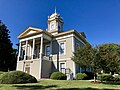
 | McDowell County Courthouse is a historic courthouse building located at Marion, McDowell County, North Carolina. It was designed by architect Erle G.... 2 KB (135 words) - 00:43, 8 August 2023 |
MacDowell Lake, a lake in Ontario McDowell, Kentucky, an unincorporated community McDowell, Missouri, an unincorporated community McDowell County, North... 1 KB (143 words) - 00:17, 9 May 2021 |
 | Carolina Department of Transportation. McDowell County (Map). North Carolina Department of Transportation. Retrieved April 30, 2014. North Carolina Department... 124 KB (10,271 words) - 01:12, 7 May 2024 |
 | unincorporated community in McDowell and Mitchell counties of North Carolina, United States. It is located along North Carolina Highway 226A (NC 226A) off... 7 KB (551 words) - 02:04, 27 July 2023 |
"Pleasant Gardens" McDowell (February 25, 1758 – May 18, 1795) was an American lawyer, soldier, and statesman from Morganton, North Carolina. His estate was... 4 KB (285 words) - 15:47, 20 May 2023 |
 | "Quaker Meadows" McDowell Jr. (February 15, 1756 – July 11, 1801) was an American planter, soldier, and statesman from North Carolina. He was known as... 7 KB (520 words) - 00:22, 22 January 2024 |
 | the central and eastern portion of the state. US 64 enters North Carolina in Cherokee County, west of Murphy. The highway serves the cities of Hendersonville... 64 KB (3,935 words) - 22:32, 25 January 2024 |
 | located in Marion, North Carolina. It was the home of Col. John Carson, and served as the McDowell County courthouse when the county was first organized... 7 KB (737 words) - 13:32, 12 December 2023 |
 | community at the junction of Avery, Burke, and McDowell counties in the U.S. state of North Carolina. The community is named after Linville Falls, a... 4 KB (127 words) - 20:57, 23 December 2020 |
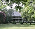
 | The Joseph McDowell House is a historic house and museum located in Marion, McDowell County, North Carolina. It was the home of Colonel Joseph "Pleasant... 5 KB (553 words) - 04:11, 15 July 2023 |
 | 3, 2016. North Carolina Department of Transportation (September 2015). McDowell County, North Carolina (PDF) (Map). Raleigh: North Carolina Department... 163 KB (12,521 words) - 15:53, 29 April 2024 |
 | Burke County is a county located in the U.S. state of North Carolina. As of the 2020 census, its population was 87,570. Its county seat is Morganton. Burke... 23 KB (1,948 words) - 14:18, 27 April 2024 |
 | North Carolina (PDF) (Map). North Carolina Department of Transportation. September 2015. Retrieved March 22, 2016. McDowell County, North Carolina (PDF)... 19 KB (1,154 words) - 22:22, 23 April 2023 |
 | Buncombe County (/ˈbʌŋkəm/ BUNK-um) is a county located in the U.S. state of North Carolina. It is classified within Western North Carolina. The 2020 census... 33 KB (2,799 words) - 22:32, 5 May 2024 |
census-designated place (CDP) in the Nebo Township of eastern McDowell County, North Carolina, United States. It was first listed as a CDP in the 2020 census... 7 KB (388 words) - 14:55, 3 August 2023 |
parts of: Burke County, North Carolina McDowell County, North Carolina Greenville County, South Carolina Newberry County, South Carolina The Catawba Indian... 8 KB (950 words) - 06:03, 27 January 2023 |
 | Lake Tahoma (category Bodies of water of McDowell County, North Carolina) Tahoma is a private lake in the mountains of Western North Carolina, United States, in McDowell County. It is fed by the waters of Buck Creek, a tributary... 2 KB (74 words) - 02:39, 25 September 2020 |
 | Mecklenburg County (/ˈmɛklənˌbɜːrɡ/) is a county located in the southwestern region of the U.S. state of North Carolina, in the United States. As of the... 58 KB (4,593 words) - 22:30, 4 May 2024 |
 | Rutherford County is a county in the southwestern area of the U.S. state of North Carolina. As of the 2020 census, the population was 64,444. Its county seat... 30 KB (2,372 words) - 14:30, 27 April 2024 |
senator, and County Justice of Peace in Burke County, North Carolina. Charles McDowell was born on October 18, 1743, in Winchester, Frederick County, Virginia... 4 KB (312 words) - 04:45, 2 April 2023 |
 | McDowell County, North Carolina (PDF) (Map). North Carolina Department of Transportation. September 2015. Retrieved March 21, 2016. Mitchell County,... 10 KB (861 words) - 17:42, 16 February 2024 |
 | Catawba Falls (category Protected areas of McDowell County, North Carolina) waterfalls on the headwaters of the Catawba River, in McDowell County, near Old Fort, North Carolina. The Catawba River flows over 2 major waterfalls in... 4 KB (324 words) - 02:28, 30 August 2023 |
 | Lake James State Park (category Protected areas of McDowell County, North Carolina) Park is a North Carolina state park in Burke and McDowell counties, North Carolina in the United States. Located near Nebo, North Carolina, it covers... 5 KB (283 words) - 16:19, 17 August 2023 |
 | Blue Ridge Parkway (category Protected areas of McDowell County, North Carolina) park in the U.S., runs for 469 miles (755 km) through 29 counties in Virginia and North Carolina, linking Shenandoah National Park to Great Smoky Mountains... 65 KB (4,790 words) - 17:34, 5 May 2024 |
 | Lake James (redirect from Lake James, North Carolina) reservoir in the mountains of Western North Carolina which straddles the border between Burke and McDowell Counties. It is named for tobacco tycoon and... 12 KB (1,105 words) - 18:18, 21 February 2024 |