 | Mecúfi District is a district of Cabo Delgado Province in northern Mozambique. It is bordered in the north by the district capital of Pemba and the Metuge... 5 KB (402 words) - 15:08, 12 May 2024 |
 | Macomia Mucojo Cabo Delgado Macomia Quiterajo Cabo Delgado Mecúfi Mecúfi Cabo Delgado Mecúfi Murrebue Cabo Delgado Meluco Meluco Cabo Delgado Meluco Muaguide... 30 KB (39 words) - 19:46, 8 February 2024 |
 | Chicualacuala District (Portuguese: Distrito de Chicualacuala) is a district of Gaza Province in south-western Mozambique. It has a population of 41,638... 8 KB (528 words) - 16:07, 24 March 2021 |
 | kilometres (131 mi) long. All roads are in a very bad state. "Perfil do Distrito de Magoé" (PDF) (in Portuguese). Ministry of State Administration. 2005... 6 KB (314 words) - 05:01, 25 April 2021 |
 | kilometres (21 mi) of national road between Macia and Bilene. "Perfil do Distrito de Bilene Macia" (PDF) (in Portuguese). Ministry of State Administration... 6 KB (400 words) - 17:43, 28 March 2024 |
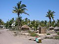
(postos), Nacala-a-Velha (pop. 80,155), and Covo (pop. 26,387). "Perfil do Distrito de Nacala Província de Nampula". Ministério da Administração Estatal, República... 1 KB (158 words) - 13:53, 5 February 2023 |
 | 120 kilometres (75 mi) stretch of the national road EN103. "Perfil do Distrito de Changara" (PDF) (in Portuguese). Ministry of State Administration. 2005... 6 KB (329 words) - 03:13, 29 April 2024 |
 | (91 mi) of the national road EN102 connecting Chimoio and Tete. "Perfil do Distrito de Báruè" (PDF) (in Portuguese). Ministry of State Administration. 2005... 6 KB (354 words) - 07:47, 15 July 2023 |
 | railway line, between Moamba and Xinavane, is not in operation. "Perfil do Distrito de Moamba" (PDF) (in Portuguese). Ministry of State Administration. 2005... 6 KB (368 words) - 22:54, 9 January 2021 |
 | eastern part of the district, passing the town of Morrumbene. "Perfil do Distrito de Massinga" (PDF) (in Portuguese). Ministry of State Administration. 2005... 6 KB (359 words) - 21:28, 9 January 2021 |
 | of the roads in Homoine District is 300 kilometres (190 mi). "Perfil do Distrito de Homoine" (PDF) (in Portuguese). Ministry of State Administration. 2005... 6 KB (387 words) - 21:34, 9 January 2021 |
 | consists of two secondary roads, ER428 and ER429, in a bad state. "Perfil do Distrito do Machanga" (PDF) (in Portuguese). Ministry of State Administration. 2005... 6 KB (322 words) - 10:33, 28 April 2021 |
 | Zimbabwe. The railway from Beira to Zimbabwe crosses the district. "Perfil do Distrito do Nhamatanda" (PDF) (in Portuguese). Ministry of State Administration... 6 KB (369 words) - 18:56, 25 January 2021 |
 | the district from south to north. There is also an airfield. "Perfil do Distrito do Chibabava" (PDF) (in Portuguese). Ministry of State Administration.... 6 KB (337 words) - 08:52, 18 December 2022 |
 | kilometres (358 mi) long. Most of the roads are in a bad state. "Perfil do Distrito de Guro" (PDF) (in Portuguese). Ministry of State Administration. 2005... 6 KB (363 words) - 11:50, 21 December 2023 |
 | the secondary roads are paved, and most are in a bad state. "Perfil do Distrito de Massingir" (PDF) (in Portuguese). Ministry of State Administration.... 7 KB (419 words) - 18:39, 14 April 2021 |
 | connecting Beira with Zimbabwe via Machipanda crosses the district. "Perfil do Distrito de Manica" (PDF) (in Portuguese). Ministry of State Administration. 2005... 6 KB (347 words) - 11:54, 27 May 2021 |
 | stretches of national roads EN2, connecting Maputo and Eswatini. "Perfil do Distrito de Namaacha" (PDF) (in Portuguese). Ministry of State Administration. 2005... 6 KB (329 words) - 14:12, 16 March 2021 |
 | There is semi-public transportation between Chemba and Beira. "Perfil do Distrito do Chemba" (PDF) (in Portuguese). Ministry of State Administration. 2005... 6 KB (336 words) - 13:12, 15 July 2022 |
 | running from Maputo along the coast to the north of Mozambique. "Perfil do Distrito da Manhiça" (PDF) (in Portuguese). Ministry of State Administration. 2005... 6 KB (403 words) - 17:25, 18 October 2022 |
 | potable water from boreholes (hand pumps / solar pumps): ??. "Perfil do Distrito de Xai-Xai" (PDF) (in Portuguese). Ministry of State Administration. 2005... 6 KB (436 words) - 09:46, 9 March 2024 |
 | connecting Furancungo and Mualadzi with the Matema Crossing. "Perfil do Distrito de Macanga" (PDF) (in Portuguese). Ministry of State Administration. 2005... 6 KB (349 words) - 17:39, 28 March 2024 |
 | Limpopo Railroad (Southern System) runs through the district. "Perfil do Distrito de Mabalane" (PDF) (in Portuguese). Ministry of State Administration. 2005... 6 KB (439 words) - 17:26, 28 March 2024 |
 | Theology course at their Instituto Cristão de Moçambique-College. "Perfil do Distrito de Angónia" (PDF) (in Portuguese). Ministry of State Administration. 2005... 7 KB (536 words) - 12:50, 27 March 2021 |
 | (310 mi) of secondary roads become impassable in the rainy season. "Perfil do Distrito de Mabote" (PDF) (in Portuguese). Ministry of State Administration. 2005... 6 KB (385 words) - 23:26, 9 January 2021 |
 | Bazaruto Island Airport located on the Bazaruto Archipelago. "Perfil do Distrito de Vilankulo" (PDF) (in Portuguese). Ministry of State Administration.... 6 KB (363 words) - 16:50, 23 May 2021 |
 | It is used by lodges which charter flights from Vilankulo. "Perfil do Distrito de Inhassoro" (PDF) (in Portuguese). Ministry of State Administration.... 7 KB (431 words) - 14:40, 17 January 2021 |
 | the roads in Funhalouro District is 878 kilometres (546 mi). "Perfil do Distrito de Funhalouro" (PDF) (in Portuguese). Ministry of State Administration... 6 KB (388 words) - 21:31, 14 May 2024 |
 | length of the roads in the district is 233 kilometres (145 mi). "Perfil do Distrito de Zavala" (PDF) (in Portuguese). Ministry of State Administration. 2005... 6 KB (363 words) - 17:35, 28 March 2024 |
 | a road network in the district 156 kilometres (97 mi) long. "Perfil do Distrito do Dondo" (PDF) (in Portuguese). Ministry of State Administration. 2005... 6 KB (423 words) - 19:59, 1 May 2022 |