Milecastle 34 (Grindon) was a milecastle of the Roman Hadrian's Wall. There are no visible remains, but the site is within a small, tree-filled, walled...
8 KB (883 words) - 23:12, 11 April 2022

A milecastle was a small fort (fortlet), a rectangular fortification built during the period of the Roman Empire. They were placed at intervals of approximately...
26 KB (2,011 words) - 11:14, 26 September 2023
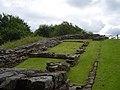
Milecastle 48 (Poltross Burn), is a milecastle on Hadrian's Wall (grid reference NY6340666195). Its remains lie near the village of Gilsland in Cumbria...
7 KB (770 words) - 17:26, 17 March 2022

Soldiers were garrisoned along the line of the wall in large forts, smaller milecastles, and intervening turrets. In addition to the wall's defensive military...
69 KB (7,739 words) - 16:46, 17 May 2024

Milecastle 2 (Walker) was a milecastle of the Roman Hadrian's Wall. No remains are currently visible, having been built over, but its probable location...
6 KB (558 words) - 23:11, 11 April 2022

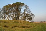
Milecastle 35 (Sewingshields) is one of the milecastles on Hadrian's Wall (grid reference NY80497018). The remains still exist as exposed masonry. The...
5 KB (484 words) - 23:12, 11 April 2022
Milecastle 13 (Rudchester Burn) was a milecastle of the Roman Hadrian's Wall. Its remains exist as a low platform south of the B6318 Military Road. Milecastle...
6 KB (654 words) - 23:11, 11 April 2022

Milecastle 45 (Walltown) was a milecastle on Hadrian's Wall (grid reference NY67716657). Milecastle 45 is located on the top of Walltown Crags. The walls...
4 KB (391 words) - 00:49, 14 March 2024

north-east, joining the Irthing at Gilsland. The well-preserved Roman Milecastle 48, a feature of Hadrian's Wall once known locally as The King's Stables...
921 bytes (111 words) - 03:34, 20 April 2022

Limestone Corner (section Milecastle 30)
Milecastle 30. Also present is a trig point. The B6318 Military Road also runs through Limestone Corner, as does the Military Way, serving Milecastle...
10 KB (1,161 words) - 07:04, 17 July 2022
13 December 2017 (2017-12-13) N/A Roman cavalry special Sites and archaeology featured: Milecastle 37 Barracks of Chesters Bridge Fort Ribchester Roman Cavalry Fort Vindolanda...
56 KB (1,005 words) - 19:43, 30 April 2024

military road led from it and followed the Wall, linking its forts and milecastles. The bridge and its fort were built at the north end of Cade's Road,...
13 KB (1,508 words) - 00:02, 20 March 2024
Simon (1991). Robin Hood: Prince of Thieves. Bdd Promotional Book Co. pp. 22–34. ISBN 9780792456339. Else, David & Sandra Bardwell, Belinda Dixon, Peter Dragicevich...
44 KB (3,648 words) - 15:07, 13 May 2024

on the Epigraphic Database Roma) Morwood 2013, pp. 5 & 43. Opper 2008, p. 34. On the numerous senatorial families from Spain residing at Rome and its vicinity...
138 KB (17,419 words) - 19:44, 4 May 2024
for its sulphurous spa waters, is close by to the north. Poltross Burn Milecastle, a strongpoint of Hadrian's Wall once known locally as The King's Stables...
10 KB (1,186 words) - 09:48, 29 January 2024

on the move, to elaborate permanent stone constructions, notably the milecastles of Hadrian's Wall. Roman forts were generally rectangular with rounded...
112 KB (13,798 words) - 07:02, 18 May 2024

expansion, particularly the large network of Roman roads and the many milecastles, made the measuring rod an indispensable part of both the military and...
21 KB (2,256 words) - 22:25, 19 November 2023
it, may have taken six years to construct. Small guard posts called milecastles were built at mile intervals with an additional two fortified observation...
67 KB (8,771 words) - 03:49, 1 May 2024

of the nearby coastline. It was built over the site of the eightieth milecastle. The fort was originally built with a turf and clay rampart, similar to...
8 KB (663 words) - 15:33, 1 July 2023
and vallum between the River Irthing and the field boundaries east of milecastle 50 Listed on the National Heritage List for England". Historic England...
12 KB (367 words) - 22:13, 1 December 2023

structures of the Wall, and by about 1930 it had become standard, using the milecastle located to the east. Examples are T33a or Turret 26B (Brunton). His interest...
9 KB (1,103 words) - 01:34, 7 February 2024

response was to provide a frontier zone in the western sector of forts and milecastles, built of turf and timber (the "Turf Wall"), the standard construction...
204 KB (27,907 words) - 00:51, 1 May 2024

Milefortlet 5 (category Milecastles of Hadrian's Wall)
Handbook to the Roman Wall, with the Cumbrian coast and outpost forts, page 34. H. Hill Historic England, "Monument No. 1009473", Research records (formerly...
4 KB (414 words) - 11:09, 13 October 2023

Milefortlet 9 (category Milecastles of Hadrian's Wall)
Handbook to the Roman Wall, with the Cumbrian coast and outpost forts, page 34. H. Hill Historic England, "Tower 9A (9635)", Research records (formerly PastScape)...
4 KB (452 words) - 23:42, 20 January 2024
Historic England, "Railway Bridge across the Poltross Burn, north of Milecastle 48, Hadrian's wall, Upper Denton (1045226)", National Heritage List for...
12 KB (496 words) - 04:49, 20 April 2022
K. S., Richmond, I. A. and Simpson, F. Gerald. (1952) "Turrets and milecastles between Burgh-by-Sands and Bowness-on-Solway." Transactions of the Cumberland...
11 KB (1,253 words) - 21:51, 17 February 2024

54°59′22″N 2°34′00″W / 54.989472°N 2.566743°W / 54.989472; -2.566743 (Hadrian's Wall Milecastle and Turrets Hadrians Wall, Milecastle and Turrets)...
77 KB (139 words) - 12:25, 18 January 2024
elegant bridge with four arches supported on three substantial river piers, 34 feet (10.4 m) apart. Its overall length was 189 feet (57.6 m) and was intended...
7 KB (835 words) - 16:34, 6 February 2023