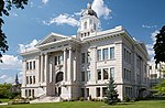
 | Missoula County /mɪˈzuːlə/ is located in the State of Montana. As of the 2020 census, the population was 117,922, making it Montana's third most populous... 29 KB (2,052 words) - 23:59, 25 April 2024 |
 | population of the Missoula Metropolitan Area at 122,458. Missoula is the 2nd largest city and metropolitan area in Montana. Missoula is home to the University... 163 KB (14,752 words) - 05:07, 6 May 2024 |
 | Missoula Montana Airport (IATA: MSO, ICAO: KMSO, FAA LID: MSO) is located in Missoula, in Missoula County, Montana. It is owned by the Missoula County... 17 KB (886 words) - 01:03, 11 May 2024 |
 | East Missoula is a census-designated place (CDP) in Missoula County, Montana, United States. It is part of the Missoula, Montana Metropolitan Statistical... 7 KB (600 words) - 18:07, 9 April 2024 |
The University of Montana (UMT) is a public research university in Missoula, Montana. UM is a flagship institution of the Montana University System and... 52 KB (5,243 words) - 13:59, 10 May 2024 |
 | is a census-designated place (CDP) in Missoula County, Montana, United States. It is part of the Missoula, Montana Metropolitan Statistical Area. The population... 14 KB (1,158 words) - 00:28, 15 March 2024 |
 | Lolo is a census-designated place (CDP) in Missoula County, Montana, United States. It is part of the Missoula Metropolitan Statistical Area. The population... 13 KB (980 words) - 00:11, 15 March 2024 |
 | portion in the state of Montana is 552.54 miles (889.23 km) in length, passing through 14 counties in central and southern Montana. It is the longest segment... 37 KB (2,100 words) - 13:05, 16 April 2024 |
 | performances of original plays based on classic children's stories. Based in Missoula, Montana, it is part of MCT, Inc., a nonprofit, 501(c)(3) organization that... 16 KB (1,525 words) - 17:19, 24 April 2024 |
Hellgate) is a ghost town at the western end of the Missoula Valley in Missoula County, Montana, United States. The town was located on the banks of... 25 KB (3,291 words) - 00:28, 26 March 2024 |
(secondary coordinates) There are at least 54 named trails in Missoula County, Montana according to the U.S. Geological Survey, Board of Geographic Names... 13 KB (2,863 words) - 01:23, 11 April 2022 |
 | (CDP) in Ravalli County, Montana. County Line Rd is on the northern edge of the city limits dividing it from Missoula County, Montana. The population was... 10 KB (799 words) - 21:34, 6 October 2023 |
(secondary coordinates) There are at least 98 named mountains in Missoula County, Montana. Albert Point, 46°56′53″N 114°21′11″W / 46.94806°N 114.35306°W... 17 KB (4,304 words) - 02:00, 10 April 2022 |
 | a snow-fed and spring-fed river in western Montana. The Blackfoot River begins in Lewis and Clark County at the Continental Divide, 10 miles (16 km)... 6 KB (387 words) - 03:26, 20 June 2023 |
 | The history of Missoula, Montana begins as early as 12,000 years ago with the end of the region's glacial lake period with western exploration dating... 22 KB (2,289 words) - 19:09, 12 March 2024 |
 | a census-designated place (CDP) in Missoula County, Montana, United States. It is part of the 'Missoula, Montana Metropolitan Statistical Area'. The... 14 KB (866 words) - 00:26, 15 March 2024 |
 | of the Big Bull Trout") is a census-designated place (CDP) in Missoula County, Montana, United States, including the unincorporated communities of Bonner... 16 KB (1,596 words) - 00:20, 15 March 2024 |
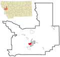
| and Billings, Montana. Missoula County, Montana Missoula (principal city) Bonner-West Riverside (Census-designated place) East Missoula (Census-designated... 7 KB (479 words) - 07:44, 9 May 2024 |
 | a census-designated place (CDP) in Missoula County, Montana, United States. It is part of the 'Missoula, Montana Metropolitan Statistical Area'. The... 7 KB (569 words) - 00:22, 15 March 2024 |
community and census-designated place in Missoula County, Montana, United States. Located along the Swan River and Montana Highway 83, Condon is situated between... 11 KB (431 words) - 02:42, 18 April 2024 |
several female students raped in Missoula, Montana, with many of the rapes linked in some way to the University of Montana and their football team. Krakauer... 8 KB (885 words) - 19:23, 27 November 2023 |
 | Clark Fork River (category Bodies of water of Missoula County, Montana) generally northwest across western Montana, passing south of the Garnet Range toward Missoula. Five miles east of Missoula, the river receives the Blackfoot... 19 KB (1,826 words) - 21:47, 12 August 2023 |
 | Homes is a census-designated place (CDP) in Missoula County, Montana, United States. It is part of the Missoula Metropolitan Statistical Area. The population... 7 KB (514 words) - 00:13, 15 March 2024 |
 | Wye is an unincorporated community in Missoula County, Montana, United States. It is part of the Missoula, Montana Metropolitan Statistical Area. The population... 6 KB (501 words) - 00:18, 15 March 2024 |
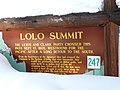 | the border between the states of Montana and Idaho, approximately forty miles (65 km) west-southwest of Missoula, Montana. The pass is the highest point... 9 KB (734 words) - 09:56, 21 November 2023 |
 | Evaro is a census-designated place (CDP) in Missoula County, Montana, United States, and part of the Missoula Metropolitan Statistical Area. It is located... 8 KB (591 words) - 00:25, 15 March 2024 |
 | located in central Montana and the vast plains area of eastern Montana, to larger western Montana cities such as Great Falls and Missoula. At its western... 27 KB (1,320 words) - 07:15, 9 February 2024 |
The culture of Missoula, Montana is influenced by the nearby University of Montana in art, sports, and music with the city's location in a mountain river... 28 KB (3,286 words) - 02:10, 13 July 2022 |
(Fort Ellis), el. 4,987 feet (1,520 m) Fort Fizzle (historical), Missoula County, Montana, 46°44′42″N 114°11′26″W / 46.74500°N 114.19056°W / 46.74500;... 18 KB (3,304 words) - 16:04, 27 March 2023 |
 | Bitterroot Valley (category Landforms of Missoula County, Montana) Commerce. (2014). 24 July 2014[permanent dead link] "Montana FWP: Grizzlies seen around Missoula". NBC Montana. August 2, 2023. Retrieved August 3, 2023. "Obituary:... 9 KB (999 words) - 09:09, 2 May 2024 |