 | Moses Coulee is a canyon in the Waterville plateau region of Douglas County, Washington. Moses Coulee is the second-largest and westernmost canyon of... 14 KB (1,545 words) - 05:43, 11 April 2024 |
 | Grand Coulee and Moses Coulee. Moses Coulee and Lenore Canyon, lower Grand Coulee, have hanging valleys, where pre-flood tributaries enter the coulees at... 6 KB (670 words) - 17:37, 23 January 2024 |
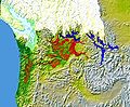
British Columbia. The Moses Coulee, Moses-Columbia, is an Ice Age Canyon (coulee) just south of the Columbia River west of Coulee City on U.S. Highway... 6 KB (653 words) - 06:56, 2 January 2024 |
 | diverted Columbia River – drained first through Moses Coulee and as the ice dam grew, later through the Grand Coulee. Eventually, water in Lake Missoula rose... 5 KB (566 words) - 14:19, 17 September 2023 |
 | Sims Corner Eskers and Kames (section Creation of the Foster Coulee, Moses Coulee, and Grand Coulee) Plateau highlands above the Grand Coulee and south to the head of Moses Coulee. In some areas north of the Grand Coulee they were as much as 3 km (10,000 feet)... 8 KB (753 words) - 05:40, 11 April 2024 |
characters Moses (surname), including a list of people Moses Coulee, Washington, United States Moses Lake, a lake in Washington, United States Moses Fork,... 3 KB (367 words) - 04:42, 9 December 2023 |
British Columbia. The Moses Coulee, Moses-Columbia, is an Ice Age Canyon (coulee) just south of the Columbia River west of Coulee City on U.S. Highway... 5 KB (690 words) - 04:18, 21 March 2024 |
 | boulders, covers most of the upper Moses Coulee. The melting glacier discharged both down Moses Coulee and into the Grand Coulee as is evident in the Sims Corner... 8 KB (783 words) - 05:38, 11 April 2024 |
 | Coulee Dam. Lake Columbia's overflow – the diverted Columbia River – drained first through Foster Coulee, and as the ice dam grew, then through Moses... 5 KB (447 words) - 14:43, 19 August 2023 |
 | natural to the area. Before the construction of Grand Coulee Dam on the Columbia River in 1941 and Moses Lake Army Air Base in 1942 the area was largely barren... 32 KB (3,131 words) - 19:12, 10 May 2024 |
 | replied Moses, "There are too many." Moses Lake, Moses Coulee, and the city of Moses Lake are named for Chief Moses. One of the middle schools in Moses Lake... 11 KB (1,430 words) - 01:37, 16 April 2024 |
 | County, flows through Moses Coulee then empties to Wanapum Lake on the Columbia River. The course of the creek through Moses Coulee displays an "outdoor... 3 KB (210 words) - 14:13, 7 February 2022 |
| and soil-free region of interconnected relict and dry flood channels, coulees and cataracts eroded into Palouse loess and the typically flat-lying basalt... 16 KB (1,818 words) - 10:37, 4 April 2024 |
 | Washington, vastly transforming the landscape by forming the Grand Coulee, Moses Coulee, the Channeled Scablands, Dry Falls, Palouse Falls and many similar... 9 KB (1,046 words) - 07:03, 6 May 2024 |
 | (2): 253–259. doi:10.4319/lo.1967.12.2.0253. Lillquis, Karl (2016). Moses Coulee to Chelan Field Trip, 12 June 2016. Ellensburg, Washington: Ellensburg... 30 KB (2,290 words) - 00:24, 16 January 2024 |
 | Grant County, Washington (redirect from Moses Lake, WA μSA) "The nation's leading potato producing county". Columbia River Grand Coulee Moses Lake Potholes Reservoir Soap Lake Ulysses S. Peak, unofficial name of... 18 KB (1,521 words) - 21:43, 26 April 2024 |
| the Waterville Plateau into Moses Coulee but later, when the Okanagon lobe blocked that route, eroding the Grand Coulee to discharge there as a substantially... 24 KB (2,983 words) - 12:41, 29 April 2024 |
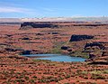
| Moses Coulee in the US showing multiple flood basalt flows of the Columbia River Basalt Group. The upper basalt is Roza Member, while the lower canyon... 42 KB (4,896 words) - 11:47, 19 April 2024 |
Beezley. The hills rise from the east bank of the Columbia River between Moses Coulee and Frenchman Gap. They extend about 25 miles (40 km) to Ephrata and... 14 KB (1,181 words) - 06:08, 10 April 2024 |
Foster Coulee is a coulee in Douglas County, Washington. Like the larger Moses Coulee nearby, it was formed during the Missoula Floods at the end of the... 5 KB (491 words) - 01:39, 17 May 2021 |
and Virginia Mississippi Gorge, Minnesota Mianus River Gorge, New York Moses Coulee, Washington McKittrick Canyon, Guadalupe Mountains National Park, Texas... 26 KB (2,188 words) - 11:31, 9 May 2024 |
 | of Devils Postpile National Monument near Yosemite National Park and Moses Coulee in the Channeled Scablands of Washington), with characteristic reddish-purple... 11 KB (1,188 words) - 09:24, 22 February 2024 |
Sinkiuse-Columbia (redirect from Columbia-Moses) River and centered on Moses Coulee. In 1870, Winans placed them "on the east and south sides of the Columbia River from the Grand Coulee down to Priest's Rapids... 6 KB (629 words) - 07:13, 2 January 2024 |
 | between Mesa and Moses Lake and as the Coulee Corridor Scenic Byway between Othello and Coulee City for passing through the Grand Coulee. SR 17 begins in... 30 KB (2,392 words) - 04:15, 11 May 2024 |
Boulder Park Drumheller Channels Ginkgo Petrified Forest Grand Coulee Mima Mounds Moses Coulee Nisqually Delta Sims Corner Eskers and Kames Steptoe and Kamiak... 7 KB (128 words) - 12:54, 25 May 2022 |
 | while the Snake River Plains propagated eastward. Geology portal Grand Coulee Channeled scablands Wallula Gap Interior Plateau Basin and Range Province... 36 KB (4,201 words) - 10:53, 29 April 2024 |
 | Three Devils Grade in Moses Coulee, Washington is part of the Columbia River Basalt Group LIP.... 42 KB (4,542 words) - 14:16, 25 March 2024 |
 | blocked Moses Coulee as well; the Columbia found the next lowest route through the region which was eroded to become the modern Grand Coulee. Flowing... 11 KB (1,313 words) - 18:14, 6 May 2024 |
was located about 7 miles (11 km) west of Coulee City, on the high ground between Moses Coulee and Grand Coulee. A post office called Baird was established... 4 KB (173 words) - 15:14, 24 February 2024 |
62 miles (97.56 km) of track cut through the southern portion of the Moses Coulee, snaked up Douglas Creek and made its way across the vast wheat fields... 5 KB (603 words) - 00:55, 5 March 2024 |