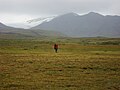
 | Mount Edziza Provincial Park is a provincial park in Cassiar Land District of northern British Columbia, Canada. It was established on 27 July 1972 to... 2 KB (134 words) - 16:34, 19 March 2024 |
 | Mount Edziza (/ədˈzaɪzə/), sometimes called Edziza Mountain or Edziza Peak, is a stratovolcano in Cassiar Land District of northwestern British Columbia... 61 KB (7,298 words) - 17:40, 11 April 2024 |
 | The Mount Edziza volcanic complex (/ədˈzaɪzə/; abbreviated MEVC) is a group of volcanoes and associated lava flows in northwestern British Columbia, Canada... 89 KB (9,987 words) - 01:01, 10 April 2024 |
The Mount Edziza volcanic complex (MEVC) in British Columbia, Canada, has a long history of volcanism that spans more than six million years. It occurred... 65 KB (8,979 words) - 22:59, 11 April 2024 |
 | – Mount Edziza Provincial Park Tenchen Glacier – Mount Edziza Provincial Park Tencho Glacier – Mount Edziza Provincial Park Tennaya Glacier – Mount Edziza... 6 KB (486 words) - 13:14, 19 March 2024 |
Telegraph Creek. It was established on 27 February 1972 along with Mount Edziza Provincial Park. Initially, the 101,171-hectare (249,999-acre) recreation area... 5 KB (460 words) - 21:45, 16 February 2024 |
| Formation was mapped as one of several geological formations of the Mount Edziza volcanic complex. It overlies at least four other geological formations... 22 KB (2,490 words) - 19:55, 10 April 2024 |
Stikine River. Kakiddi Creek forms the northeastern boundary of Mount Edziza Provincial Park which lies within the traditional territory of the Tahltan people... 8 KB (784 words) - 05:06, 9 January 2024 |
Gnu Butte (category Landforms of the Mount Edziza volcanic complex) on the Tahltan Highland between Mess Lake and Mowdade Lake in Mount Edziza Provincial Park. It bears a resemblance to flat-topped hills in parts of Africa... 3 KB (258 words) - 06:10, 11 January 2024 |
Artifact Creek (category Rivers of the Mount Edziza volcanic complex) Creek's watershed covers 42.5 km2 (16.4 sq mi), and is entirely in Mount Edziza Provincial Park. The creek's mean annual discharge is estimated at 1.62 m3/s... 6 KB (527 words) - 06:00, 9 January 2024 |
Cassiar Land District. From its source at Little Ball Lake in Mount Edziza Provincial Park, the Little Iskut River flows about 45 km (28 mi), generally... 9 KB (749 words) - 18:05, 28 March 2024 |
on the south side of Artifact Creek at the southeast end of Mount Edziza Provincial Park. It was named on January 2, 1980 by the Geological Survey of... 852 bytes (98 words) - 01:52, 15 February 2024 |
Shaman Creek (category Rivers of the Mount Edziza volcanic complex) Its watershed covers 153 km2 (59 sq mi), and is mostly within Mount Edziza Provincial Park. The watershed's land cover is classified as 44.9% conifer forest... 6 KB (494 words) - 21:12, 17 March 2024 |
straits of the Inside Passage. The Klastline River flows through Mount Edziza Provincial Park which lies within the traditional territory of the Tahltan people... 10 KB (1,116 words) - 05:55, 9 January 2024 |
Nido Creek (category Rivers of the Mount Edziza volcanic complex) watershed covers 19.2 km2 (7.4 sq mi), and is entirely within Mount Edziza Provincial Park and Tenh Dẕetle Conservancy. The watershed's land cover is classified... 6 KB (437 words) - 21:10, 17 March 2024 |
Stewbomb Creek (category Rivers of the Mount Edziza volcanic complex) Creek's watershed covers 88.9 km2 (34.3 sq mi), and is entirely in Mount Edziza Provincial Park. The creek's mean annual discharge is estimated at 3.48 m3/s... 6 KB (480 words) - 06:01, 9 January 2024 |
Tadekho Creek (category Rivers of the Mount Edziza volcanic complex) entirely in Mount Edziza Provincial Park. Only a small part of the upper reaches of one of the creek's southernmost tributaries extends outside the park boundary... 6 KB (500 words) - 05:27, 9 January 2024 |
 | Mount Robson Provincial Park is a provincial park in the Canadian Rockies with an area of 2,249 km2. The park is located entirely within British Columbia... 5 KB (430 words) - 05:58, 2 August 2023 |
Tenh Dẕetle Conservancy (redirect from Mount Edziza Conservancy) approximately 3,528 hectares (8,720 acres) along the eastern boundary of Mount Edziza Provincial Park. The Tenh Dẕetle Conservancy protects habitat for a variety of... 2 KB (114 words) - 02:45, 28 September 2023 |
Chakima Creek (category Rivers of the Mount Edziza volcanic complex) Its watershed covers 100 km2 (39 sq mi), and is mostly within Mount Edziza Provincial Park. The watershed's land cover is classified as 45.7% conifer forest... 7 KB (561 words) - 05:57, 9 January 2024 |
Sorcery Creek (category Rivers of the Mount Edziza volcanic complex) watershed covers 15.1 km2 (5.8 sq mi), and is entirely within Mount Edziza Provincial Park and Tenh Dẕetle Conservancy. The watershed's land cover is classified... 6 KB (404 words) - 05:10, 9 January 2024 |
Destell Pass (category Landforms of the Mount Edziza volcanic complex) southeastern end of Mount Edziza Provincial Park. Destell Pass has an elevation of 1,622 m (5,322 ft) and consists of a narrow rock cleft. Edziza obsidian of... 2 KB (217 words) - 04:30, 9 January 2024 |
Kitsu Creek (category Rivers of the Mount Edziza volcanic complex) Its watershed covers 72.6 km2 (28.0 sq mi), and is entirely in Mount Edziza Provincial Park. The watershed's land cover is classified as 42.5% barren, 28... 5 KB (403 words) - 05:26, 9 January 2024 |
More Creek (category Rivers of the Mount Edziza volcanic complex) northernmost part of which is within Mount Edziza Provincial Park. The watershed drains parts of the Mount Edziza volcanic complex. The watershed's land... 9 KB (849 words) - 05:39, 9 January 2024 |
Ball Creek (British Columbia) (category Rivers of the Mount Edziza volcanic complex) (132 sq mi), the upper part of which is within Mount Edziza Provincial Park. The watershed drains parts of the Mount Edziza volcanic complex. The watershed's land... 7 KB (544 words) - 05:40, 9 January 2024 |
Bourgeaux Creek (category Rivers of the Mount Edziza volcanic complex) Its watershed covers 104 km2 (40 sq mi), and is entirely in Mount Edziza Provincial Park. The watershed's land cover is classified as 37.7% barren, 29... 8 KB (677 words) - 06:01, 9 January 2024 |
Columbia Provincial parks: Stikine River Provincial Park and Mount Edziza Provincial Park (both located near Telegraph Creek) Great Glacier Provincial Park (100 km... 11 KB (857 words) - 01:57, 13 April 2024 |
Nagha Creek (category Rivers of the Mount Edziza volcanic complex) Its watershed covers 46.6 km2 (18.0 sq mi), and is entirely in Mount Edziza Provincial Park. The watershed's land cover is classified as 38.5% barren, 29... 6 KB (539 words) - 19:33, 10 March 2024 |
Raspberry Creek (British Columbia) (category Rivers of the Mount Edziza volcanic complex) herbaceous, and small amounts of other cover. Raspberry Creek is in Mount Edziza Provincial Park which lies within the traditional territory of the Tahltan people... 7 KB (565 words) - 06:08, 11 January 2024 |
Plumbing and Mechanical Officials IGC Centre, a lava dome in Mount Edziza Provincial Park, British Columbia, Canada Independent Garden Center Show or IGC... 3 KB (330 words) - 07:37, 6 September 2023 |