
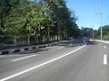
National Route 59 (N59) is a primary national route that forms part of the Philippine highway network, running from Antipolo, Rizal to Cubao, Quezon City...
4 KB (331 words) - 03:23, 19 April 2023
N59 may refer to: N59 road (Ireland) N59 highway (Philippines) HMS Ursula (N59), a submarine of the Royal Navy Nebraska Highway 59, in the United States...
268 bytes (69 words) - 17:49, 10 October 2022

Works and Highways (DPWH), its section from Katipunan Avenue to Sumulong Highway is a component of National Route 59 (N59) of the Philippine highway network...
13 KB (887 words) - 05:14, 27 April 2024
New Zealand State Highway 59 N59 highway (Philippines) British A59 Interstate 59 U.S. Route 59 Alabama State Route 59 Arkansas Highway 59 California State...
6 KB (395 words) - 23:09, 4 April 2024
Department of Public Works and Highways (DPWH), it is a component of National Route 59 (N59) of the highway in the Philippine highway network from its intersection...
4 KB (377 words) - 00:39, 19 April 2023

N170 in Diliman, Quezon City N172 / N174 in Diliman, Quezon City N180 / N59 in Cubao, Quezon City N185 near Camp Aguinaldo, Quezon City N184 / N60 at...
40 KB (3,139 words) - 11:59, 18 April 2024
The Philippine highway network is a network of national roads owned and maintained by the Department of Public Works and Highways (DPWH) and organized...
108 KB (869 words) - 12:42, 19 May 2024

The N59 road is a national secondary road in Ireland. It commences in County Sligo, south of Sligo Town at the Belladrehid interchange with the N4 north...
5 KB (492 words) - 23:35, 26 April 2024
Asian Highway Network Arab Mashreq International Road Network Alaska Highway International E-road network Pan-American Highway Trans-African Highway network...
7 KB (491 words) - 13:56, 7 April 2024
(Filipino: Abenida Imelda), is a four-lane major road which connects Marcos Highway to Ortigas Avenue Extension. It is one of the busiest roads in Cainta,...
2 KB (124 words) - 10:36, 29 January 2023

village and townland in County Sligo, Ireland. It is situated on the N59 national highway section between Ballina, County Mayo, and Sligo Town, near the junction...
3 KB (139 words) - 08:24, 14 October 2021
Avenue (N180) and eastward as a continuation of Aurora Boulevard (N59). The highway's section from EDSA in Quezon City to Recto Avenue/Mendiola Street...
7 KB (546 words) - 05:31, 15 October 2022
eastward to Rizal province as Marikina-Infanta Highway (or still more commonly known as Marcos Highway). The entire span of the road and its continuations...
14 KB (825 words) - 18:55, 30 April 2024

of Public Works and Highways. Retrieved February 24, 2021. "Road and Bridge Inventory". Department of Public Works and Highways. Retrieved January 31...
7 KB (311 words) - 14:08, 18 May 2024
Katipunan/Aurora Flyover, classified as a tertiary road that carries traffic crossing N59. Later, it follows the Libis Tunnel, Libis Flyover, and the at-grade section...
4 KB (323 words) - 13:13, 21 November 2023
N170 in Diliman, Quezon City N172 / N174 in Diliman, Quezon City N180 / N59 in Cubao, Quezon City N185 near Camp Aguinaldo, Quezon City N184 / N60 in...
50 KB (4,148 words) - 23:05, 13 April 2024
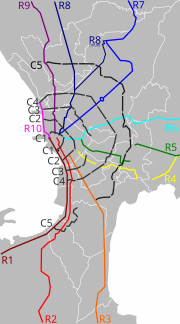
National Route 11 (N11) and National Route 129 (N129) of the Philippine highway network, respectively, and Circumferential Road 5 (C-5) of Manila's arterial...
22 KB (1,662 words) - 01:24, 22 November 2023

and Sligo in Ireland. It connects the N4 road near Boyle to the N26 and N59 roads in Ballina, 66 kilometres (41 mi) away (map). The government legislation...
4 KB (304 words) - 08:40, 13 October 2022
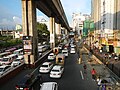
its acronym EDSA (Tagalog: [ˈɛdsa]), is a limited-access circumferential highway around Manila, the capital city of the Philippines. It passes through 6...
63 KB (5,005 words) - 23:48, 10 May 2024

Santa Rosa–Tarlac Road (redirect from N58 highway (Philippines))
Rosa–Tarlac Road, signed as National Route 58 (N58) of the Philippine highway network, is a 39 kilometers (24 miles) major primary road in the provinces...
5 KB (267 words) - 15:41, 18 May 2024

road becomes the Marcos Highway (Marikina–Infanta Highway) after crossing the Katipunan Avenue (C-5). The portion of Marcos Highway that is a part of the...
4 KB (325 words) - 05:23, 25 January 2024
List of roads in Metro Manila (section Highway network)
only covers roads that are listed on the Department of Public Works and Highways's Infrastructure Atlas, as well as the previous circumferential and radial...
70 KB (2,132 words) - 11:06, 30 April 2024

High School WILL School of Antipolo A significant part of the N59/R-6 Marikina–Infanta Highway runs through Antipolo in a general west-east direction, serving...
49 KB (4,548 words) - 03:04, 10 April 2024

U.S. Route 160 in Arizona (category U.S. Highways in Arizona)
Immediately east of US 163, the highway passes the southern edge of Kayenta Airport. At the intersection with Navajo Route 59 (N59) near Church Rock Valley,...
14 KB (1,447 words) - 01:39, 16 May 2024

following major roads and thoroughfares: N59/R-6: Marikina–Infanta Highway (known as Marilaque Highway and Marcos Highway) N11: FVR (Fidel V. Ramos) Road (known...
92 KB (8,605 words) - 11:34, 30 April 2024

Metro Manila, Philippines The bridge is part of the Marcos Highway (Marikina–Infanta Highway). It consists of an inner bridge and an outer bridge. The...
6 KB (431 words) - 08:18, 12 August 2023

N29 N30 N31 N32 N33 N40 N50 Secondary roads N51 N52 N53 N54 N55 N56 N58 N59 N60 N61 N62 N63 N65 N66 N67 N68 N69 N70 N71 N72 N73 N74 N75 N76 N77 N78 N80...
1 KB (55 words) - 17:10, 18 April 2023

N29 N30 N31 N32 N33 N40 N50 Secondary roads N51 N52 N53 N54 N55 N56 N58 N59 N60 N61 N62 N63 N65 N66 N67 N68 N69 N70 N71 N72 N73 N74 N75 N76 N77 N78 N80...
3 KB (165 words) - 04:51, 19 February 2023

Zierikzee N58 Flushing - Middelburg - Goes - Kruiningen - Bergen op Zoom N59 Zierikzee - Bruinisse - Sint Philipsland - Steenbergen N60 Goes - Terneuzen...
36 KB (1,351 words) - 04:22, 1 January 2021

carriageway relief road around Westport and the realignment of 2.5km of the N59 road north of the town. An Bórd Pleanala approved the route in May 2014....
16 KB (1,635 words) - 21:33, 12 February 2024