 | According to the website (https://worldwind.arc.nasa.gov/), "WorldWind is an open source virtual globe API. WorldWind allows developers to quickly and... 20 KB (1,970 words) - 05:12, 6 April 2024 |
| Globe 98, followed by Cosmi's 3D World Atlas in 1999. The first widely publicized online virtual globes were NASA WorldWind (released in mid-2004) and Google... 8 KB (974 words) - 08:19, 28 December 2023 |
 | Landsat 7 (category NASA satellites orbiting Earth) and data from Landsat 7 is collected and distributed by the USGS. The NASA WorldWind project allows 3D images from Landsat 7 and other sources to be freely... 13 KB (1,359 words) - 15:51, 2 March 2024 |
 | 1975, NASA managed a program for the United States Department of Energy and the United States Department of Interior to develop utility-scale wind turbines... 22 KB (2,666 words) - 22:58, 29 July 2023 |
 | nearly devoid of vegetation. A superimposition of the map with current NASA WorldWind satellite images shows the extent of flooding in the area of the salient... 7 KB (635 words) - 15:17, 29 January 2024 |
created in 2010 by the Air Force Research Laboratory, and based on the NASA WorldWind Mobile codebase its development and deployment grew slowly, then rapidly... 20 KB (1,961 words) - 11:10, 5 April 2024 |
content management system GPS eXchange Format Keyhole satellite series NASA WorldWind Point of interest SketchUp file formats The Blue Marble Waypoint Wikimapia... 8 KB (779 words) - 04:59, 7 March 2024 |
 | is fertile, lake with high water, Snow on Mount Kyllini (2.374 m), NASA WorldWind (8 km) Trees at the lake Oligyrtos Mountain, 100% forest, high water... 3 KB (305 words) - 22:46, 4 January 2024 |
 | Kalahari Desert (category Articles with WorldCat Entities identifiers) Convergence Zone (ITCZ)/"Continental Trade winds". The ITCZ is the meeting area of the boreal trade winds with their austral counterparts what meteorologists... 22 KB (2,461 words) - 21:21, 1 April 2024 |
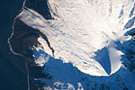 | Big Ben is the large massif to the bottom right (southeast) of this image of Heard Island, from NASA WorldWind... 5 KB (421 words) - 00:44, 7 May 2024 |
 | Oblique Landsat image draped over digital elevation data (×5 vertical exaggeration), Spider crater; screen capture from NASA WorldWind... 4 KB (365 words) - 00:30, 7 May 2024 |
CEO of EarthX, a data visualization and mapping company based on NASA’s World Wind Project. He is chairman of Synergetic Press based in New Mexico, and... 8 KB (651 words) - 19:44, 19 February 2024 |
AFRC GRC MSFC ARC LaRC JSC SSC There are NASA facilities across the United States and around the world. NASA Headquarters in Washington, DC provides overall... 29 KB (2,518 words) - 16:57, 26 April 2024 |
 | Moderate Resolution Imaging Spectroradiometer (category NASA) (L3) datasets are available from NASA, as processed by the Collection 5 software. Imaging spectroscopy NASA WorldWind Aqua (satellite) Terra (satellite)... 15 KB (1,005 words) - 13:00, 30 April 2024 |
 | Ames Research Center (redirect from NASA Ames Wind Tunnel Historic District) The Ames Research Center (ARC), also known as NASA Ames, is a major NASA research center at Moffett Federal Airfield in California's Silicon Valley. It... 40 KB (4,784 words) - 18:32, 23 February 2024 |
 | collector for 80 million US dollars. Color coding in data visualization NASA WorldWind uses several false-color satellite image layers List of software palettes... 27 KB (2,239 words) - 09:37, 31 March 2024 |
2012-09-30. "Get Inspired". earth.google.com. "Demos-WorldWind Java/NASA WorldWind". worldwind.arc.nasa.gov. Archived from the original on 2009-10-24. Retrieved... 28 KB (3,068 words) - 12:27, 27 April 2024 |
 | Atlas (redirect from World atlas) Manifold – Topological space that locally resembles Euclidean space NASA World Wind – Open-source virtual globePages displaying short descriptions of redirect... 12 KB (1,327 words) - 22:35, 7 May 2024 |
 | Sahara (category Geography of the Arab world) minor part, but many of the sand dunes are over 180 metres (590 ft) high. Wind or rare rainfall shape the desert features: sand dunes, dune fields, sand... 102 KB (11,695 words) - 12:30, 12 May 2024 |
 | Langley Research Center (redirect from NASA langley) more than 40 wind tunnels to study and improve aircraft and spacecraft safety, performance, and efficiency. Between 1958 and 1963, when NASA (the successor... 20 KB (2,066 words) - 00:32, 3 May 2024 |
The National Aeronautics and Space Administration (NASA; /ˈnæsə/) is an independent agency of the U.S. federal government responsible for the civil space... 223 KB (20,750 words) - 14:03, 14 May 2024 |
 | Canada, and is 775 metres (2,543 ft) long. Satellite photos provided by NASA WorldWind show the dam did not exist in 1975, but it appeared in subsequent images... 29 KB (3,130 words) - 02:50, 10 April 2024 |
 | has become a standard for global raster datasets, such as Celestia, NASA World Wind, the USGS Astrogeology Research Program, and Natural Earth, because... 7 KB (784 words) - 10:16, 18 November 2023 |
 | kilometers (18,300 miles) from the planet's surface. The original image (NASA designation AS17-148-22727) was taken by either Ron Evans or Harrison Schmitt... 33 KB (3,430 words) - 10:00, 5 May 2024 |
 | accessed from Shompole Conservancy Kenya. Lake Natron as seen on NASA's World Wind program The lake with flamingos Ol Doinyo Lengai seen from Lake Natron... 12 KB (1,329 words) - 18:06, 4 May 2024 |
licensing of NASA patents, use of NASA facilities, technical assistance from NASA personnel, or data from NASA research. Information on new NASA technology... 49 KB (5,493 words) - 14:11, 7 February 2024 |
 | demand for a Java-based version was very little. This may be because NASA's WorldWind also has an open source Java version. So most people wanted to use... 3 KB (327 words) - 00:48, 30 March 2023 |
Google Earth Google Maps NASA World Wind Official website Press release of the IGN Geoportail plugin for NASA World Wind adds 3D navigation to geoportail... 5 KB (538 words) - 15:28, 5 February 2023 |
 | Oblique Landsat image of Oasis crater draped over digital elevation model (x5 vertical exaggeration); screen capture from NASA World Wind... 3 KB (181 words) - 06:53, 11 March 2024 |
as COLLADA Open Wonderland OpenSimulator Mac OS X 10.6+'s Preview NASA World Wind Second Life SketchUp - import .dae files. Systems Tool Kit (STK) -... 11 KB (1,017 words) - 04:48, 18 January 2024 |