 | The northern boundary of the U.S. state of Massachusetts adjoins two other states: Vermont and New Hampshire. The majority of the boundary is roughly a... 8 KB (1,097 words) - 05:10, 28 February 2024 |
 | surprising manner, by declaring "that the northern boundary of Massachusetts be a similar curve line pursuing the course of the Merrimack River at three miles... 147 KB (18,119 words) - 20:34, 15 February 2024 |
 | Portsmouth Numerous towns were ceded to New Hampshire after the Northern boundary of Massachusetts was defined by royal decree in 1741: Dunstable North Naticook... 117 KB (1,071 words) - 21:13, 5 May 2024 |
 | Narragansett Bay. List of mountains in Massachusetts List of Massachusetts rivers Massachusetts#Geography Northern boundary of Massachusetts "Population, Housing... 50 KB (5,694 words) - 01:39, 9 April 2024 |
 | parts of other towns as well. Increases in population leading to subsections becoming independent towns and the delineation of the northern boundary of Massachusetts... 16 KB (1,691 words) - 14:06, 2 May 2024 |
 | part of the border between Massachusetts and New Hampshire, which runs parallel to the river, three miles north of it (see Northern boundary of Massachusetts... 10 KB (1,180 words) - 17:52, 9 February 2024 |
 | Historical Society building. In 1741, with the fixing of the Northern boundary of Massachusetts, most of this new north parish was removed from Methuen and... 28 KB (3,230 words) - 18:43, 27 April 2024 |
 | delineating the northern boundary of Massachusetts, which was frequently disputed between the Province of Massachusetts Bay and the Province of New Hampshire... 4 KB (421 words) - 05:52, 7 November 2023 |
| Massachusetts (/ˌmæsəˈtʃuːsɪts/ , /-zɪts/ MASS-ə-CHOO-sits, -zits; Massachusett: Muhsachuweesut [məhswatʃəwiːsət]), officially the Commonwealth of Massachusetts... 245 KB (21,419 words) - 01:57, 5 May 2024 |
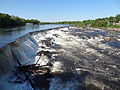
 | marked the difference in definition of the northern boundary of Massachusetts. This point is 3 miles (5 km) due north of Pawtucket Falls in Lowell, and marks... 16 KB (1,489 words) - 17:03, 3 May 2024 |
 | The U.S. state of Massachusetts has 14 counties, though eight of these fourteen county governments were abolished between 1997 and 2000. The counties... 20 KB (1,080 words) - 14:19, 21 April 2024 |
42nd parallel north (redirect from 42° northern latitude) forms most of the New York–Pennsylvania border, although due to imperfect surveying in 1785–1786, this boundary wanders around on both sides of the true... 14 KB (529 words) - 22:08, 17 June 2023 |
 | Hudson, New Hampshire (category 1673 establishments in the Massachusetts Bay Colony) Merrimack River became the town of Nottingham, Massachusetts. Nine years later, the northern boundary of Massachusetts was finally officially established... 28 KB (2,640 words) - 14:30, 3 May 2024 |
 | Aroostook War (redirect from Northeastern Boundary Dispute) determine the boundary between British North America (Quebec and New Brunswick) and the United States. The Commonwealth of Massachusetts thereafter began... 29 KB (3,688 words) - 01:40, 13 April 2024 |
 | The Province of Massachusetts Bay was a colony in New England which became one of the thirteen original states of the United States. It was chartered on... 43 KB (5,122 words) - 12:38, 5 May 2024 |
 | western edge of the peninsula (cape) and the Bourndale Road forming the northern boundary to the cape. Bourne is the site of the Massachusetts Maritime Academy... 31 KB (2,984 words) - 14:00, 2 May 2024 |
 | Walking Tour, Massachusetts Department of Conservation and Recreation. For a map that depicts Lake Hitchcock's boundary Western Massachusetts and in North... 25 KB (3,226 words) - 22:39, 3 May 2024 |
 | of Massachusetts at Wikimedia Commons Detailed map of Massachusetts area codes (pdf), Office of the Secretary of the Commonwealth of Massachusetts NANPA... 4 KB (160 words) - 04:34, 14 February 2024 |
 | The Massachusetts Bay Colony (1628–1691), more formally the Colony of Massachusetts Bay, was an English settlement on the east coast of North America... 80 KB (9,509 words) - 17:09, 1 May 2024 |
 | as historical, legal, and census boundaries, such as the counties of Rhode Island, as well as eight of Massachusetts' 14 counties. On June 6, 2022, the... 327 KB (1,443 words) - 15:39, 25 April 2024 |
 | Map all coordinates in "Boundary markers of the original District of Columbia" using OpenStreetMap Download coordinates as: KML GPX (all coordinates) GPX... 95 KB (7,254 words) - 01:32, 18 April 2024 |
 | U.S. Route 3 (redirect from Route US 3 (Massachusetts)) Lake, where it connects to Quebec Route 257. Massachusetts Route 3 connects to the southern terminus of US 3 in Cambridge and continues south to Cape... 56 KB (3,208 words) - 03:50, 3 May 2024 |
 | Boston (redirect from Capital of Massachusetts) /ˈbɔːstən/), officially the City of Boston, is the capital and most populous city in the Commonwealth of Massachusetts in the United States. The city serves... 227 KB (19,401 words) - 18:28, 6 May 2024 |
 | Parallel 36°30′ north (category Lists of coordinates) slavery in all of the United States. The gap between the northern boundary of Texas on the parallel 36°30′ north and the southern boundaries of Kansas and... 15 KB (1,325 words) - 06:25, 2 March 2024 |
Tri-States Monument ... this small granite slab serves as both the northern end of our boundary with Pennsylvania and the northwestern end with New York. "North... 19 KB (639 words) - 18:47, 1 March 2024 |
 | itself, long considered the northern boundary of the downtown as well as home of Washington's Embassy Row. Massachusetts Avenue is tied with Pennsylvania... 18 KB (1,522 words) - 07:29, 12 April 2024 |
 | the northern to the southern border of the state. The geographic center of Massachusetts is in Rutland. Worcester County is one of two Massachusetts counties... 46 KB (2,801 words) - 15:39, 2 May 2024 |
 | Massachusett (redirect from Massachusetts (tribe)) In 1628, the Massachusetts Bay Colony was legally established, with a claim over the lands north of the Plymouth Colony. The boundary between the two... 51 KB (6,002 words) - 02:27, 23 April 2024 |
 | Massachusetts is home to many listings on the National Register of Historic Places. This list encompasses those locations that are located north of the... 61 KB (254 words) - 15:52, 14 January 2024 |
 | Bay Colony. The land was originally granted as separate from Massachusetts, but boundary disputes among the settlers led to their petitioning to join... 4 KB (381 words) - 02:48, 21 October 2021 |