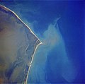
Ocracoke Island Airport (FAA LID: W95) is a public use airport located one nautical mile (2 km) east of the central business district of Ocracoke, a town... 4 KB (272 words) - 22:59, 24 February 2024 |
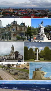
 | Ocracoke (/ˈoʊkrəkoʊk/ OH-kruh-kohk) is a census-designated place (CDP) and unincorporated town located at the southern end of Ocracoke Island, located... 44 KB (3,855 words) - 15:08, 14 March 2024 |
 | largest paved airstrip on the Island at Billy Mitchell Airport. Hatteras Village, terminus of the ferry to Ocracoke Island. As there are no incorporated... 17 KB (1,459 words) - 04:19, 3 March 2024 |
 | list of airports in North Carolina (a U.S. state), grouped by type and sorted by location. It contains all public-use and military airports in the state... 29 KB (562 words) - 04:38, 1 May 2024 |
W95 may refer to: Ocracoke Island Airport, in Hyde County, North Carolina, United States Truncated great icosahedron Windows 95, an operating system W95... 241 bytes (59 words) - 04:49, 28 September 2023 |
 | Hatteras, North Carolina (category Hatteras Island) Mitchell Airport. The Village is also home to the Hatteras-Ocracoke Ferry terminal which is the only way for people to access Ocracoke Island from Hatteras... 13 KB (901 words) - 00:16, 6 August 2023 |
 | some relict features indicative of its origins. The dialect is like the Ocracoke Brogue, sometimes referred to as the Outer Banks Brogue. The 1940 Maryland... 19 KB (1,911 words) - 03:38, 15 August 2023 |
 | Camp Mackall (category Airports in North Carolina) April 18, 2024 Resources for this U.S. military airport: FAA airport information for HFF AirNav airport information for KHFF ASN accident history for HFF... 6 KB (542 words) - 06:26, 5 January 2024 |
 | Dare County Regional Airport, general aviation airport First Flight Airport, inside Wright Brothers National Memorial Hatteras–Ocracoke Ferry (to Hyde County)... 24 KB (1,701 words) - 14:21, 27 April 2024 |
 | Cape Hatteras (category Hatteras Island) National Seashore protects parts of three barrier islands: Bodie Island, Hatteras Island, and Ocracoke Island. Beach and sound access ramps, campgrounds, nature... 21 KB (1,935 words) - 22:38, 6 May 2024 |
 | Simmons Army Airfield (category Airports in North Carolina) Army Airfield (IATA: FBG, ICAO: KFBG, FAA LID: FBG) is a military use airport located in Cumberland County, North Carolina, United States. It is located... 8 KB (857 words) - 16:43, 12 February 2024 |
 | Hurricane Maria (category 2017 in Saba (island)) visitors were ordered to evacuate Hatteras and Ocracoke islands. Ferry service between Ocracoke and Cedar Island was suspended the evening of September 25... 230 KB (20,462 words) - 04:23, 29 April 2024 |
 | Marine Corps Outlying Field Camp Davis (category Airports in North Carolina) Corps Outlying Field (MCOLF) Camp Davis (FAA LID: 14NC) is a military use airport northeast of the central business district of Holly Ridge, in Onslow County... 7 KB (676 words) - 03:14, 2 March 2023 |
Marine Corps Outlying Field Atlantic (category Airports in North Carolina) (12NC) Resources for this airport: FAA airport information for 12NC AirNav airport information for 12NC FlightAware airport information and live flight... 2 KB (72 words) - 03:16, 3 March 2024 |
 | Hurricane Isaias (section Antillean Islands) "Storm Surge Warning and Tornado Watch in effect for Hatteras and Ocracoke islands". Island Free Press. August 4, 2020. Archived from the original on September... 117 KB (10,239 words) - 00:07, 6 May 2024 |
 | Outer Banks of North Carolina, United States: one on Ocracoke Island and one on Hatteras Island in the town of Buxton, are owned by the United Kingdom... 98 KB (11,760 words) - 06:21, 10 May 2024 |
 | United States Coast Guard Air Station co-located at Elizabeth City Regional Airport in Elizabeth City, North Carolina, along the Pasquotank River near the... 7 KB (725 words) - 16:59, 9 May 2024 |
 | Marine Corps Auxiliary Landing Field Bogue (category Airports in North Carolina) Field Bogue. Resources for this U.S. military airport: FAA airport information for NJM AirNav airport information for KNJM NOAA/NWS latest weather observations... 10 KB (1,080 words) - 01:56, 4 June 2023 |
 | Inés Island Desolación Island Dawson Island Aracena Island Clarence Island Carlos Island Wickham Island Except Dawson Island, which had a population... 41 KB (3,540 words) - 03:35, 19 April 2024 |
Alexandria Bay, New York (section Airport) Economic Complexity". "Maxson Airfield - Alexandria Bay - Thousand Islands Destination Airport". Maxson Airfield. Archived from the original on November 8,... 16 KB (1,397 words) - 17:33, 26 October 2023 |
Marine Corps Outlying Field Oak Grove (category Airports in North Carolina) Marine Corps Outlying Field Oak Grove is an auxiliary airport of the United States Marine Corps located near Pollocksville, North Carolina. It was opened... 2 KB (193 words) - 03:16, 3 March 2024 |
 | List of New England hurricanes (redirect from Hurricanes in Rhode Island) England states. September 24–25, 1785 – A hurricane which made landfall near Ocracoke, North Carolina, impacted southern New England. Based on known observations... 89 KB (8,912 words) - 01:49, 2 November 2023 |
List of beaches in the United States (category Beaches of Rhode Island) Beach Long Beach Hatteras Nags Head North Topsail Beach Oak Island Ocean Isle Beach Ocracoke Pine Knoll Shores Portsmouth Rodanthe Salter Path Salvo Southern... 29 KB (1,573 words) - 20:29, 20 April 2024 |
 | Hurricane Joaquin (category 2015 in the Turks and Caicos Islands) Maryland, New Jersey, North Carolina, and South Carolina respectively. Ocracoke Island, North Carolina, was placed under a mandatory evacuation at 3:00 p... 73 KB (6,914 words) - 20:13, 12 April 2024 |
 | Effects of Hurricane Isabel in North Carolina (redirect from Little Hatteras Island) with flooding in Ocracoke reportedly being up to waist-high. The high waters washed out a 2,000 feet (610 m) portion of Hatteras Island between Hatteras... 25 KB (2,775 words) - 02:23, 24 November 2023 |
 | Hurricane Sandy (category 2012 in Rhode Island) mountain snow affected the state through October 30. Ocracoke and Highway 12 on Hatteras Island were flooded with up to 2 feet (0.6 m) of water, closing... 214 KB (19,346 words) - 19:11, 3 May 2024 |
 | much change to the Island City. During World War II, the Galveston Municipal Airport, predecessor to Scholes International Airport, was re-designated... 148 KB (13,931 words) - 03:31, 14 April 2024 |
Isabel & Sidersky, Robyn (July 27, 2017). "More than 7,000 on Hatteras and Ocracoke are without power, and a fix could take days or weeks". The Virginian-Pilot... 160 KB (16,287 words) - 07:13, 24 April 2024 |
 | Hurricane Dorian (category Natural disasters in Prince Edward Island) airlifted off the island to shelters on the mainland while food and water were brought in to residents on the island. NC 12 along Ocracoke Island suffered damage... 169 KB (14,431 words) - 07:00, 3 May 2024 |
 | about 2,000 men (about 1,200 infantry and 800 cavalry) were camped at Ten Islands on the Coosa River, near the present day Neely Henry Dam. The Creeks under... 5 KB (506 words) - 21:14, 28 February 2024 |