 | hazard index for Ollagüe. A seismometer array was deployed in 2010–2011. Future eruptions of Ollagüe may threaten the town of Ollague 12 kilometres (7... 61 KB (7,556 words) - 08:40, 19 March 2024 |
Ollagüe Airport (Spanish: Aeropuerto de Ollagüe, ) is an extremely high elevation airport in the Chilean altiplano. It is 1 kilometre (0.6 mi) east of... 2 KB (97 words) - 03:24, 28 March 2023 |
 | (Spanish-Aymara-Aymara-Spanish dictionary) OpenStreetMap - Ollagüe Official website Mineros del Alto Cielo: Historical Archaeology Project Ollagüe Google Maps... 7 KB (342 words) - 22:38, 7 October 2023 |
 | Bolivia-Chile passes Visviri Chungara–Tambo Quemado Colchane–Pisiga Salar de Ollagüe Portezuelo de Chaxas Portezuelo del Cajón Argentina-Chile passes Jama Sico... 59 KB (6,858 words) - 10:44, 23 April 2024 |
 | situated between Uyuni and Coipasa. Its most prominent summit is the Ollagüe (Ullawi) volcano on the border with Chile. The southern section, characterized... 4 KB (349 words) - 01:30, 1 February 2024 |
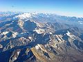
 | stratovolcano considered extinct. View of Licancabur. The summit area is in Chile. Ollagüe seen from Bolivia. Acotango volcano seen from Chile. List of glaciers in... 11 KB (258 words) - 19:34, 9 November 2023 |
Licancabur Linzor Llullaillaco Minchincha Miñiques Miño Miscanti Olca Ollagüe Palpana Paranal Paruma Pular Puntas Negras Putana Quimal Sairecabur Salín... 9 KB (268 words) - 14:17, 13 November 2023 |
 | in the Ñuñoa district of Santiago, Chile. Designated by the DINA as "Ollagüe Barracks," this was a transit site for people illegally detained during... 10 KB (1,022 words) - 21:19, 11 April 2024 |
 | censuses, the population grew by 14.9% (18,610 persons). Calama (capital) Ollagüe San Pedro de Atacama "Territorial division of Chile" (PDF) (in Spanish)... 5 KB (173 words) - 20:10, 19 April 2022 |
 | town. It is located 230 km southeast of Iquique and 118 km northwest of Ollagüe, in the Tarapacá Region, Chile. It is located on the edge of the old Inca... 3 KB (279 words) - 16:00, 9 May 2023 |
 | Bolivia-Chile passes Visviri Chungara–Tambo Quemado Colchane–Pisiga Salar de Ollagüe Portezuelo de Chaxas Portezuelo del Cajón Argentina-Chile passes Jama Sico... 5 KB (510 words) - 00:57, 6 May 2023 |
Volcano 5,890 19,324 Bolivia/Chile Falso Azufre 5,890 19,324 Argentina/Chile Ollagüe 5,868 19,252 Bolivia/Chile Taapaca 5,860 19,226 Chile San José 5,856 19... 36 KB (59 words) - 23:54, 30 March 2024 |
 | by road to Oruro - La Paz, Sucre, Villazón (border with Argentina) and Ollagüe, Chile. The city is also served by the Joya Andina Airport. Currently,... 13 KB (657 words) - 18:45, 28 January 2024 |
 | Calama Calama Ayquina Caspana Lasana San Francisco de Chiu Chiu Toconce Ollagüe San Pedro de Atacama Socaire Toconao Tocopilla Tocopilla Tocopilla María... 14 KB (1,253 words) - 01:21, 16 April 2024 |
claims in the Antarctic. Parinacota and Chungará Lake Licancabur's summit Ollagüe seen from Bolivia Miscanti and Laguna Miscanti Satellite image of Villarrica... 39 KB (596 words) - 12:01, 17 January 2024 |
 | electoral district, (together with Tocopilla, María Elena, Calama and Ollagüe). The commune is represented in the Senate by Alejandro Guillier Álvarez... 14 KB (1,169 words) - 13:34, 27 February 2024 |
 | of the population is a Latin American foreigner, with communes such as Ollagüe (31%), Mejillones (16%), Sierra Gorda (16%) and Antofagasta (11%), with... 54 KB (5,049 words) - 07:27, 3 May 2024 |
 | of the 3rd electoral district, (together with Tocopilla, María Elena, Ollagüe and San Pedro de Atacama). The commune is represented in the Senate by... 19 KB (1,440 words) - 12:10, 1 February 2024 |
 | Bolivia-Chile passes Visviri Chungara–Tambo Quemado Colchane–Pisiga Salar de Ollagüe Portezuelo de Chaxas Portezuelo del Cajón Argentina-Chile passes Jama Sico... 1 KB (59 words) - 20:36, 19 June 2019 |
 | of the population is a Latin American foreigner, with communes such as Ollagüe (31%), Mejillones (16%), Sierra Gorda (16%) and Antofagasta (11%), with... 81 KB (4,835 words) - 20:44, 4 May 2024 |
within the administrative boundaries of two Chilean cities: Calama and Ollagüe. Data from the digital elevation models TanDEM-X yields the 5988 metre... 3 KB (206 words) - 16:11, 23 November 2023 |
 | Bolivia-Chile passes Visviri Chungara–Tambo Quemado Colchane–Pisiga Salar de Ollagüe Portezuelo de Chaxas Portezuelo del Cajón Argentina-Chile passes Jama Sico... 2 KB (273 words) - 23:02, 23 January 2024 |
 | part of the 3rd electoral district, (together with María Elena, Calama, Ollagüe and San Pedro de Atacama). The commune is represented in the Senate by... 11 KB (858 words) - 21:53, 20 February 2024 |
 | Alto Loa is located at 3000 metres elevation between the communes of Ollagüe and Calama, 215 kilometres northeast of Antofagasta. The total surface... 8 KB (759 words) - 16:29, 11 December 2023 |
| Quemado Acotango Quimsa Chata Lauca River Isluga River Sillajhuay Olca Ollagüe Pass Ollagüe Inacaliri Silala River Licancabur Portezuelo del Cajón Zapaleri... 5 KB (313 words) - 11:40, 4 June 2022 |
 | relatively close to the Salar de Chiguana. It is also located 6 km east of Ollagüe, another extinct ultra prominent peak on the Chile-Bolivia border. Due... 3 KB (243 words) - 21:26, 13 December 2023 |
 | role. Other volcanoes in the region with sector collapses are: Lastarria, Ollague, San Pedro, Socompa, and Tata Sabaya. The Mellado and Cerro Rosado volcanoes... 103 KB (11,587 words) - 08:43, 25 April 2024 |
 | border in this area is a straight line that runs from Cerro Araral to Ollagüe, leaving Cerro Cañapa completely in Bolivian territory. The mountain forms... 3 KB (309 words) - 08:05, 30 January 2024 |
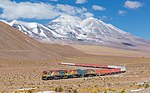 | Chilean port of Antofagasta. It proceeded up the front range of the Andes to Ollagüe on the Bolivian border, requiring a notable piece of civil engineering... 13 KB (1,559 words) - 07:38, 2 February 2024 |
 | 296,905 372,325 link El Loa San Pedro de Atacama 23,439 4,969 7,212 link Ollagüe 2,964 318 315 link Calama 15,597 138,402 173,691 link Tocopilla Tocopilla... 67 KB (384 words) - 01:55, 19 December 2023 |