 | The Ordnance Survey (OS) is the national mapping agency for Great Britain. The agency's name indicates its original military purpose (see ordnance and... 83 KB (8,487 words) - 16:25, 23 April 2024 |
Ordnance Survey Ireland (OSI; Irish: Suirbhéireacht Ordanáis Éireann) was the national mapping agency of the Republic of Ireland. It was established on... 13 KB (1,455 words) - 11:18, 26 April 2024 |
 | The Ordnance Survey National Grid reference system (OSGB), also known as British National Grid (BNG), is a system of geographic grid references used in... 19 KB (2,130 words) - 10:22, 14 April 2024 |
 | Ordnance Survey Ordnance Survey of Northern Ireland United States The National Geodetic Survey (NGS; formerly United States Coast and Geodetic Survey) The... 10 KB (1,049 words) - 17:22, 24 November 2023 |
 | An ordnance datum (OD) is a vertical datum used by an ordnance survey as the basis for deriving altitudes on maps. A spot height may be expressed as above... 7 KB (777 words) - 17:44, 27 March 2024 |
the basis for deriving altitudes on maps Ordnance Survey, the national mapping agency for Great Britain Ordnance Corps (disambiguation) This disambiguation... 723 bytes (106 words) - 01:45, 23 May 2023 |
 | Topography (redirect from Topographic survey) original sense. Detailed military surveys in Britain (beginning in the late eighteenth century) were called Ordnance Surveys, and this term was used into the... 16 KB (1,956 words) - 22:26, 7 April 2024 |
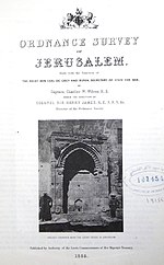 | The Ordnance Survey of Jerusalem of 1864–65 was the first scientific mapping of Jerusalem, and the first Ordnance Survey to take place outside the United... 12 KB (1,579 words) - 17:18, 17 February 2023 |
 | Tim; Pilbeam, Elaine (1992). Ordnance Survey. Southampton, England: Ordnance Survey. p. 64. ISBN 0-319-00498-8. Ordnance Survey (1957). 172 Chatham & Maidstone... 14 KB (1,580 words) - 20:04, 18 April 2023 |
 | Principal Triangulation of Great Britain (redirect from Trigonometrical Survey) triangulation survey of the whole of Great Britain and Ireland, carried out between 1791 and 1853 under the auspices of the Board of Ordnance. The aim of... 18 KB (2,183 words) - 09:27, 16 February 2024 |
mapping and surveying Ordnance Survey, a national mapping agency for Great Britain U.S. National Geodetic Survey, performing geographic surveys as part of... 3 KB (463 words) - 13:33, 1 November 2023 |
The Board of Ordnance was a British government body. Established in the Tudor period, it had its headquarters in the Tower of London. Its primary responsibilities... 66 KB (8,276 words) - 09:15, 13 April 2024 |
The Ordnance Survey International or Ordnance Survey Overseas Directorate its predecessors built an archive of air photography, map and survey records... 11 KB (973 words) - 09:31, 5 April 2023 |
 | Retriangulation of Great Britain (category Surveying of the United Kingdom) datum and Ordnance Survey National Grid in use today. The retriangulation was begun in 1935 by the Director General of the Ordnance Survey, Major-General... 25 KB (3,015 words) - 09:19, 16 March 2024 |
 | County Roscommon (section Ordnance Survey) visited County Roscommon in 1837, while compiling information for the Ordnance Survey. Entering St Peter's parish in Athlone in June 1837, he wrote, "I have... 23 KB (2,140 words) - 14:28, 2 April 2024 |
 | comprised several administrative counties and county boroughs. The Ordnance Survey adopted the term 'geographical county' to describe the widest definition... 47 KB (2,603 words) - 17:38, 1 April 2024 |
| century, but were instead known by local knowledge and custom. When the Ordnance Survey started producing large scale maps, they had to undertake extensive... 56 KB (6,078 words) - 13:44, 24 April 2024 |
 | National mapping agency (redirect from National survey) creation of the Ordnance Survey itself; work was begun in earnest in 1790, when the Board of Ordnance began a national military survey at one-inch-to-the-mile... 38 KB (4,041 words) - 07:01, 6 April 2024 |
| Topographic map (redirect from Topographical survey) defensive emplacements (thus the name and history of the United Kingdom's Ordnance Survey). As such, elevation information was of vital importance. As they evolved... 20 KB (2,043 words) - 19:20, 2 May 2024 |
 | Valuation Office (VO) and Ordnance Survey Ireland (OSI). In January 2018, the departmental responsibility relating to the Ordnance Survey Ireland, the Property... 4 KB (376 words) - 14:57, 1 February 2024 |
 | remeasured to be 1344.527m by Ordnance Survey. The height of Ben Nevis will therefore be shown on new Ordnance Survey maps as 1,345 metres (4,411 ft)... 55 KB (5,704 words) - 14:41, 22 March 2024 |
William Roy (section Histories of the Ordnance Survey) to the creation of the Ordnance Survey in 1791, the year after his death. His technical work in the establishment of a surveying baseline won him the Copley... 39 KB (4,682 words) - 16:43, 11 December 2023 |
 | Scafell Pike (section Survey point) have a name of its own; it was labelled Sca-Fell Higher Top by the Ordnance Survey in their initial work in Cumbria in the first decade of the 19th century... 23 KB (2,560 words) - 20:09, 7 February 2024 |
he spent most of his career as the archaeological officer of the Ordnance Survey (OS) and also wrote a range of books on archaeological subjects. Born... 67 KB (8,670 words) - 00:23, 27 April 2024 |
from Norman manors, plantation divisions, or later creations of the Ordnance Survey. The total number of inhabited townlands in Ireland was 60,679 in 1911... 29 KB (3,153 words) - 11:34, 30 April 2024 |
 | produced by the Ordnance Survey in 1931. The Ordnance Survey produced a revised folio in 1954–1957, and then carried out a complete re-survey in 1979–80.... 31 KB (3,245 words) - 16:14, 22 April 2024 |
widely used on Ordnance Survey benchmarks. Broad arrow marks were also used by Commonwealth countries on their ordnance. The Board of Ordnance was absorbed... 27 KB (3,246 words) - 12:37, 11 April 2024 |
GetOutside. Ordnance Survey. Retrieved 4 December 2023. "Blakeley Green, City of Wolverhampton - area information, map". OS GetOutside. Ordnance Survey. Retrieved... 8 KB (464 words) - 02:00, 6 December 2023 |
OpenStreetMap (section Surveys and personal knowledge) editor. OpenStreetMap was created by Steve Coast in response to the Ordnance Survey, the United Kingdom's national mapping agency, failing to release its... 67 KB (5,940 words) - 13:53, 30 April 2024 |
 | The former offices of Ordnance Survey are situated in London Road, Southampton, close to the junction with The Avenue, and are now part of the city's... 12 KB (1,408 words) - 14:34, 3 January 2024 |