
An orthophoto, orthophotograph, orthoimage or orthoimagery is an aerial photograph or satellite imagery geometrically corrected ("orthorectified") such...
6 KB (605 words) - 14:17, 7 December 2023
(global or local) and by the representation of this area (classic drawn or orthophoto). These maps cover the world, but may have insufficient details in some...
9 KB (921 words) - 02:59, 17 September 2024

A digital orthophoto quadrangle (DOQ) is aerial photography or satellite imagery that has been corrected so that its pixels are aligned with longitude...
3 KB (293 words) - 21:15, 13 August 2023
drawing time, or resampled to generate a georeferenced raster GIS file or orthophoto. The term georeferencing has also been used to refer to other types of...
13 KB (1,902 words) - 11:59, 6 September 2024

Schönbrunn—a far better aerial view, zoomable up to <1m resolution. *Click "Orthophoto" and "Draw new map", then zoom in [there seems to be no direct link]....
19 KB (1,873 words) - 19:27, 8 September 2024
OpenStreetMap offers the use of similar orthophotos for deriving new map data. Google Earth overlays orthophotos or satellite imagery onto a digital elevation...
43 KB (4,827 words) - 01:03, 19 August 2024
Surveying and Mapping Authority of the Republic of Slovenia, such as orthophoto covering entire territory of Slovenia with detailed imagery taken from...
3 KB (349 words) - 02:00, 20 September 2016

Geopedia.si Archived 2016-03-04 at the Wayback Machine (map, relief, orthophoto) Conditions in the Gulf of Trieste on and near the Slovene coast: Koper...
5 KB (416 words) - 15:22, 24 June 2024
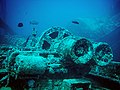
Royal Photographic Society's Science Photographer of the Year for his orthophoto (aerial photograph adjusted to have uniform scale) of the submerged wreck...
16 KB (1,557 words) - 17:41, 20 June 2024

system for facilitating the precise annotation of benthic species in orthophoto of the bottom of the sea. TagLab can automatically extract statistical...
5 KB (429 words) - 15:35, 4 January 2024
document similar to a map, but based on an orthophoto. Often, some annotations are added to the orthophoto. Similar to normal maps, can display a north...
2 KB (195 words) - 04:01, 31 July 2024
DOQ may refer: Digital orthophoto quadrangle - type of aerial photography or satellite imagery Denominación de Origen - regulatory classification system...
419 bytes (85 words) - 07:42, 18 January 2024

Schenectady County Airport USGS orthophoto IATA: SCH ICAO: KSCH FAA LID: SCH Summary Airport type Public Owner Schenectady County Serves Schenectady, New...
5 KB (466 words) - 12:40, 11 August 2024

Buffalo Niagara International Airport USGS orthophoto IATA: BUF ICAO: KBUF FAA LID: BUF Summary Airport type Public Owner/Operator Niagara Frontier Transportation...
51 KB (3,922 words) - 18:28, 23 August 2024
Scales, Fact Sheet FS105-02, (February 2002) "Quarter Quad of Digital Orthophoto Quadrangle (DOQs) Color". Retrieved 2023-01-01. "USGS 3.75 minute quarter...
4 KB (361 words) - 01:11, 20 August 2023
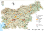
Wikimedia Commons has media related to Geography of Slovenia. – Geodesic Institute of Slovenia – Detailed Topographic and Orthophoto maps of Slovenia...
19 KB (1,574 words) - 23:23, 19 August 2024

Monkey Island USGS 1995 orthophoto Monkey Island Location on a map of Oklahoma Coordinates: 36°35′N 94°52′W / 36.59°N 94.87°W / 36.59; -94.87 Country...
3 KB (126 words) - 13:01, 7 April 2020
CATUAV (section Orthophotos)
allows the creation of orthophoto mosaics and digital elevation model (DEM). Some services the company offers include: Orthophotos are aerial photographies...
15 KB (1,739 words) - 16:06, 8 January 2024

Aerial orthophoto, 2011. Note scale at lower right....
7 KB (593 words) - 03:13, 24 April 2024

Lakefront Airport (former New Orleans Army Air Base) USGS 2006 orthophoto Lakefront Airport, main terminal, 2010 IATA: NEW ICAO: KNEW FAA LID: NEW Summary...
13 KB (1,262 words) - 23:19, 31 March 2024

an emergency response, such as Geographic Information Systems (GIS), orthophoto mapping, National Fire Danger Rating System, remote automatic weather...
6 KB (698 words) - 01:38, 2 June 2024

Destin–Fort Walton Beach Airport Eglin Air Force Base USGS 1999 orthophoto IATA: VPS ICAO: KVPS FAA LID: VPS Summary Airport type Public / Military joint-use...
26 KB (2,251 words) - 23:04, 17 September 2024

Louis Armstrong New Orleans International Airport Moisant Field 2006 USGS orthophoto, prior to the construction of the current terminal IATA: MSY ICAO: KMSY...
40 KB (2,725 words) - 18:24, 20 September 2024

Grant County International Airport USGS 1996 orthophoto IATA: MWH ICAO: KMWH FAA LID: MWH Summary Airport type Public Owner Port of Moses Lake Serves Grant...
16 KB (1,458 words) - 02:38, 11 June 2024

com. 19 September 2019. The chicane is absent in Lantmäteriet Historic Orthophoto 1975 (from lantmateriet.se), but is reported in the contemporary race...
32 KB (1,567 words) - 02:54, 25 July 2024
the viewer. Maps use, for example, an orthogonal projection (so-called orthophoto), but oblique images of a landscape cannot be used in this way - although...
28 KB (4,379 words) - 17:04, 2 August 2024

Smith International Airport (former South Plains Army Airfield) 2006 orthophoto IATA: LBB ICAO: KLBB FAA LID: LBB Summary Airport type Public Owner City...
21 KB (1,704 words) - 15:04, 26 April 2024
Laurence G. Hanscom Field USGS 2006 orthophoto IATA: BED ICAO: KBED FAA LID: BED Summary Airport type Public / military Operator Massachusetts Port Authority...
13 KB (1,310 words) - 20:03, 15 September 2024

Presque Isle International Airport USGS 2006 orthophoto IATA: PQI ICAO: KPQI FAA LID: PQI Summary Airport type Public Owner City of Presque Isle Serves...
19 KB (1,760 words) - 06:50, 5 September 2024
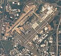
Piedmont Triad International Airport USGS 2006 orthophoto IATA: GSO ICAO: KGSO FAA LID: GSO Summary Airport type Public Owner/Operator Piedmont Triad Airport...
36 KB (2,776 words) - 05:39, 12 September 2024