 | Parkway–South Sacramento is a former census-designated place (CDP) in Sacramento County, California, United States. It is part of the Sacramento–Arden-Arcade–Roseville... 11 KB (781 words) - 21:43, 27 July 2023 |
 | Area codes 916 and 279 (redirect from Sacramento area codes) Park North Highlands Orangevale Parkway-South Sacramento Rancho Cordova Rancho Murieta Rio Linda Rosemont Sacramento Vineyard Walnut Grove Wilton Pleasant... 6 KB (476 words) - 23:54, 1 September 2023 |
Parkway is a Census-designated place in Sacramento County, California. Parkway sits at an elevation of 20 feet (6.1 m). The 2010 United States census reported... 6 KB (503 words) - 21:48, 12 July 2023 |
 | Lemon Hill, California (category Census-designated places in Sacramento County, California) States census, Lemon Hill was grouped with Parkway and Fruitridge Pocket in the Parkway-South Sacramento, California CDP. According to the United States... 6 KB (511 words) - 05:28, 12 July 2023 |
Center Parkway station is a side platformed Sacramento RT light rail station in Sacramento, California, United States. The station was opened on August... 2 KB (134 words) - 09:50, 30 April 2023 |
 | Land Park, Little Pocket, Mangan Park, Meadowview, Parkway, Pocket, Sacramento City College, South Land Park, Valley Hi / North Laguna, Z'Berg Park. Area... 151 KB (14,403 words) - 01:32, 10 May 2024 |
 | Fruitridge Pocket, California (category Census-designated places in Sacramento County, California) States census, Fruitridge Pocket was grouped with Parkway and Lemon Hill in the Parkway-South Sacramento, California CDP. According to the United States... 7 KB (532 words) - 05:31, 10 July 2023 |
 | The Arroyo Seco Parkway, also known as the Pasadena Freeway, is one of the oldest freeways built in the United States. The parkway connects Los Angeles... 46 KB (5,022 words) - 18:02, 13 April 2024 |
Florin Towne Centre (category Shopping malls in Sacramento County, California) in the unincorporated area of Parkway-South Sacramento in Sacramento County, California, United States, in the Sacramento area. It opened in 2008 on the... 11 KB (1,257 words) - 22:51, 28 March 2024 |
Highway 99 near the Sacramento International Airport to Highway 65 just south of Lincoln and north of Rocklin at the Whitney Ranch Parkway interchange. The... 2 KB (196 words) - 00:18, 29 September 2023 |
Valley Parkway interchange, 2022 E3: US 50/Silva Valley Parkway Interchange, 2016 Placer Parkway "Project Overview - Sacramento Capital SouthEast Connector... 8 KB (808 words) - 20:13, 13 November 2023 |
 | The Greater Sacramento area refers to a metropolitan region in Northern California comprising either the U.S. Census Bureau defined Sacramento–Roseville–Folsom... 38 KB (2,652 words) - 10:16, 15 May 2024 |
List of shopping malls in the United States (redirect from List of shopping malls in South Carolina) outdoor) FIGat7th – Los Angeles (1986–present) Florin Mall – Parkway–South Sacramento (1968–2006) Galleria at Tyler – Riverside (1970–present) Glendale... 131 KB (8,776 words) - 17:52, 6 May 2024 |
Inyo County 92328 Parkway 1 Sacramento County 95823 Parkway Estates 1 Sacramento County 95826 Parkway-South Sacramento 1 Sacramento County Parkwood 1... 38 KB (77 words) - 02:09, 6 January 2024 |
 | American River (category Tributaries of the Sacramento River) River Parkway Foundation (ARPF): environmental protection, native habitat preservation, Sacramento, CA (916) 486-2773". American River Parkway Foundation... 40 KB (4,170 words) - 00:58, 6 February 2024 |
 | California State Route 58 (redirect from Westside Parkway) 2019). "Officially Designated State Scenic Highways and Historic Parkways" (XLSX). Sacramento: California Department of Transportation. Retrieved October 14... 29 KB (2,139 words) - 05:53, 26 February 2024 |
California. The SCUSD serves most of Sacramento south of the American River, portions of La Riviera, Mather, Parkway and Rancho Cordova and all of Fruitridge... 12 KB (1,193 words) - 05:00, 17 February 2024 |
east-west arterial in Sacramento County, California, United States. It is approximately 8 miles (13 km) long and runs through Sacramento and the unincorporated... 9 KB (710 words) - 19:54, 23 March 2024 |
 | seat is Sacramento, which has been the state capital of California since 1854. Sacramento County is the central county of the Greater Sacramento metropolitan... 74 KB (2,768 words) - 15:20, 23 April 2024 |
 | California State Route 241 (redirect from Los Patrones Parkway) Patrones Parkway that extends the right-of-way south to Rancho Mission Viejo, but local officials do not intend to hand over control of the parkway to the... 25 KB (2,455 words) - 15:11, 25 January 2024 |
Dry Creek (Steelhead Creek tributary) (redirect from Dry Creek (Sacramento River)) Steelhead Creek flows south into Discovery Park in American River Parkway and then west (parallel with American River) into Sacramento River. Dry Creek tributaries... 5 KB (474 words) - 12:01, 4 April 2024 |
 | University, Sacramento (CSUS, Sacramento State, or informally Sac State) is a public university in Sacramento, California. Founded in 1947 as Sacramento State... 84 KB (8,117 words) - 00:54, 28 March 2024 |
 | 1974–1976 Location: Sutterville Road (south, right field); Panther Parkway and Sacramento City College (west, first base); college parking lot (north, third... 3 KB (393 words) - 14:08, 16 August 2023 |
 | Capitol Mall (category Transportation in Sacramento, California) landscaped parkway in the state capital city of Sacramento, California. Formerly known as M Street, it connects the city of West Sacramento in Yolo County... 20 KB (1,841 words) - 20:18, 23 March 2024 |
Street on the South, J Street on the North, 16th Street on the West and 30th Street on the East. However, the streets in Sacramento's original "grid"... 9 KB (988 words) - 22:14, 28 March 2024 |
 | Interstate 780 (redirect from Curtola Parkway) the San Francisco Bay Area of Northern California. It runs from Curtola Parkway and Lemon Street in Vallejo to I-680 just north of the Benicia–Martinez... 14 KB (1,593 words) - 06:44, 22 August 2023 |
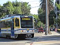 | is a light rail line in the Sacramento Regional Transit District (RT) system. It runs primarily north–south in Sacramento between Watt/I-80 and Cosumnes... 16 KB (1,110 words) - 08:21, 22 April 2024 |
 | Interstate 110 and State Route 110 (California) (redirect from Harbor Parkway) the Arroyo Seco Parkway and Riverside Parkway south of Dodger Stadium. The West By-Pass was soon incorporated into the Harbor Parkway, and the first short... 37 KB (3,050 words) - 07:14, 17 March 2024 |
 | French Valley Parkway and Winchester Road. California Roads portal California Department of Transportation. "State Truck Route List". Sacramento: California... 26 KB (2,123 words) - 09:18, 8 May 2024 |
 | Fair Oaks, California (category Census-designated places in Sacramento County, California) is a census-designated place (CDP) in Sacramento County, California, United States. It is part of the Sacramento–Arden-Arcade–Roseville Metropolitan Statistical... 28 KB (3,268 words) - 04:45, 12 February 2024 |