 | Pedro Reinel (fl. 1485 – 1540) was a Portuguese cartographer. Between 1485 and 1519 Reinel served three Portuguese kings: João II, Manuel I and João III... 6 KB (715 words) - 04:51, 23 April 2024 |
cartographer Pedro Reinel Pedro Reinel (c. 1462–c. 1542), Portuguese cartographer, author of one of the oldest signed Portuguese nautical charts "Reinel". Forebears... 580 bytes (103 words) - 16:22, 28 August 2017 |
 | An older (medieval) convention is the manicule (pointing hand, 👈). Pedro Reinel in c. 1504 first used the fleur-de-lis as indicating north in a compass... 35 KB (627 words) - 12:25, 30 April 2024 |
Jorge Reinel (c. 1502 – after 1572) born in Lisbon was a Portuguese cartographer and instructor in cartography, son of the well-known cartographer Pedro Reinel... 4 KB (412 words) - 04:51, 23 April 2024 |
Pont (Scotland, 1565–1614) Pedro Reinel (Portugal ?–c. 1542), author of the oldest signed Portuguese nautical chart Jorge Reinel (Portugal c. 1502–c. 1572)... 30 KB (3,124 words) - 01:58, 13 April 2024 |
cartographer Pedro Reinel made the oldest known nautical chart with a scale of latitudes. 1519 : Portuguese cartographers Lopo Homem, Pedro Reinel and Jorge... 142 KB (17,588 words) - 11:31, 14 April 2024 |
 | north mark. The use of the fleur-de-lis as north mark was introduced by Pedro Reinel, and quickly became customary in compass roses (and is still often used... 27 KB (2,851 words) - 19:36, 1 April 2024 |
 | Miller Atlas (redirect from Lopo Homem-Reinel Atlas) charts. It is a joint work of the cartographers Lopo Homem, Pedro Reinel and Jorge Reinel, and illustrated by miniaturist António de Holanda. The regions... 5 KB (586 words) - 01:39, 11 April 2024 |
 | and naval technology, including Pedro Nunes, João de Castro, Abraham Zacuto, and Martin Behaim. Cartographers Pedro Reinel, Lopo Homem, Estêvão Gomes, and... 115 KB (13,609 words) - 23:59, 30 April 2024 |
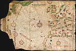
 | Portolan made by Pedro Reinel in 1485 representing the Western Europe and parts of Africa, reflecting the explorations made by Diogo Cão. Reinel was also author... 134 KB (16,497 words) - 15:19, 27 April 2024 |
 | earliest record of the location appears as São João on a Portuguese map by Pedro Reinel in 1519. When the English mariner John Rut visited St. John's in 1527... 153 KB (12,182 words) - 06:03, 23 April 2024 |
 | 1501, and shortly after that date Funk Island appears on two maps by Pedro Reinel as Y Dos Saues (1504) and Ylhas das aves (1520), both of which refer... 14 KB (1,917 words) - 14:08, 1 May 2024 |
 | (1459) and the maps of Henricus Martellus Germanus (1484, 1489) and Pedro Reinel (c. 1485). With a few exceptions (e.g. Ruysch), Antillia disappears from... 40 KB (5,236 words) - 14:13, 27 March 2024 |
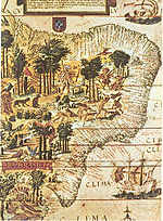
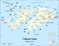 | Gonneville (France) sights islands that may have been the Falklands. 1522: Pedro Reinel (Portugal) Unrecorded Portuguese expedition may have sighted the Falkland... 50 KB (5,450 words) - 15:00, 22 April 2024 |
 | Miller Atlas, dated 1519, which is thought to be a joint work with Pedro Reinel, Reinel's son Jorge, and António de Holanda. There is, however, some disagreement... 18 KB (1,927 words) - 04:51, 23 April 2024 |
literature – Bergadis' Apokopos; Miller Atlas by Lopo Homem, Pedro Reinel and Jorge Reinel; The Abbreviacion of Statutis by John Rastell 1520 in literature... 149 KB (15,876 words) - 13:47, 1 May 2024 |
 | Portolan made by Pedro Reinel in 1485 representing the Western Europe and parts of Africa, reflecting the explorations made by Diogo Cão. Reinel was also author... 45 KB (5,797 words) - 18:25, 31 March 2024 |
Portolan made by Pedro Reinel in 1485 representing Western Europe and parts of Africa, reflecting the explorations made by Diogo Cão. Reinel was also author... 8 KB (1,053 words) - 01:11, 15 May 2023 |
 | Portuguese Empire, by Lazaro Luis The 1504 map of North Africa and Europe, by Pedro Reinel The 1583 map of global European empires, by Sebastião Lopes In Portugal... 33 KB (3,899 words) - 16:10, 12 March 2024 |
earliest record of the location appears as São João on a Portuguese map by Pedro Reinel. 1527 – When John Rut visited St. John's in 1526 he found Norman, Breton... 9 KB (1,183 words) - 19:32, 22 March 2024 |
(1991) João das Regras, jurist (1927; 1949) José Régio, writer (2001) Pedro Reinel, cartographer (1985) José Relvas, politician (2008) Aquilino Ribeiro... 19 KB (2,071 words) - 21:14, 13 October 2023 |
the first literary work created in the New World. Lopo Homem, Pedro Reinel and Jorge Reinel (illustrated by António de Holanda) – "Miller Atlas" William... 5 KB (502 words) - 10:19, 30 July 2021 |
 | Duarte Barbosa, Estêvão Gomes, João Serrão, Ferdinand Magellan and Jorge Reinel, cosmographers Francisco and Ruy Faleiro and the Flemish merchant Christopher... 8 KB (769 words) - 04:51, 23 April 2024 |
 | not survive. The oldest signed Portuguese nautical chart, created by Pedro Reinel, dates back to 1485. Within the first fleets that were sent into the... 27 KB (3,745 words) - 16:47, 17 March 2023 |
timepiece, the first "Nuremberg Eg". Pedro Nunes, Portuguese mathematician (died 1578) approx. date – Jorge Reinel, Portuguese cartographer (d. after 1572)... 2 KB (188 words) - 17:45, 1 January 2023 |
 | of Mandinka origin He was seized by the Portuguese slave trader, Pedro Gomes Reinel, sold to businessman Juan Palacios, and later, after transportation... 7 KB (719 words) - 08:48, 17 December 2023 |
 | Seen as claimed in the Cantino planisphere of 1502, Reinel-Lopo Homem chart of 1519 and Reinel map of 1535. Land of the Corte-Real: (1501–?) claimed... 25 KB (3,003 words) - 00:14, 4 May 2024 |
a number of events, some of which are listed below. probable date – Pedro Reinel's Atlantic chart is the earliest known nautical chart with a scale of... 1 KB (124 words) - 17:52, 1 January 2023 |
 | Prime Minister Pedro Pablo Kuczynski Minister Óscar Maúrtua Preceded by Javier Gonzales Terrones Succeeded by Gonzalo Gutiérrez Reinel Member of Congress... 7 KB (396 words) - 12:24, 22 April 2024 |
later Turkish Armed Forces. Francisco Nunez Olivera (1904–2018) – Spain. Reinel Cianca Gutiérrez (1901–2002) – Panama. Altino Gomes da Silva (1904–1996) –... 119 KB (10,622 words) - 13:58, 3 May 2024 |