 | Pictorial maps (also known as illustrated maps, panoramic maps, perspective maps, bird's-eye view maps, and geopictorial maps) depict a given territory... 13 KB (1,601 words) - 19:00, 13 January 2024 |
 | Hypsometric tints Map design Orthophotomap—A map created from orthophotography Pictorial maps Plat Road atlas Strip map Transit map Page layout (cartography)... 33 KB (4,185 words) - 21:14, 15 April 2024 |
 | Cartography (redirect from Map making) Collaborative project to create a free editable map of the world Pictorial map – Map that uses pictures to represent features Planetary cartography –... 61 KB (7,307 words) - 04:01, 23 March 2024 |
 | Hall 1000 Commonwealth Ave Newton, MA City Government-Executive Offices - MapQuest". www.mapquest.com. Retrieved March 29, 2017. Wikimedia Commons has... 7 KB (534 words) - 21:24, 15 April 2024 |
 | writing, and even the Roman alphabet, owe their origins in some respects to pictorial representations. Images of any type may convey different meanings and... 24 KB (2,920 words) - 10:59, 30 April 2024 |
 | Fantasy cartography (redirect from Fictional map) Fantasy cartography, fictional map-making, or geofiction is a type of map design that visually presents an imaginary world or concept, or represents a... 30 KB (2,835 words) - 16:14, 11 November 2023 |
 | Pictorial map of Crusoe's island, the "Island of Despair", showing incidents from the book... 53 KB (6,277 words) - 15:38, 16 April 2024 |
 | the heart of USC's historic campus as it looks today. Show map of South Carolina Show map of the United States Location Bounded by Pendleton, Sumter,... 4 KB (330 words) - 01:45, 8 August 2023 |
 | 2005 United Nations Environment Programme map: Landcover of the Caucasus United Nations Environment Programme map: Population density of the Caucasus Food... 55 KB (5,656 words) - 00:12, 28 April 2024 |
 | identified in a pictorial map of 1682 by William Morgan. Reproduced in Barker, Felix; Jackson, Peter (1990). The History of London in Maps. London: Barrie... 24 KB (2,467 words) - 14:10, 13 March 2024 |
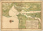 | The Manatus Map is a 1639 pictorial map of the New York–New Jersey Harbor Estuary at the time the area was part of the colony of New Netherland. Entitled... 8 KB (950 words) - 12:21, 16 February 2024 |
 | NBC News, AP, 2009-04-12, archived from the original on 2013-10-21 "Pictorial Map and Visitor's Guide to Forest Lawn Memorial-Park, Glendale, California"... 13 KB (1,314 words) - 17:20, 21 March 2024 |
 | draughtsman active from ca. 1871 to 1904 in the United States. Drie created pictorial maps of various cities including a 110-sheet view of St. Louis, Missouri... 2 KB (183 words) - 22:14, 20 March 2024 |
 | use of diagrams that visually "map" information using branching and radial maps traces back centuries. These pictorial methods record knowledge and model... 15 KB (1,675 words) - 07:12, 22 March 2024 |
 | Archimedean point Camera angle Cinematic techniques Filmmaking Google Earth Pictorial map Pictometry Plans (drawings) Top-down perspective Video production Worm's-eye... 7 KB (751 words) - 02:24, 21 March 2024 |
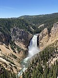 | Yellowstone Lake (Map). National Geographic Maps. 2003. ISBN 9781566953610. National Geographic Tower/Canyon (Map). National Geographic Maps. 2008. ISBN 9781566954358... 163 KB (15,753 words) - 15:24, 25 April 2024 |
Animated mapping (redirect from Animated map) of cartographers Map projection – Systematic representation of the surface of a sphere or ellipsoid onto a plane Pictorial map – Map that uses pictures... 11 KB (1,370 words) - 18:05, 27 November 2023 |
 | and Conservation. Retrieved June 23, 2020. "Tennessee Valley Area: pictorial map". U.S. Government Printing Office. 1939. Retrieved June 23, 2020 – via... 19 KB (1,281 words) - 03:38, 20 April 2024 |
Cartographic propaganda (redirect from Persuasive map) created the "Pictorial Map of European Russia" (which was published in Warsaw in 1896 and 1903) that provoked an image of Utopia in Russia. The map was intended... 33 KB (3,907 words) - 06:12, 5 March 2024 |
 | Fox-Davies, A.C., 1915, The Book of Public Arms, London "17th Century Pictorial Map of Galway City". Archived from the original on 1 November 2018. Retrieved... 32 KB (3,504 words) - 23:03, 25 April 2024 |
 | identified by pictorial glyphs representing turreted castles or walled towns, distinguished in order of their importance. The making of the map was a major... 25 KB (3,404 words) - 18:31, 27 April 2024 |
 | publication The War Pictorial, which by December 1916 had reached a circulation of 500,000, covering 11 languages. The War Pictorial was deemed to have... 46 KB (5,569 words) - 06:35, 12 February 2024 |
 | (paperback ed.). McGill-Queen's University Press. pp. 33–51. ISBN 0-7735-2081-3. Shazam! Vol. 3 #7-10. DC Comics. Pictorial map of "Alice's Wonderland"... 8 KB (680 words) - 15:57, 18 December 2023 |
 | 1931 pictorial map by Jo Mora... 33 KB (3,923 words) - 23:11, 9 November 2023 |
 | ISSN 2447-7125. "菱川師宣の浮世絵「見返り美人図」を解説!見どころはどこ? | thisismedia". 6 April 2021. "Pictorial Map of the Tōkaidō Highroad". World Digital Library. Retrieved 6 May 2013... 12 KB (1,422 words) - 22:01, 10 April 2024 |
 | depictions of physical landscape, as is generally associated with maps in modern times, but pictorial images, often including spiritual landscape in addition to... 25 KB (3,624 words) - 05:45, 16 February 2024 |
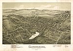
 | Pictorial map, 1875... 43 KB (4,011 words) - 20:41, 29 April 2024 |
 | system, Donora has a humid subtropical climate, abbreviated "Cfa" on climate maps. Donora is only bordered by land with Carroll Township to the north, south... 24 KB (1,941 words) - 15:30, 30 April 2024 |
 | Cartoonist Fashion illustration Graphic designer Marker rendering Painters Pictorial maps Storyboard artist Stuttgart Database of Scientific Illustrators Visualizer... 6 KB (598 words) - 08:04, 2 April 2024 |
 | object or referent). Map symbols can thus be categorized by how they suggest this connection: Iconic symbols (also "image", "pictorial", or "replicative")... 19 KB (2,107 words) - 08:59, 22 December 2023 |