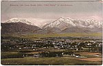
Pomona Valley is located in the Greater Los Angeles Area between the San Gabriel Valley and San Bernardino Valley in Southern California. The valley is...
13 KB (1,149 words) - 00:35, 31 January 2024

Pomona (/pəˈmoʊnə/ pə-MOH-nə) is a city in eastern Los Angeles County, California, United States. Pomona is located in the Pomona Valley, between the Inland...
59 KB (4,493 words) - 17:21, 28 August 2024

east, with the Pomona Valley and Inland Empire beyond; and the city limits of Los Angeles, bordering its western edge. The San Gabriel Valley derives its...
61 KB (6,701 words) - 21:30, 20 August 2024
the eastern Pomona Valley and western San Bernardino Valley. It is located between Los Angeles and San Bernardino. The Cucamonga Valley AVA, a designated...
4 KB (372 words) - 23:06, 14 May 2024
The Inland Valley Daily Bulletin is a daily newspaper based in Ontario, California, serving the Pomona Valley and southwest San Bernardino County. The...
5 KB (282 words) - 01:01, 31 August 2024
Pomona College (/pəˈmoʊnə/ pə-MOH-nə) is a private liberal arts college in Claremont, California. It was established in 1887 by a group of Congregationalists...
255 KB (16,708 words) - 20:23, 2 September 2024

California State Route 60 (redirect from Pomona Freeway)
Pomona Valley and San Gabriel Valley. The highway also runs concurrently with SR 57 and I-215. Portions of SR 60 are designated as either the Pomona Freeway...
34 KB (2,612 words) - 05:50, 19 September 2024

California State Route 71 (redirect from Pomona Rincon Road)
SR 371. The early section of the Chino Valley Freeway was built in 1971 from the Kellogg Interchange to SR 60 (the Pomona Freeway). The section from SR 60 to...
15 KB (1,340 words) - 03:53, 16 September 2024
California State Polytechnic University Pomona (Cal Poly Pomona), is a public polytechnic university in Pomona, California. It is the largest (by student...
102 KB (9,345 words) - 18:18, 18 September 2024
Claremont, California (category Pomona Valley)
east of Los Angeles. It lies in the eastern portion of the county, in Pomona Valley, at the foothills of the San Gabriel Mountains. As of the 2010 census...
45 KB (3,727 words) - 05:35, 18 September 2024

San Dimas, California (category Pomona Valley)
San Gabriel Valley Railroad." by Hoyt, Franklyn., Pacific Historical Review 20 (August 1951): 227–239 "Full text of "History of Pomona Valley, California...
33 KB (3,366 words) - 12:33, 11 August 2024

Pomona Valley. Elevation varies from 590 feet (180 m) on valley floors near Chino to 1,380 feet (420 m) near San Bernardino and Redlands. The valley floor...
24 KB (2,240 words) - 06:37, 13 February 2024

California State Route 57 (category Pomona Valley)
Peninsular Ranges, linking the Los Angeles Basin with the Pomona Valley and San Gabriel Valley. A predecessor to this road ran through Brea Canyon by the...
28 KB (3,114 words) - 00:43, 15 September 2024
The Chino Valley is a sub−valley section of the large Pomona Valley, located in southwestern San Bernardino County, California. The cities of Chino Hills...
1 KB (154 words) - 03:48, 1 May 2024

Montclair, California (category Pomona Valley)
Montclair is a city in the Pomona Valley, in southwestern San Bernardino County, California, 35 miles (56 km) east of downtown Los Angeles. The population...
17 KB (1,417 words) - 19:01, 8 September 2024

Chino Hills, California (category Pomona Valley)
border of Chino Hills roughly follows the Chino Valley Freeway (SR 71), which offers access to the Pomona Freeway (SR 60) to the north and the Riverside...
35 KB (3,247 words) - 00:46, 2 September 2024

Chino.” Pomona Valley Historian 13 (Winter 1979): 33-6. Black, Esther Boulton. “Ranch life in San Antonio Canyon in the 1870s.” Pomona Valley Historian...
16 KB (1,885 words) - 00:23, 12 June 2024

Chino, California (category Pomona Valley)
County to the southwest. It is easily accessible via the Chino Valley (71) and Pomona (60) freeways. The population was 91,403 at the 2020 census. The...
35 KB (2,805 words) - 22:16, 26 August 2024
Gabriel Valley Pomona Valley Puente Hills Crescenta Valley Peninsular Ranges (North) San Jacinto Mountains Santa Rosa Mountains Santa Clarita Valley San Gabriel...
6 KB (377 words) - 04:44, 5 May 2024
La Verne, California (category Pomona Valley)
Verne is a suburb 30 miles (48 km) east of Los Angeles, located in the Pomona Valley below the foothills of the San Gabriel Mountains part of the Angeles...
22 KB (1,949 words) - 12:20, 29 August 2024
Area codes 909 and 840 (category Pomona Valley)
(mostly in the 626 area code and small portion in the 562 area code) La Verne Pomona Rowland Heights (also in the 626 area code and small portion in the 562...
8 KB (915 words) - 11:52, 8 September 2024

San Antonio Heights, California (category Pomona Valley)
(CDP) in the San Bernardino County, California. It is in the northern Pomona Valley and the foothills of the San Gabriel Mountains. The population was 3...
14 KB (1,427 words) - 07:03, 9 September 2024

San Bernardino Line (category Pomona Valley)
passing sidings and short sections of double track near Covina, between Pomona and Montclair, west of Fontana, and throughout San Bernardino. Los Angeles...
22 KB (1,543 words) - 07:36, 19 September 2024

Rancho Cucamonga, California (category Pomona Valley)
providing connection (in addition to I-10 and SR-60) from the San Gabriel Valley and points west to the San Bernardino area.[citation needed] Rancho Cucamonga...
60 KB (4,979 words) - 01:23, 20 September 2024

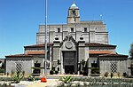
Spadra Cemetery (category Pomona, California)
acres (1.0 ha) cemetery in Pomona, California. Containing 212 graves, it is protected by the Historical Society of Pomona Valley (HSPV), which offers occasional...
5 KB (376 words) - 20:08, 7 July 2024

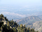
Inland Empire (redirect from Valley of the Dirt People)
splitting the San Gabriel Valley from the Pomona Valley, leading to the urban populations centered in the San Bernardino Valley. From the south to north...
113 KB (10,465 words) - 21:57, 10 September 2024

California's 35th congressional district (category Pomona Valley)
Dr, Alta Mira Pl, Rancho Laguna Dr, W Mission Blvd, W Temple Ave, Pomona Blvd, Valley Blvd, San Bernardino Freeway, Walnut City Parkland, San Bernardino...
55 KB (829 words) - 18:04, 14 July 2024
limits of Pomona, in Los Angeles County, California. It is located near the Pomona Freeway (SR 60), the Orange Freeway (SR 57), and the Chino Valley Freeway...
8 KB (1,094 words) - 06:18, 28 July 2024
primarily on experimental home recording and cassette culture in the Pomona Valley at that time. The band consists of Joel Huschle, Mark Givens, and Dave...
2 KB (226 words) - 11:38, 30 April 2023

17 elderly women dead. However, in the mid-1980s, the police in the Pomona Valley area became aware of a serial killer with the same modus operandi as...
17 KB (1,910 words) - 10:42, 12 September 2024