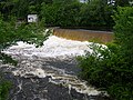
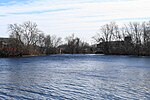
 | The Quinebaug River (/ˈkwɪnəbɔːɡ/ KWIH-nə-bawg) is a river in south-central Massachusetts and eastern Connecticut, with watershed extending into western... 12 KB (577 words) - 04:20, 5 April 2024 |
 | Island Sound. The Thames River watershed includes a number of smaller basins and the 80-mile (130 km) long Quinebaug River, which rises in southern Massachusetts... 6 KB (429 words) - 04:26, 5 April 2024 |
 | Willimantic and Natchaug rivers. It flows southeast and south. Approximately 4 miles (6 km) northeast of Norwich it receives the Quinebaug River and broadens into... 8 KB (452 words) - 20:11, 27 April 2023 |
 | Connecticut. The Five Mile is a tributary of the Quinebaug River and is part of the Thames River watershed. Its source is Little Pond (also known as... 4 KB (206 words) - 12:02, 18 January 2024 |
highlands are the source for several rivers, including the Quinebaug River, and are part of the Quinebaug and Shetucket Rivers Valley National Heritage Corridor... 4 KB (293 words) - 14:39, 25 April 2024 |
Pequotsepos River Poquonock River Thames River Oxoboxo River Shetucket River Quinebaug River Pachaug River Blackwell Brook Moosup River Five Mile River Little... 6 KB (414 words) - 20:57, 29 April 2024 |
 | was initially inhabited by the Nipmuck and Mohegan tribes, with the Quinebaug River dividing their territories. As early as 1638, John Winthrop Jr. purchased... 18 KB (1,901 words) - 11:15, 25 January 2024 |
 | Examples include the Kennebec River ("long water place") and Kennebunk in Maine, the Quinebaug River ("long pond"), Quinapoxet River ("at the little long pond")... 38 KB (3,889 words) - 18:18, 8 February 2024 |
River West River Mumford River Quinsigamond River Middle River Kettle Brook Thames River (Connecticut) Shetucket River (Connecticut) Quinebaug River French... 20 KB (1,631 words) - 02:15, 3 March 2024 |
 | Dam – Quinebaug River Allatoona Dam – Lake Allatoona Bartlett's Ferry Dam – Lake Harding Blue Ridge Dam – Blue Ridge Reservoir; on the Toccoa River; finished... 41 KB (3,533 words) - 02:38, 14 April 2024 |
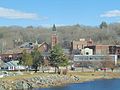
 | Putnam (CDP), Connecticut (redirect from Quinebaug Falls) it consists of the main town center of the town of Putnam along the Quinebaug River. The village is part of the Northeastern Connecticut Planning Region... 6 KB (442 words) - 01:18, 31 December 2023 |
 | established around a cotton mill powered by the Quinebaug River. Wauregan and West Wauregan, across the Quinebaug in the town of Brooklyn, together comprise... 18 KB (1,870 words) - 15:04, 31 January 2024 |
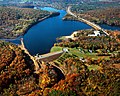 | The East Brimfield Dam is located on the Quinebaug River in Sturbridge, Massachusetts, approximately 20 miles (32 km) southwest of Worcester, Massachusetts... 6 KB (720 words) - 07:05, 30 November 2021 |
 | Quinebaug (/ˈkwɪnəbɔːɡ/ KWIH-nə-bawg) is a village and census-designated place (CDP) in Thompson, a town in Windham County, Connecticut, United States... 6 KB (433 words) - 04:19, 5 April 2024 |
 | and severs the town. The portion of the CDP near the Quinebaug River is known as the Quinebaug Mill-Quebec Square Historic District. According to the... 6 KB (488 words) - 17:15, 29 November 2023 |
 | are several moderately sized rivers, including the French River and Five Mile River, both tributaries of the Quinebaug River, which also runs through Thompson... 17 KB (1,554 words) - 21:19, 28 April 2024 |
 | non-profit organization The Trustees of Reservations, is named for the Quinebaug River, which runs through the reservation. The reservation is located off... 9 KB (1,140 words) - 23:56, 19 July 2021 |
Thames River (Connecticut) Quinebaug River (Connecticut) Five Mile River Leeson Brook Moosup River Quaduck Brook Pawcatuck River Ashaway River Green Fall... 5 KB (343 words) - 15:55, 14 December 2023 |
 | The Westville Dam is located on the Quinebaug River between Southbridge and Sturbridge, about 1.3 miles (2.1 km) west of the Southbridge town center and... 5 KB (575 words) - 17:39, 23 September 2023 |
 | Forest at the Connecticut - Rhode Island border and draining into the Quinebaug River. It is crossed by the Ashland Mill Bridge in Griswold, Connecticut... 6 KB (464 words) - 05:46, 25 February 2024 |
 | The Quinebaug River Prehistoric Archeological District encompasses a collection of prehistoric archaeological sites near the Quinebaug River in Canterbury... 3 KB (319 words) - 21:37, 8 August 2023 |
Massachusetts Quinault River - Washington Quinebaug River - Connecticut Quinn River - Nevada Quinnipiac River - Connecticut Quinsigamond River - Massachusetts... 2 KB (108 words) - 19:55, 14 March 2022 |
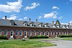 | Quinebaug Mill–Quebec Square Historic District is a historic district roughly bounded by the Quinebaug River, Quebec Square, and Elm and S. Main Streets... 5 KB (384 words) - 21:37, 8 August 2023 |
 | August 18–19. The result was flooding in many of the state's rivers, including the Quinebaug River. The resulting torrent of water destroyed homes, businesses... 16 KB (1,305 words) - 21:16, 28 April 2024 |
miles (224 km) Quinebaug River – 69 miles (111 km) Farmington River – 47 miles (76 km) Quinnipiac River – 46 miles (74 km) Scantic River – 41 miles (66 km)... 33 KB (4,253 words) - 05:25, 8 January 2024 |
 | Norwich, Connecticut (category Populated places on the Thames River (Connecticut)) States. The Yantic, Shetucket, and Quinebaug Rivers flow into the city and form its harbor, from which the Thames River flows south to Long Island Sound... 41 KB (3,930 words) - 05:23, 6 May 2024 |
 | Lyme, Connecticut in the United States, sitting high above the Connecticut River. The castle was designed and built by William Gillette (1853–1937), an American... 13 KB (1,311 words) - 22:54, 3 April 2024 |
 | The Quinebaug Trail is a 8.1-mile (13.0 km) Connecticut hiking trail and is one of the Blue-Blazed hiking trails maintained by the Connecticut Forest... 16 KB (2,011 words) - 02:54, 29 December 2022 |
 | River and Still River in Winsted, the Naugatuck River, the Farmington River, and the Quinebaug River. The towns that suffered much loss include Farmington... 11 KB (1,143 words) - 17:03, 11 March 2024 |
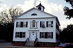 | century and incorporated as its own town in 1786. It is named for the Quinebaug River, or Brook Line, which forms its eastern boundary. Brooklyn was originally... 20 KB (1,210 words) - 21:03, 28 April 2024 |