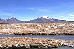
 | The Lauca River is a binational river. It originates in the Chilean Altiplano of the Arica and Parinacota Region, crosses the Andes and empties into Coipasa... 5 KB (415 words) - 14:22, 29 November 2023 |
 | metres (14,820 ft), in the Altiplano of Arica y Parinacota Region in the Lauca National Park. It has a surface area of about 21.5–22.5 square kilometres... 28 KB (3,052 words) - 22:56, 3 January 2024 |
(Rio Lauca, Río Lauca) • (BO) Rio ChusjavidaRío Chusjavida • 18°34′17″S 69°09′43″W / 18.57142°S 69.16196°W / -18.57142; -69.16196 (Río Chusjavida) •... 13 KB (1,286 words) - 03:20, 8 March 2022 |
 | Lake Chungará; numerous other lakes now forming the headwaters of the Rio Lauca sprang up within the deposit. Volcanic activity rebuilt the cone after... 79 KB (9,426 words) - 13:13, 15 January 2024 |
Incallajta Iskanwaya Puma Punku Lukurmata Sacambaya River Alcaya Jachaphasa Río Lauca Chullpas Tiahuanaco also known as Tiwanaku Bijela Tabija Butmir Daorson... 75 KB (6,377 words) - 08:49, 23 April 2024 |
 | 19°12′S 68°07′W / 19.200°S 68.117°W / -19.200; -68.117 Primary inflows Río Lauca Basin countries Bolivia Surface area 806 km2 (311 sq mi) Max. depth 3... 3 KB (191 words) - 14:27, 29 November 2023 |
 | The Canal Lauca is an artificial channel to divert the waters of the Lauca River westward through a canal and tunnel into the Azapa Valley for purposes... 5 KB (541 words) - 00:29, 18 April 2022 |
 | westward from the Andes to the Pacific Ocean between the Río Salado on the south and the Río Loa on the north, which included part of the Atacama Desert... 26 KB (3,983 words) - 06:47, 25 December 2023 |
pyroclastic shield in Bolivia. It is located on the Altiplano near to the Rio Lauca. The volcano is composed of ignimbrite, which has formed a shield. The... 2 KB (198 words) - 22:05, 28 November 2023 |
 | Gisbert, Teresa (1994). "El señorío de los Carangas y los chullpares del Río Lauca" (PDF) (in Spanish). Centro Bartolome de Las Casas. p. 433. Retrieved... 18 KB (2,137 words) - 17:02, 22 December 2022 |
 | and the southern paleolakes. Tauca was fed by the Río Grande de Lipez on the south, the Río Lauca on the northwest and the glaciers of the two cordilleras... 175 KB (18,692 words) - 19:16, 17 January 2024 |
 | (August 2015). "DIAGNÓSTICO DE DISPONIBILIDAD HÍDRICA EN LA CUENCA DEL RÍO LAUCA, REGIÓN DE ARICA Y PARINACOTA" (PDF). Dirección General de Aguas (in Spanish)... 9 KB (876 words) - 00:54, 7 December 2023 |
 | flank westward into the Lluta River; parts of the mountain drain into the Rio Lauca watershed to the east. Southwest of Taapaca lies Putre, the main town... 39 KB (4,361 words) - 02:13, 2 December 2023 |
Suches River Márquez River Laq'a Jawira Lauca River Sajama River Sabaya River Puka Mayu Río Grande de Lipez Río Colorado Rand McNally, The New International... 6 KB (465 words) - 08:06, 15 November 2023 |
 | severed from 1962 to 1975 in a dispute over the use of the waters of the Lauca River. Relations were resumed in 1975 but broken again in 1978 over the... 101 KB (5,616 words) - 13:41, 28 March 2024 |
Río Frías Formation (Spanish: Formación Río Frías) is a Middle Miocene geologic formation made up sedimentary rock located in Aysén Region, western Patagonia... 8 KB (447 words) - 23:30, 17 December 2021 |
Churches Arani, Cochabamba & Callapa, La Paz 1560 and 1745 9 Bolivia Rio Lauca Prehistoric Burial Towers Department of Oruro 1200–1600 10 Bosnia and... 19 KB (434 words) - 12:42, 10 October 2023 |
 | Protected areas of Chile (section Los Ríos Region) Sanctuary (Río Cruces y Chorocomayo) Cerro Coqui El Ajial Estero Quitralco Horcón de Piedra Humedal de Cutipay Humedales de Angachilla Humedales del Río Maullín... 12 KB (776 words) - 05:31, 3 May 2023 |
 | hydroelectric power plant in northern Chile. It takes water from the Canal Lauca and produces electrical power through a Pelton turbine. It lies 120 kilometres... 11 KB (974 words) - 18:30, 12 November 2023 |
 | Tarapacá. Retrieved 27 February 2018. Glassner, Martin Ira (1970). "The Rio Lauca: Dispute over an International River". Geographical Review. 60 (2): 192–207... 19 KB (2,253 words) - 04:36, 12 February 2024 |
 | protected areas. Those include: Eduardo Avaroa Andean Fauna National Reserve Lauca National Park Las Vicuñas National Reserve Llica National Park Llullaillaco... 6 KB (464 words) - 21:45, 21 March 2024 |
Juan Férnandez (1977) Torres del Paine (1978) Laguna San Rafael (1979) Lauca (1981) Araucarias (1983) La Campana-Peñuelas (1984) Cabo de Hornos (2005)... 9 KB (709 words) - 14:13, 24 April 2023 |
42 national parks in Chile covering a total area of 13,206,810 hectares. Lauca Volcán Isluga Llullaillaco Pan de Azúcar Nevado Tres Cruces Llanos de Challe... 14 KB (117 words) - 06:12, 17 April 2022 |
Huanquihue Group (category Los Ríos Region geography stubs) Huaynaputina Ticsani Tutupaca Yucamane Purupuruni Casiri Tacora Taapaca Parinacota Lauca Guallatiri Tata Sabaya Isluga Irruputuncu Olca-Paruma Aucanquilcha Azufre... 5 KB (499 words) - 21:15, 2 January 2024 |
 | generate Chungará Lake, located at 4500 meters above sea level. It and the Lauca River are shared with Bolivia, as well as the Lluta River. In the center-north... 211 KB (20,131 words) - 03:37, 24 April 2024 |
Oued Isser's Dam Hamiz Dam Calueque Dam Cambambe Dam Capanda Dam Gove Dam Lauca Dam Lomaum Dam Ruacana Dam Dieguoro Dam Ilauko Dam Bagre Dam Kompienga Dam... 33 KB (2,263 words) - 01:58, 6 March 2024 |
to Putre for enjoying the majestic Puna landscape of Lauca National Park. Southward from Lauca, Volcán Isluga National Park includes ceremonial sites... 58 KB (5,624 words) - 09:54, 22 April 2024 |
 | Mocho-Choshuenco (category Volcanoes of Los Ríos Region) Mocho-Choshuenco Archived August 24, 2009, at the Wayback Machine Cuenca del río Valdivia Archived September 27, 2007, at the Wayback Machine Rivera, Andrés;... 8 KB (853 words) - 09:56, 11 April 2024 |
volcano.si.edu. Retrieved 10 November 2013. "Global Volcanism Program | Río Murta". www.volcano.si.edu. Retrieved 10 November 2013. Siebert L, Simkin... 39 KB (596 words) - 12:01, 17 January 2024 |
 | meters, which underlies the city of Riobamba. It temporarily dammed the Río Chambo, causing an ephemeral lake. Chimborazo then erupted several times... 28 KB (3,043 words) - 17:18, 17 April 2024 |