 | Radio navigation or radionavigation is the application of radio frequencies to determine a position of an object on the Earth, either the vessel or an... 40 KB (5,305 words) - 20:06, 16 April 2024 |
 | transmitted along a line of sight by radio from satellites. The system can be used for providing position, navigation or for tracking the position of something... 42 KB (4,399 words) - 08:08, 5 May 2024 |
 | The field of navigation includes four general categories: land navigation, marine navigation, aeronautic navigation, and space navigation. It is also the... 61 KB (7,244 words) - 20:32, 3 May 2024 |
 | transmitter. In radio navigation systems such as GPS and VOR, a mobile navigation instrument receives radio signals from multiple navigational radio beacons whose... 140 KB (14,995 words) - 16:50, 8 May 2024 |
 | global-range radio navigation system, operated by the United States in cooperation with six partner nations. It was a hyperbolic navigation system, enabling... 22 KB (2,853 words) - 10:47, 21 March 2024 |
 | Non-directional beacon (redirect from Radio navigation beacon) aviation or marine navigational aid. NDB are in contrast to directional radio beacons and other navigational aids, such as low-frequency radio range, VHF omnidirectional... 25 KB (3,237 words) - 01:20, 7 March 2024 |
 | In navigation, a radio beacon or radiobeacon is a kind of beacon, a device that marks a fixed location and allows direction-finding equipment to find... 12 KB (1,464 words) - 11:42, 15 February 2024 |
 | written GEE, was a radio-navigation system used by the Royal Air Force during World War II. It measured the time delay between two radio signals to produce... 53 KB (7,600 words) - 03:44, 28 March 2024 |
 | and radio navigation systems, communications satellites, wireless computer networks and many other applications. Different frequencies of radio waves... 34 KB (3,769 words) - 18:07, 28 April 2024 |
aircraft used commercial AM radio stations for navigation, AM stations are still marked on U.S. aviation charts. Radio navigation played an important role... 71 KB (8,484 words) - 07:03, 2 April 2024 |
Global Positioning System (redirect from Navigation Signal Timing and Ranging Global Positioning System) satellite-based radio navigation system owned by the United States government and operated by the United States Space Force. It is one of the global navigation satellite... 178 KB (18,507 words) - 02:06, 9 May 2024 |
 | Celestial navigation, also known as astronavigation, is the practice of position fixing using stars and other celestial bodies that enables a navigator... 39 KB (5,086 words) - 05:13, 18 April 2024 |
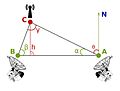
 | Hyperbolic navigation is a class of radio navigation systems in which a navigation receiver instrument is used to determine location based on the difference... 32 KB (4,976 words) - 20:14, 5 December 2023 |
latter case, the pilot will navigate exclusively using instruments and radio navigation aids such as beacons, or as directed under radar control by air traffic... 21 KB (3,057 words) - 22:50, 1 April 2023 |
Battle of the Beams (redirect from Knickebein (navigation)) Force (Luftwaffe) used a number of increasingly accurate systems of radio navigation for night bombing in the United Kingdom. British scientific intelligence... 30 KB (4,325 words) - 07:49, 5 May 2024 |
 | Area navigation (RNAV, usually pronounced as /ˈɑːrnæv/ "ar-nav") is a method of instrument flight rules (IFR) navigation that allows an aircraft to choose... 10 KB (1,283 words) - 02:10, 5 March 2024 |
Methods of electronic navigation include: Satellite navigation, satellite navigation systems Radio navigation, the application of radio frequencies to determine... 610 bytes (62 words) - 16:43, 12 July 2023 |
 | Instrument landing system (category Radio navigation) In aviation, the instrument landing system (ILS) is a precision radio navigation system that provides short-range guidance to aircraft to allow them to... 52 KB (6,142 words) - 04:00, 6 March 2024 |
Equipment codes (section Radio communication, navigation and approach aid equipment and capabilities) to the aircraft type code. A single letter is used to represent a radio navigational capability and transponder combination. On the ICAO flight plan form... 8 KB (1,003 words) - 17:41, 12 April 2024 |
 | Direction finding (redirect from Radio direction finder) of a radio source can be determined by measuring its direction from two or more locations. Radio direction finding is used in radio navigation for ships... 73 KB (10,463 words) - 04:13, 8 April 2024 |
 | A tactical air navigation system, commonly referred to by the acronym TACAN, is a navigation system used by military aircraft. It provides the user with... 14 KB (1,640 words) - 05:56, 27 April 2024 |
 | Alpha, also known as RSDN-20, is a Russian system for long range radio navigation. RSDN in Russian stands for Радиотехническая Система Дальней Навигации... 3 KB (414 words) - 20:44, 4 July 2022 |
 | LORAN (redirect from Loomis radio navigation) LORAN, short for long range navigation, was a hyperbolic radio navigation system developed in the United States during World War II. It was similar to... 40 KB (5,769 words) - 21:48, 2 May 2024 |
 | in a distance of 33 metres (36 yards) Frequency for radio navigation system Frequency for radio teleswitch system Frequency for AM-broadcasting and requiring... 48 KB (2,959 words) - 02:23, 25 April 2024 |
 | BeiDou (redirect from Compass navigation system) The BeiDou Navigation Satellite System (BDS; Chinese: 北斗卫星导航系统; pinyin: běidǒu wèixīng dǎoháng xìtǒng) is a satellite-based radio navigation system owned... 66 KB (5,650 words) - 05:02, 27 March 2024 |
 | VHF omnidirectional range (redirect from VHF Omni-directional Radio Range) short-range radio navigation system for aircraft, enabling aircraft with a receiving unit to determine its position and stay on course by receiving radio signals... 50 KB (6,461 words) - 21:01, 3 May 2024 |
 | clock for precise radio navigation in deep space. DSAC was designed to be orders of magnitude more stable than existing navigation clocks, with a drift... 10 KB (980 words) - 22:42, 23 January 2024 |
systems. Navigation systems using sonar have also been developed. Robots can also determine their positions using radio navigation. Electronic navigation Location... 9 KB (909 words) - 08:27, 30 January 2024 |
use of radio or other signal transmission to control the vehicle or vessel. In some cases, a combination of these methods is used. Navigation systems... 5 KB (551 words) - 19:50, 11 March 2024 |
look identical) as Navigation Plus. Those units are technically known as RNS-C/RNS-D and RNS-E, where RNS stands for "Radio Navigation System". The RNS-C... 9 KB (1,009 words) - 01:50, 16 September 2023 |