 | Remote sensing is the acquisition of information about an object or phenomenon without making physical contact with the object, in contrast to in situ... 62 KB (7,676 words) - 14:49, 11 April 2024 |
India's remote sensing program was developed with the idea of applying space technologies for the benefit of humankind and the development of the country... 12 KB (910 words) - 22:03, 10 April 2024 |
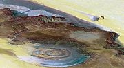 | Remote sensing is used in the geological sciences as a data acquisition method complementary to field observation, because it allows mapping of geological... 58 KB (6,685 words) - 15:33, 12 April 2024 |
A remote sensing software is a software application that processes remote sensing data. Remote sensing applications are similar to graphics software, but... 3 KB (317 words) - 12:14, 17 June 2023 |
Remote sensing techniques in archaeology are an increasingly important component of the technical and methodological tool set available in archaeological... 16 KB (2,072 words) - 03:19, 24 November 2023 |
Remote sensing may also refer to: Remote Sensing (journal), a scientific journal Remote sensing (archaeology) Remote sensing (geology) Remote sensing... 550 bytes (97 words) - 18:09, 13 November 2023 |
 | In electrical engineering, four-terminal sensing (4T sensing), 4-wire sensing, or 4-point probes method is an electrical impedance measuring technique... 5 KB (657 words) - 09:19, 22 January 2023 |
 | Topography (section Remote sensing) Giovanni Domenico Cassini, the great Italian astronomer. Even though remote sensing has greatly sped up the process of gathering information, and has allowed... 16 KB (1,956 words) - 22:26, 7 April 2024 |
| Radar remote sensing is a type of active remote Sensing which uses electromagnetic energy backscattered from ground targets to extract physical and dielectric... 2 KB (218 words) - 10:46, 3 March 2024 |
The Indian Institute of Remote Sensing is an institute for research, higher education and training in the field of remote sensing, geoinformatics and GPS... 7 KB (692 words) - 09:17, 9 December 2023 |
The Pakistan Remote Sensing Satellite (PRSS), is an earth observation optical satellite launched from China's Jiuquan Satellite Centre on 9 July 2018.... 6 KB (404 words) - 14:16, 22 April 2024 |
 | Landsat program (redirect from Land remote-sensing satellite) director of the United States Geological Survey, proposed the idea of a remote sensing satellite program to gather facts about the natural resources of our... 41 KB (3,813 words) - 21:11, 5 January 2024 |
 | Thermal remote sensing is a branch of remote sensing in the thermal infrared region of the electromagnetic spectrum. Thermal radiation from ground objects... 13 KB (1,272 words) - 14:24, 19 February 2024 |
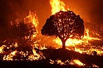 | Wildfire (redirect from Remote sensing of wildfires) of Remote Sensing, GIS, and Information Distribution for Wildfire Detection and Management" (PDF). Photogrammetric Engineering and Remote Sensing. 64... 187 KB (19,244 words) - 13:21, 18 April 2024 |
 | European Remote Sensing satellite (ERS) was the European Space Agency's first Earth-observing satellite programme using a polar orbit. It consisted of... 9 KB (1,003 words) - 17:39, 22 February 2024 |
for space exploration. ISRO has the world's largest constellation of remote-sensing satellites and operates the GAGAN and IRNSS (NavIC) satellite navigation... 234 KB (17,952 words) - 16:22, 24 April 2024 |
 | Geography (section Remote sensing) taking mixed-methods approaches. Common techniques include cartography, remote sensing, interviews, and surveying. Geography is a systematic study of the Earth... 91 KB (9,327 words) - 08:17, 13 April 2024 |
National Remote Sensing Centre (Hindi: राष्ट्रीय सुदूर संवेदन केन्द्र), or NRSC, located in Hyderabad, Telangana is one of the centres of the Indian Space... 2 KB (99 words) - 09:38, 30 September 2023 |
 | Archaeology (section Remote sensing) reflected. Satellite imagery is an example of passive remote sensing. Here are two active remote sensing instruments: Lidar: Lidar (light detection and ranging)... 133 KB (13,774 words) - 16:09, 21 April 2024 |
 | Amazon rainforest (section Remote sensing) Furthermore, remote sensing is the best and perhaps only possible way to study the Amazon on a large scale. The use of remote sensing for the conservation... 109 KB (10,485 words) - 03:40, 9 April 2024 |
Institute of Electrical and Electronics Engineers (redirect from IEEE Geoscience and Remote Sensing Society) Society Engineering in Medicine and Biology Society Geoscience and Remote Sensing Society Industrial Electronics Society Industry Applications Society... 22 KB (1,840 words) - 02:48, 11 April 2024 |
 | time scale. These changes increased political interest in gathering remote-sensing data on the Earth itself and stimulated the science of climatology.... 38 KB (1,190 words) - 11:41, 17 April 2024 |
Remote sensing in oceanography is a widely used observational technique which enables researchers to acquire data of a location without physically measuring... 33 KB (4,337 words) - 11:39, 3 March 2024 |
Ground truth (section Remote sensing) truth data enables calibration of remote-sensing data, and aids in the interpretation and analysis of what is being sensed. Examples include cartography,... 9 KB (1,208 words) - 23:14, 11 January 2024 |
Ensemble learning (section Remote sensing) the major applications of Earth observation satellite sensors, using remote sensing and geospatial data, to identify the materials and objects which are... 52 KB (6,571 words) - 19:53, 17 April 2024 |
Computational geophysics (section Remote sensing) and geological modelling. In addition to modelling, some problems in remote sensing fall within the scope of computational geophysics such as tomography... 7 KB (767 words) - 13:07, 3 March 2024 |
 | Ocean color (section Ocean color remote sensing) or red in some cases. This field of study developed alongside water remote sensing, so it is focused mainly on how color is measured by instruments (like... 41 KB (4,274 words) - 12:29, 2 March 2024 |
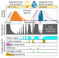 | Atmospheric window (section In remote sensing) surface to leave to space. Atmospheric windows are useful for astronomy, remote sensing, telecommunications and other science and technology applications. In... 9 KB (825 words) - 12:44, 3 January 2024 |
Flash drought (category Remote sensing) explored their impacts on agriculture, ecosystems, and water resources. Remote sensing data, such as satellite-derived measurements of soil moisture, evapotranspiration... 4 KB (353 words) - 13:45, 28 December 2023 |
 | Earth observation satellite (redirect from Remote sensing satellite) An Earth observation satellite or Earth remote sensing satellite is a satellite used or designed for Earth observation (EO) from orbit, including spy satellites... 15 KB (1,586 words) - 12:16, 1 April 2024 |