 | Porcupine abyssal plain. The Rockall Basin (also known as the Hatton Rockall Basin) is a large (c. 800 km by 150 km) sedimentary basin that lies beneath the... 9 KB (988 words) - 13:20, 31 March 2023 |
 | Rockall (/ˈrɒkɔːl/) is an uninhabitable granite islet in the North Atlantic Ocean. The United Kingdom claims that Rockall lies within its territorial... 71 KB (7,536 words) - 17:54, 28 April 2024 |
Rockall is a small, uninhabited, remote rocky islet in the North Atlantic Ocean. Rockall may also refer to: Rockall Basin, sedimentary basin to the west... 956 bytes (164 words) - 07:07, 27 May 2023 |
Rockall Bank to the east. The basin contains about 4,000 m of sediments of probable Cretaceous to Cenozoic age. Its relationship to the Rockall Basin... 4 KB (419 words) - 01:36, 25 October 2023 |
on the Beaufort scale), if any (e.g., "There are warnings of gales in Rockall, Malin, Hebrides, Bailey, and Fair Isle"). This sometimes follows the opposite... 49 KB (5,891 words) - 10:53, 8 April 2024 |
 | Slope MPA(NC)". NatureScot. Retrieved 7 October 2020. "SiteLink: Hatton-Rockall Basin MPA(NC)". NatureScot. Retrieved 7 October 2020. "SiteLink: Loch Carron... 23 KB (1,600 words) - 16:36, 15 December 2023 |
 | Several states have claimed interests over the sea bed adjoining Rockall, an uninhabitable granite islet which is located within the exclusive economic... 15 KB (1,890 words) - 16:37, 9 April 2024 |
 | Cheshire Basin Worcester Basin Hampshire Basin Cardigan Bay Basin St George's Channel Basin Wessex Basin Rockall Basin Porcupine Basin The negative anomaly... 6 KB (756 words) - 23:00, 29 January 2024 |
 | also been recorded from pelagic waters such as off Hebrides and on Rockall Basin as late as in 2000s. Right whales have also on rare occasion been observed... 111 KB (11,236 words) - 03:31, 15 March 2024 |
 | Forth Banks Complex (FOF) Geikie Slide and Hebridean Slope (GSH) Hatton-Rockall Basin (HRB) North-east Faroe-Shetland Channel (NEF) North-west Orkney (NWO)... 14 KB (986 words) - 22:48, 2 March 2024 |
 | Porcupine Seabight (redirect from Porcupine Basin) McDonnell, A.; Bailey, W.R. (2006). "The evolution of the Porcupine and Rockall basins, offshore Ireland: the geological template for carbonate mound development"... 15 KB (1,476 words) - 06:41, 17 February 2024 |
(200–500m), bathyal zone (500–2000m), and abyssal zone (2000–4000m), in the Rockall Basin, Porcupine Seabight, and Celtic Sea. Taxonomy follows Taxonomy of the... 21 KB (2,157 words) - 20:15, 9 February 2024 |
sedimentary basins of Britain and Ireland are numerous, occurring beneath both the land surface of these islands and the surrounding seas. Sedimentary basins (not... 11 KB (301 words) - 05:24, 8 January 2023 |
 | the smaller but similar Ymir Ridge, form the northern boundary to the Rockall Basin, a mainly Mesozoic rift structure. The current form of the ridge is... 2 KB (272 words) - 03:14, 10 July 2021 |
 | and growth of sill complexes: insights using 3D seismic from the North Rockall Trough". Bulletin of Volcanology. 66 (4): 364–375. Bibcode:2004BVol...66... 8 KB (924 words) - 18:11, 22 February 2024 |
 | Atlantic Ocean (redirect from Atlantic basin) extension of the crust and formations of troughs and sedimentary basins. The Rockall Trough opened between 105 and 84 million years ago although along... 113 KB (12,337 words) - 23:35, 23 April 2024 |
1,500 m (4,900 ft) deep. It's found as far north as Ireland, in the Rockall Basin, and as far south as Namibia. There are more specimens in the southeast... 5 KB (486 words) - 04:09, 27 September 2023 |
 | Nankai Trough Northumberland Trough Okinawa Trough in the East China Sea Rockall Trough and others along the rift of the mid-oceanic ridge Salton Trough... 2 KB (190 words) - 15:36, 25 June 2023 |
 | Geology of the Faroe Islands (redirect from Faroes-Rockall Plateau) eruptions built up a huge basalt plateau that covered almost the entire Faroe–Rockall region, together with the southeastern part of Greenland. In simple terms... 4 KB (525 words) - 16:39, 6 October 2023 |
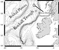
| The Anton Dohrn Seamount is a guyot in the Rockall Trough in the northeast Atlantic. It is 1.8 kilometres (1.1 mi) high and is topped with pinnacles,... 27 KB (2,951 words) - 00:32, 21 March 2024 |
 | Azores (following the Mid-Atlantic Ridge); and the area around the Rockall Basin, Britain, Ireland, and (during winter) northern Portugal. A single specimen... 48 KB (5,011 words) - 06:07, 27 April 2024 |
Slyne-Erris Trough (category Sedimentary basins of Europe) links the Erris and Porcupine Basins. The Erris Trough or Erris Basin is a half-graben that runs parallel with the Rockall Basin and is separated from it by... 2 KB (319 words) - 21:01, 22 July 2023 |
 | Quality of Life survey. Rockall is a small rocky islet in the North Atlantic which was declared part of Scotland by the Island of Rockall Act 1972. However... 74 KB (5,066 words) - 12:38, 7 April 2024 |
 | Greenland. By c. 83 Mya spreading had begun in the North Atlantic between the Rockall Plateau, a continental fragment sitting on top of the Eurasian Plate, and... 47 KB (4,966 words) - 23:14, 1 March 2024 |
 | Shetland Islands South: Mull of Galloway, Dumfries and Galloway West: Either Rockall (annexed in 1972 to the former Inverness-shire), the international status... 48 KB (4,949 words) - 06:13, 2 May 2024 |
 | during storms, rendering them uninhabitable. Finally, there is remote Rockall, which is 367 kilometres (228 mi) to the west of North Uist. It is a small... 32 KB (2,927 words) - 21:13, 29 November 2023 |
hotspot areas on Europe's deep-ocean margin, including the Scandinavian, Rockall-Porcupine and central Mediterranean margins, and there remain many questions... 35 KB (4,235 words) - 08:23, 26 February 2024 |
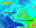
| level at its highest, lies between the deep-water Porcupine Seabight and Rockall Trough. The name comes from the bank's discovery in 1862 by HMS Porcupine... 3 KB (331 words) - 12:22, 23 March 2024 |
 | Denmark Norge – On 28 June the ship ran aground on Helen's Reef near Rockall. 635 people were lost; 160 survivors spent up to eight days in open boats... 86 KB (1,811 words) - 15:01, 2 May 2024 |
 | chiefly on the Rockall Bank and on the shelf break north and west of Scotland. The Porcupine Seabight, the southern end of the Rockall Bank, and the shelf... 30 KB (3,734 words) - 17:41, 4 February 2024 |