 | (AD 43–410) that Britannia was a province of the Roman Empire. It is estimated that about 2,000 mi (3,200 km) of paved trunk roads (surfaced roads running between... 39 KB (3,425 words) - 21:01, 15 February 2024 |
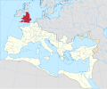 | Roman Britain was the territory that became the Roman province of Britannia after the Roman conquest of Britain, consisting of a large part of the island... 117 KB (13,292 words) - 07:10, 26 April 2024 |
 | used by the Romans in classical antiquity, the Latin Britannia was the name variously applied to the British Isles, Great Britain, and the Roman province... 35 KB (3,714 words) - 17:59, 16 April 2024 |
Roman Roads in Britain (1903) was a book written by Thomas Codrington and published by the Society for Promoting Christian Knowledge in autumn 1903. Codrington... 4 KB (388 words) - 10:46, 3 March 2024 |
 | The conquered territory became the Roman province of Britannia. Attempts to conquer northern Britain (Caledonia) in the following centuries were not successful... 41 KB (4,924 words) - 00:45, 26 February 2024 |
 | Watling Street (redirect from A5183 road) one of the main Roman roads in Britannia (Roman-governed Great Britain during the Roman Empire). The route linked Dover and London in the southeast, and... 40 KB (2,652 words) - 15:17, 10 May 2024 |
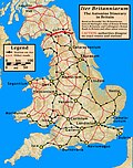
 | official communications, and trade goods. Roman roads were of several kinds, ranging from small local roads to broad, long-distance highways built to... 61 KB (7,734 words) - 19:36, 9 May 2024 |
by T. Rex (series 3). In March 2023, the series was cancelled after three seasons. Britannia is set in 43 AD, when the Romans invaded Britain. Julius... 32 KB (1,575 words) - 20:51, 13 February 2024 |
Margary numbers (category Roman roads in Britannia) Ivan Margary to catalogue known and suspected Roman roads in Britain in his 1955 work The Roman Roads of Britain. They remain the standard system used... 11 KB (411 words) - 01:06, 2 April 2024 |
 | civitates during the Roman era, the most famous being Camulodunum, modern day Colchester, the first capital of the Roman province of Britannia, and Londinium... 14 KB (420 words) - 22:19, 2 January 2024 |
 | Fosse Way (category Roman roads in England) The Fosse Way was a Roman road built in Britain during the first and second centuries AD that linked Isca Dumnoniorum (Exeter) in the southwest and Lindum... 20 KB (2,035 words) - 00:26, 28 April 2024 |
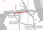 | Stanegate (category Roman roads in England) northern version, indicating a stone or paved road. The Stanegate differed from most other Roman roads in that it often followed the easiest gradients... 11 KB (1,386 words) - 16:38, 26 February 2024 |
 | other roads nearby such as Nine Mile Ride, which runs parallel to the Roman road about a mile away but at a lower height. The London portion of the road was... 7 KB (787 words) - 14:27, 28 November 2023 |
 | Calleva Atrebatum (redirect from Silchester Roman Town) walled town in the Roman province of Britannia, at a major crossroads of the roads of southern Britain. The modern village of Silchester in Hampshire,... 37 KB (3,910 words) - 20:17, 14 March 2024 |
 | Stamford Bridge, East Riding of Yorkshire (category Villages in the East Riding of Yorkshire) Derventio (disambiguation) See Roman roads in Britannia > Main routes See Margary numbers > Main routes The route of Cade's Road can clearly be seen heading... 22 KB (2,611 words) - 15:13, 1 April 2024 |
 | Hadrian's Wall (redirect from Hadrian's Wall - Frontiers of the Roman Empire) the Roman Wall, Picts' Wall, or Vallum Aelium in Latin) is a former defensive fortification of the Roman province of Britannia, begun in AD 122 in the... 69 KB (7,713 words) - 16:20, 4 May 2024 |
 | Ermine Street (redirect from Old North Road) Ermine Street is a major Roman road in England that ran from London (Londinium) to Lincoln (Lindum Colonia) and York (Eboracum). The Old English name... 9 KB (1,019 words) - 13:14, 17 December 2023 |
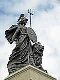
Look up Britannia or Brittania in Wiktionary, the free dictionary. Britannia is the Latin name for Britain, used as the female personification of Britain... 6 KB (788 words) - 18:04, 26 April 2024 |
 | Eboracum (redirect from Roman York) [ɛbɔˈraːkum]) was a fort and later a city in the Roman province of Britannia. In its prime it was the largest town in northern Britain and a provincial capital... 35 KB (3,899 words) - 14:48, 1 April 2024 |
 | Stane Street (Chichester) (category Roman roads in England) width of the paved road is 7.4 m (24 ft), or 25 Roman pedes. This is wider than the average 6.51 m (21.4 ft) or 22 pedes for Roman roads in Britain. The distance... 59 KB (6,365 words) - 12:52, 24 September 2023 |
 | Antonine Itinerary (category Roman itineraries) various roads. Seemingly based on official documents, possibly in part from a survey carried out under Augustus, it describes the roads of the Roman Empire... 14 KB (927 words) - 12:23, 8 April 2024 |
 | the Roman conquest of Britannia, the Roman armies under Quintus Petillius Cerialis and Gnaeus Julius Agricola campaigned against the Caledonians in the... 67 KB (8,771 words) - 03:49, 1 May 2024 |
 | Dere Street (category Roman roads in Scotland) was the Romans' major route for communications and supplies to the north and to Scotland. Portions of its route are still followed by modern roads, including... 25 KB (2,027 words) - 10:41, 29 January 2024 |
 | Devil's Causeway (category Roman roads in England) The Devil's Causeway is a Roman road in Northumberland, in North East England. It branches off Dere Street north of Corbridge and can be traced through... 7 KB (750 words) - 17:52, 19 December 2023 |
 | A partial list of Roman place names in Great Britain. This list includes only names documented from Roman times. For a more complete list including later... 16 KB (404 words) - 23:31, 16 March 2024 |
 | Akeman Street (category Roman roads in England) be: Roman road to Aquamannia Roman road to Bath Akeman Street (Cambridgeshire) Roman Britain Roman roads in Britain RAF Akeman Street ...the Roman spa... 5 KB (477 words) - 10:22, 26 November 2023 |
| many Roman sites in Great Britain that are open to the public. There are also many sites that do not require special access, including Roman roads, and... 12 KB (1,175 words) - 10:23, 11 November 2023 |
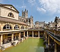 | Aquae Sulis (category Roman religious sites in England) small town in the Roman province of Britannia. Today it is the English city of Bath, Somerset. The Antonine Itinerary register of Roman roads lists the... 11 KB (1,266 words) - 20:09, 3 September 2023 |
| It is not believed that the road continued north of Hadrian's Wall. Roman roads in Britain Roman Britain Malton Roman Fort was previously known as Derventio... 9 KB (856 words) - 22:54, 18 September 2023 |
 | boundaries and labels, making it also a type of political map. In addition to roads and boundaries, road maps often include points of interest, such as prominent... 12 KB (1,462 words) - 15:59, 14 April 2024 |