 | Route 381 is a provincial highway located in the Capitale-Nationale and Saguenay–Lac-Saint-Jean regions of Quebec. It runs from Baie-Saint-Paul (in Charlevoix)... 2 KB (92 words) - 05:38, 28 January 2023 |
381: BR-381 Newfoundland and Labrador Route 381 Quebec Route 381 Saskatchewan Highway 381 Japan National Route 381 Interstate 381 Georgia State Route 381... 1 KB (105 words) - 22:55, 4 April 2024 |
 | Lower North Shore". Gouvernement du Québec. Retrieved 25 June 2018. Google (March 24, 2023). "Route 138 in Quebec" (Map). Google Maps. Google. Retrieved... 36 KB (956 words) - 11:13, 11 May 2024 |
 | Capitale-Nationale region, in Quebec, Canada. The municipality lies along Quebec Route 381 at the intersection with Quebec Route 138. Saint-Urbain was one... 7 KB (314 words) - 06:04, 26 February 2024 |
 | Peninsula. This highway is known as the Navigator's Route. It passes through the Montérégie, Centre-du-Québec, Chaudière-Appalaches, Bas-Saint-Laurent and Gaspésie... 37 KB (580 words) - 14:23, 9 March 2024 |
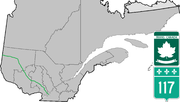 | Route 117, the Trans Canada Highway Northern Route, is a provincial highway within the Canadian province of Quebec, running between Montreal and the Quebec/Ontario... 18 KB (747 words) - 22:51, 13 May 2024 |
Réaménagement de la route 185 en autoroute". Archived from the original on 2018-09-25. Retrieved 2016-10-26. Canada portal Roads portal Transports Québec autoroutes... 8 KB (547 words) - 20:07, 4 May 2024 |
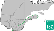
 | List of Quebec provincial highways Ministère des transports, "Distances routières", page 74-75, Les Publications du Québec, 2005 Provincial Route Map (Courtesy... 3 KB (207 words) - 12:28, 28 March 2023 |
 | restaurants, gift shops, a school and a hospital. It is also home to a huge Hydro-Québec employee facility, from where guided tours to the Robert-Bourassa power... 8 KB (597 words) - 05:39, 28 January 2023 |
 | transports, "Distances routières", page (?), Les Publications du Québec, 2005 Official Transports Quebec Map (in French) Route 382 on Google Maps v t e... 3 KB (90 words) - 01:56, 25 January 2023 |
 | Canadian province of Quebec, located in Le Fjord-du-Saguenay Regional County Municipality. This municipality is located on Route 381 relatively near Saguenay... 7 KB (114 words) - 18:29, 5 December 2023 |
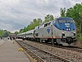 | Adirondack (train) (category Amtrak routes) Rouses Point. Trains take approximately 11 hours to travel the 381-mile (613 km) route. Canadian track maintenance issues led to the unscheduled suspension... 30 KB (2,282 words) - 01:11, 14 May 2024 |
 | James Bay Road (redirect from Route de la Baie James) Canadian Shield in northwestern Quebec and reaches into the James Bay region. It starts in Matagami as an extension of Route 109 and ends at Radisson. The... 6 KB (560 words) - 12:39, 15 November 2023 |
 | transports, "Distances routières", page (?), Les Publications du Québec, 2005 Official Transports Quebec Map (in French) route 373 on Google Maps v t e... 2 KB (87 words) - 01:47, 25 January 2023 |
the Central Maine and Québec Railway Canada Incorporated with offices in Sherbrooke, QC, and were registered with Revenue Québec on February 14, 2014.... 14 KB (1,337 words) - 04:08, 8 December 2023 |
 | Québec. Archived from the original on 16 October 2014. Retrieved 25 April 2010. Québec, Institut de la statistique du (24 February 2023). "Québec's international... 80 KB (7,802 words) - 04:33, 23 April 2024 |
 | Trans-Labrador Highway (redirect from Newfoundland and Labrador Route 500) as Route 516. Phase II also included other branch routes: Route 513 to St. Lewis Route 514 to Charlottetown and Pinsent Arm A segment of Quebec Route 138... 26 KB (1,552 words) - 23:45, 14 February 2024 |
 | Charlevoix Regional County Municipality (redirect from Charlevoix County Regional Municipality, Quebec) Capitale-Nationale region of Quebec, Canada. The seat is Baie-Saint-Paul. There are 7 subdivisions within the RCM: Highways and numbered routes that run through the... 4 KB (139 words) - 18:06, 12 January 2024 |
 | Commission de toponymie du Québec. The summit of Mont du Lac à Moïse is located at: 0.8 kilometres (0.50 mi) southwest of route 381; 3.1 kilometres (1.9 mi)... 9 KB (758 words) - 22:31, 17 September 2023 |
 | the Charlevoix Regional County Municipality. The entire area west of Quebec Route 381, which bisects the territory, is part of the Laurentides Wildlife Reserve... 6 KB (286 words) - 05:21, 28 January 2023 |
 | Gatineau (redirect from Gatineau, Québec) houses the main campus of the Université du Québec en Outaouais (UQO), part of the Université du Québec network. The UQO counts over 5,500 students,... 89 KB (7,535 words) - 14:43, 9 May 2024 |
(Below FL290) Sept-Iles 135.55 & 381.9 (Below FL290) Sherbrooke 132.55 & 226.0 (Below FL290) Timmins 133.975 & 381.4 (FL290 & above) Trois-Rivières 128... 5 KB (760 words) - 21:22, 9 June 2023 |
 | Le Golfe-du-Saint-Laurent Regional County Municipality (redirect from Le Golfe-du-Saint-Laurent Regional County Municipality, Quebec) equivalent territories in Quebec "Le Golfe-du-Saint-Laurent (Municipalité régionale de comté)" (in French). Commission de toponymie du Québec. Retrieved 2010-10-10... 13 KB (656 words) - 15:35, 26 April 2024 |
Saguenay-Lac-Saint-Jean, in the province of Quebec, in Canada. The "Bras d'Hamel" valley is served mainly by the route 381 which runs along its entire course for... 7 KB (705 words) - 00:43, 2 February 2023 |
Capitale-Nationale, in the province of Quebec, in Canada. The lower part of this valley is mainly served by the route 381 (boulevard de Monseigneur-De Laval)... 8 KB (1,041 words) - 12:52, 14 December 2021 |
territory of Lac-Ministuk of the same MRC; the city of Saguenay (city). The route 381 serves the western side of the Ha! Ha! River And cut the lower part of... 8 KB (887 words) - 21:14, 15 December 2021 |
 | Villages of Quebec. In 1632, Samuel de Champlain, founder of New France, gave his name to the Champlain River. The Commission de toponymie du Québec has noted... 18 KB (1,693 words) - 13:27, 2 May 2024 |
List of highways numbered 1 (redirect from State Route 1) Nova Scotia Trunk 1 Northwest Territories Highway 1 Quebec Route 1 (former) Yukon Highway 1 Chile Route 1 G1 Expressway G1N Expressway G0111 Expressway S01... 20 KB (1,261 words) - 10:34, 3 May 2024 |
 | of Quebec, in Canada. It is located on the east side of Lake Ha! Ha! into which it drains. The southern portion of the lake is served by Route 381, which... 6 KB (732 words) - 17:18, 29 April 2023 |
Corey attempts to juggle his job at the shop with running his new bar. 381 18 "Hot Dam" March 19, 2015 (2015-03-19) N/A Items appraised include a set... 393 KB (538 words) - 00:16, 3 May 2024 |