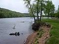
 | The Saint Croix National Scenic Riverway is a federally protected system of riverways located in eastern Minnesota and northwestern Wisconsin. It protects... 5 KB (400 words) - 16:58, 13 February 2024 |
 | The river is a National Scenic Riverway under the protection of the National Park Service. A hydroelectric plant at the Saint Croix Falls Dam supplies... 29 KB (3,082 words) - 22:45, 11 April 2024 |
 | watercourses; for example, the Saint Croix National Scenic Riverway includes the Namekagon River as well as the St. Croix River. Rivers are managed by one... 58 KB (272 words) - 23:40, 6 March 2024 |
 | Airport (KRNH) serves the county and surrounding communities. Saint Croix National Scenic Riverway (part) Polk County - north Barron County - northeast Dunn... 21 KB (1,600 words) - 19:33, 26 April 2024 |
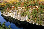
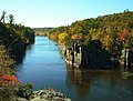 | Interstate Park (redirect from Dalles of the St. Croix River) St. Croix Falls, Wisconsin are adjacent to the park. Interstate Park is within the Saint Croix National Scenic Riverway and the Ice Age National Scientific... 30 KB (3,402 words) - 22:21, 1 August 2023 |
 | Saint Croix National Scenic Riverway, construction could only proceed following federal legislation which granted an exemption to the Wild and Scenic... 5 KB (417 words) - 19:45, 13 October 2023 |
 | corridor is part of the Saint Croix National Scenic Riverway. The Kettle River is designated a State Wild and Scenic River. List of National Historic Landmarks... 16 KB (1,613 words) - 23:10, 8 September 2023 |
the southernmost public park on the Saint Croix National Scenic Riverway. St. Croix Bluffs Regional Park on St. Croix Trail opened in 1996 on a site purchased... 3 KB (322 words) - 22:26, 4 February 2019 |
 | Wild River State Park (redirect from Saint Croix Wild River State Park) as early as the 1930s. However it was the creation of the Saint Croix National Scenic Riverway in 1968 that finally prompted action by both parties. The... 19 KB (1,906 words) - 00:13, 27 March 2024 |
 | Croix River, with Chisago County, Minnesota, on the opposite shore. Polk County, Wisconsin, is to the south. The Saint Croix National Scenic Riverway... 7 KB (543 words) - 05:24, 18 July 2023 |
 | Minnesota's early economy. The sawmills at Saint Anthony Falls and logging centers of Pine City, Marine on St. Croix, Stillwater, and Winona processed vast... 165 KB (14,581 words) - 14:58, 3 May 2024 |
| 73rd and 74th Assembly districts. Saint Croix National Scenic Riverway near Osceola, Wisconsin downtown St. Croix Falls Polk County Courthouse "Assembly... 8 KB (222 words) - 17:23, 26 March 2024 |
 | points are the St. Croix River (Wisconsin-Minnesota). It is home to the Park Headquarters for the St. Croix National Scenic Riverway, and it lies adjacent... 19 KB (1,421 words) - 00:46, 27 March 2024 |
 | Pierce County, Wisconsin (category Minneapolis–Saint Paul) Minnesota – southwest Washington County, Minnesota – west Saint Croix National Scenic Riverway (part) As of the census of 2020, the population was 42,212... 16 KB (1,045 words) - 19:32, 26 April 2024 |
 | The Namekagon River, a tributary of the St. Croix River and part of the Saint Croix National Scenic Riverway, passes through the town. As of the census... 7 KB (599 words) - 21:43, 18 July 2023 |
 | States. It is fed by the Namekagon River and is part of the Saint Croix National Scenic Riverway. The Lumberjack Bowl is a large bay on Lake Hayward that... 4 KB (144 words) - 18:06, 22 August 2022 |
miles (89 km) along the St. Croix River. It is managed as a wilderness buffer for the Saint Croix National Scenic Riverway. On the east the state forest... 2 KB (93 words) - 23:17, 11 May 2023 |
 | Snowmobiling is limited to the frozen lake surfaces and the Chain of Lakes Scenic Trail through the center of the Kabetogama Peninsula. Trail maps can be... 38 KB (4,181 words) - 13:58, 12 February 2024 |
 | from take-out points. Public boat ramp. This section of the Saint Croix National Scenic Riverway is officially a "slow-speed" zone. Jetskis are not permitted... 6 KB (632 words) - 01:46, 3 August 2023 |
 | surrounding communities. L.O. Simenstad Municipal Airport (KOEO). Saint Croix National Scenic Riverway (part) As of the census of 2020, the population was 44,977... 18 KB (1,207 words) - 19:32, 26 April 2024 |
and ten national wild and scenic rivers administered as distinct units of the National Park System. There are many more national wild and scenic rivers... 105 KB (1,726 words) - 17:08, 6 May 2024 |
 | Boundary Waters Canoe Area Wilderness (category Superior National Forest) and removing from wilderness designation a number of large scenic lakes such as La Croix, Basswood, Saganaga, and Seagull. The bill was strongly opposed... 44 KB (4,491 words) - 07:54, 3 February 2024 |
 | Namekagon River (category Wild and Scenic Rivers of the United States) the United States. Its course is protected as part of the St. Croix National Scenic Riverway. According to the Geographic Names Information System, the river's... 10 KB (899 words) - 01:59, 15 August 2023 |
 | List of areas in the United States National Park System Saint Croix National Scenic Riverway "Mississippi National River and Recreation Area". Geographic... 42 KB (1,114 words) - 15:45, 18 February 2024 |
 | 30 of Wisconsin's 72 counties. The Saint Croix National Scenic Riverway protects 252 miles (406 km) of the St. Croix and Namekagon Rivers. Wisconsin has... 39 KB (3,569 words) - 17:22, 9 April 2024 |
 | west Douglas County - northwest Chequamegon National Forest (part) Saint Croix National Scenic Riverway (part) As of the census of 2020, the population... 19 KB (1,489 words) - 19:33, 26 April 2024 |
 | and 1935. The state's boundaries include the Mississippi River and St. Croix River in the west, and the Menominee River in the northeast.[citation needed]... 176 KB (14,604 words) - 05:33, 4 May 2024 |
 | River. The largest state park in size is the 33,895 acre (13,717 ha) Saint Croix State Park. Headwaters of the Mississippi River at Itasca State Park... 18 KB (1,855 words) - 19:15, 8 August 2023 |
 | North Country Trail (redirect from North country national scenic trail) districts, and passes through Pattison State Park followed by Saint Croix National Scenic Riverway. Later there is an extensive hike on wilderness footpaths... 43 KB (4,031 words) - 19:52, 10 April 2024 |
 | with 118 acres (48 ha) to Saint Croix State Park with 34,037 acres (13,774 ha). Two parks include resources listed as National Natural Landmarks (Big Bog... 90 KB (2,841 words) - 09:47, 14 April 2024 |