 | Salmon–Challis National Forest is located in east central sections of the U.S. state of Idaho. At 4,235,940 acres (6,618.66 sq mi, or 17,142.24 km2) it... 7 KB (485 words) - 09:28, 18 September 2023 |
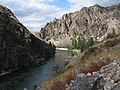
 | Settlements located along the Salmon River include Stanley, Clayton, Challis, Salmon, Riggins, and White Bird. Redfish Lake and Little Redfish Lake, which... 27 KB (1,925 words) - 17:42, 25 November 2023 |
 | Frank Church–River of No Return Wilderness (category Salmon-Challis National Forest) Payette National Forest (33.45%) Challis National Forest (21.78%) Salmon National Forest (17.81%) (now administratively combined with Challis NF, so that... 16 KB (1,538 words) - 01:35, 6 December 2023 |
 | Lemhi Pass (category Salmon-Challis National Forest) part of the Bitterroot Range in the Rocky Mountains and within Salmon-Challis National Forest. The pass lies on the Montana-Idaho border on the continental... 7 KB (734 words) - 12:15, 21 February 2024 |
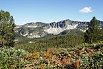
 | Borah Peak (category Salmon-Challis National Forest) located in the central section of the Lost River Range, within the Challis National Forest in eastern Custer County. On February 11, 2021, the USGS officially... 11 KB (830 words) - 20:24, 28 September 2023 |
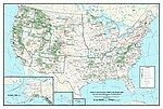 | with hyphenated names, such as Salmon–Challis National Forest, are considered to be a single national forest. Forests that are managed together under... 116 KB (2,713 words) - 14:10, 30 January 2024 |
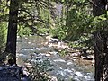 | States. It originates in the Salmon River Mountains, in the Salmon-Challis National Forest, and flows south to its confluence at Sunbeam, about 10 miles... 4 KB (129 words) - 16:22, 11 January 2023 |
 | Salmon River". Salmon-Challis National Forest. US Forest Service. Retrieved June 18, 2019. Middle Fork of the Salmon River, USDA Forest Service "Frank Church... 14 KB (1,098 words) - 00:26, 15 December 2023 |
 | Sawtooth Range (Idaho) (category Salmon-Challis National Forest) within the Sawtooth Wilderness, part of the Sawtooth National Recreation Area and Sawtooth National Forest. The mountains were named for their jagged peaks... 10 KB (930 words) - 08:12, 12 June 2023 |
 | Goldbug Hot Springs (category Salmon-Challis National Forest) Hot Springs is a hot spring located in the Salmon-Challis National Forest about 20 miles south of Salmon, Idaho. The spring is along Warm Spring Creek... 9 KB (618 words) - 14:50, 2 February 2022 |
 | Freeman Peak (category Salmon-Challis National Forest) Range. The peak is situated 12 miles northeast of Salmon, Idaho, in the Salmon–Challis National Forest. The summit lies less than one-half mile west of... 5 KB (368 words) - 22:44, 3 July 2023 |
Dickey Peak (Idaho) (category Salmon-Challis National Forest) Dickey Peak is a mountain in Custer County, Idaho. At 3397m, it's the 14th highest peak in Idaho that has at least 500m of topographic prominence. "Dickey... 1 KB (70 words) - 04:35, 4 September 2022 |
 | constituted much of the present-day Salmon-Challis and Boise National Forests. These lands were split into separate National Forests by executive order on June... 112 KB (10,798 words) - 10:42, 31 December 2023 |
 | (2,145 m) Banner Creek Summit at the forest's boundary with Salmon-Challis National Forest. "Boise National Forest". Geographic Names Information System... 62 KB (5,842 words) - 02:24, 9 January 2024 |
 | U.S. Route 93 (redirect from U.S. Route 93 Alternate (Shoshone-Challis, Idaho)) portions of the Lewis and Clark Trail and passes through the Salmon-Challis National Forest before entering Montana. US 93 enters Montana from Idaho at... 28 KB (2,723 words) - 05:00, 24 March 2024 |
 | Hells Canyon National Recreation Area and the Hells Canyon to the west, Salmon-Challis National Forest to the east, Boise National Forest to the south... 5 KB (465 words) - 15:38, 9 October 2022 |
 | City of Salmon, in partnership with the Bureau of Land Management, Idaho Governor's Lewis & Clark Trail Committee, Salmon-Challis National Forest, Idaho... 68 KB (7,574 words) - 14:23, 26 April 2024 |
 | The General (Idaho) (category Salmon-Challis National Forest) Wilderness on land managed by Salmon–Challis National Forest. The peak ranks as the second-highest peak in the Salmon River Mountains and third-highest... 4 KB (256 words) - 04:48, 1 October 2023 |
National Forest on March 4, 1907. On July 1, 1908 part of the forest was combined with Challis National Forest and part with Salmon National Forest and... 1 KB (137 words) - 15:33, 15 June 2022 |
 | Sawtooth National Recreation Area (SNRA) is a national recreation area in central Idaho, United States that is managed as part of Sawtooth National Forest. The... 19 KB (1,811 words) - 13:14, 17 November 2023 |
 | and the Salmon River Mountains. Salmon-Challis National Forest is located in the east central sections of the state, with Salmon National Forest to the... 105 KB (8,379 words) - 15:06, 26 April 2024 |
 | central sections of the state, with Salmon National Forest to the north and Challis National Forest to the south. The forest is in an area known as the Idaho... 35 KB (1,734 words) - 10:05, 2 October 2022 |
 | Boulder Mountains (Idaho) (category Salmon-Challis National Forest) few miles north of Ketchum to north to near Challis, and part of the range is within the Sawtooth National Recreation Area (SNRA) and partially within... 7 KB (245 words) - 02:51, 5 September 2022 |
 | Mount Morrison (Idaho) (category Salmon-Challis National Forest) the Rocky Mountains. The mountain is set on land managed by Salmon–Challis National Forest. Neighbors include White Cap Peak 2.6 miles southeast, line... 5 KB (337 words) - 07:11, 15 July 2023 |
 | Doublespring Peak (category Salmon-Challis National Forest) the Rocky Mountains. The mountain is set on land managed by Salmon–Challis National Forest. Neighbors include Dickey Peak 4.5 miles northwest, Mount Morrison... 4 KB (363 words) - 16:48, 29 June 2023 |
 | Mount Corruption (category Salmon-Challis National Forest) the Rocky Mountains. The mountain is set on land managed by Salmon–Challis National Forest. Neighbors include Little Regret Peak two miles south, line... 4 KB (286 words) - 16:48, 29 June 2023 |
Leatherman Peak (category Salmon-Challis National Forest) peak in Idaho and the Lost River Range. The peak is located in Salmon-Challis National Forest in Custer County. It is 4.5 mi (7.2 km) southeast of Borah Peak... 2 KB (140 words) - 03:44, 25 January 2024 |
Flatiron Mountain (Idaho) (category Salmon-Challis National Forest) in Lemhi County on the border of Caribou-Targhee National Forest and Salmon-Challis National Forest. It is about 1.1 mi (1.8 km) southeast of Big Creek... 2 KB (94 words) - 12:26, 16 January 2021 |
 | Fishfin Ridge (category Salmon-Challis National Forest) Guide to the North Fork Ranger District and the Salmon National Forest, U.S. Department of Agriculture, Forest Service, Intermountain Region, p. 28 Peel, M... 5 KB (382 words) - 22:44, 3 July 2023 |
 | Sacajawea Peak (Idaho) (category Salmon-Challis National Forest) the Rocky Mountains. The mountain is set on land managed by Salmon–Challis National Forest. Neighbors include Mount Idaho 1.16 mile south and Borah Peak... 5 KB (335 words) - 05:04, 4 September 2023 |