 | San Bernardino County (/sæn ˌbɜːrnəˈdiːnoʊ/ SAN BUR-nə-DEE-noh), officially the County of San Bernardino, is a county located in the southern portion... 129 KB (6,818 words) - 03:03, 25 April 2024 |
 | San Bernardino (/ˌsæn ˌbɜːrnəˈdiːnoʊ/ SAN BUR-nə-DEE-noh) is a city and county seat of San Bernardino County, California, United States. Located in the... 77 KB (6,882 words) - 12:45, 16 April 2024 |
 | Trona is an unincorporated community in San Bernardino County, California. In 2015 it had a population of approximately 1,900. Trona is at the western... 22 KB (1,881 words) - 14:28, 23 April 2024 |
California State University, San Bernardino (Cal State San Bernardino or CSUSB) is a public research university in San Bernardino, California. Founded... 47 KB (4,397 words) - 23:44, 8 March 2024 |
 | Inland Empire (redirect from Riverside-San Bernardino-Ontario, CA MSA) adjacent to coastal Southern California, centering around the cities of San Bernardino and Riverside, and bordering Los Angeles County to the east. The bulk... 112 KB (10,361 words) - 14:37, 20 April 2024 |
The San Bernardino Sun is a paid daily newspaper in San Bernardino County. Founded in 1894, it has significant circulation in neighboring Riverside County... 5 KB (328 words) - 22:17, 10 December 2023 |
 | The San Bernardino County Sheriff-Coroner's Department (SBSD) serves San Bernardino County, California, which is geographically the largest county in the... 33 KB (3,441 words) - 18:27, 1 March 2024 |
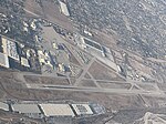 | two miles (3.2 km) southeast of downtown San Bernardino, California, in San Bernardino County, California, United States. The airport covers 1,329 acres... 13 KB (1,047 words) - 04:56, 20 March 2024 |
 | north and northeast of San Bernardino and spanning two California counties, the range tops out at 11,503 feet (3,506 m) at San Gorgonio Mountain – the tallest... 43 KB (4,659 words) - 16:10, 22 October 2023 |
 | The San Bernardino Line is a Metrolink line running between Downtown Los Angeles east through the San Gabriel Valley and the Inland Empire to San Bernardino... 21 KB (1,498 words) - 04:13, 21 April 2024 |
census-designated place in the Victor Valley of the Mojave Desert, within San Bernardino County, California. Oak Hills is in the Mojave Desert north of the Cajon Summit... 7 KB (626 words) - 06:37, 20 September 2023 |
 | related to Essex, San Bernardino County, California. Essex is a small unincorporated community in San Bernardino County, California. Essex lies on Old... 8 KB (747 words) - 19:59, 2 November 2023 |
 | 283°W / 34.067; -117.283 The San Bernardino Valley (Spanish: Valle de San Bernardino) is a valley in Southern California located at the south base of... 24 KB (2,240 words) - 06:37, 13 February 2024 |
| The San Bernardino Santa Fe Depot (Metrolink designation San Bernardino–Depot) is a Mission Revival Style passenger rail terminal in San Bernardino, California... 16 KB (1,271 words) - 00:22, 24 April 2024 |
in San Bernardino County, California, passed most recently in 2004. The SBCTA conducts transportation planning, construction, and operation in San Bernardino... 17 KB (1,558 words) - 02:25, 24 April 2024 |
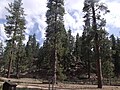 | The San Bernardino National Forest is a United States National Forest in Southern California encompassing 823,816 acres (3,333.87 km2) of which 677,982... 10 KB (913 words) - 21:53, 18 June 2023 |
 | town in San Bernardino County, California, United States. Located in the Calico Mountains of the Mojave Desert region of Southern California, it was founded... 20 KB (1,962 words) - 11:20, 29 March 2024 |
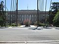
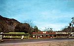
San Bernardino, California, was named in 1810. San Bernardino's earliest known inhabitants were Serrano Indians (Spanish for "people of the mountains")... 67 KB (9,469 words) - 04:21, 22 February 2024 |
 | place situated between the San Bernardino Mountains and the Little San Bernardino Mountains in San Bernardino County, California, United States. Oak Glen... 11 KB (1,210 words) - 06:37, 20 September 2023 |
 | formerly Soda Springs, is an unincorporated community in San Bernardino County, California, United States, within the boundaries of the Mojave National... 12 KB (1,062 words) - 04:58, 26 April 2024 |
 | Yukaipa't) is a city located 10 miles (16 km) east of San Bernardino, in San Bernardino County, California, United States. The population was 54,542 at the... 23 KB (2,154 words) - 15:04, 29 March 2024 |
attempted bombing, occurred at the Inland Regional Center in San Bernardino, California, United States. The perpetrators, Syed Rizwan Farook and Tashfeen... 229 KB (19,429 words) - 05:46, 1 April 2024 |
Lake is a lake in the Big Bear Valley of the San Bernardino Mountains, in San Bernardino County, California. It is located southwest of Big Bear Lake reservoir... 6 KB (392 words) - 06:32, 17 October 2023 |
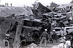 | combination of two separate but related incidents that occurred in San Bernardino, California, United States: a runaway train derailment on May 12, 1989; and... 27 KB (3,725 words) - 03:32, 7 January 2024 |
 | of San Bernardino County, California, United States, with Los Angeles County to its west and Orange County to its south in the Southern California region... 34 KB (2,713 words) - 02:15, 4 April 2024 |
 | San Bernardino, and Palm Springs before crossing into the state of Arizona. In the Greater Los Angeles area, it is known as the Santa Monica and San Bernardino... 69 KB (4,234 words) - 16:44, 27 April 2024 |
six miles (9.7 km) north of Baker, in the Mojave Desert of San Bernardino County, California. When the railroad ceased to operate in 1940, the town was... 3 KB (74 words) - 10:58, 3 March 2024 |
 | southwestern corner of San Bernardino County, California, United States. The city borders Los Angeles County on its northwest side, Orange County to its south and... 35 KB (3,240 words) - 06:15, 8 March 2024 |
 | (datum) is at the summit of Mount San Bernardino, in the San Bernardino Mountains, in San Bernardino County, California. It is at an elevation of over 10... 4 KB (372 words) - 13:02, 6 January 2024 |
 | above sea level, and is located just north of the San Gabriel, San Bernardino, and Little San Bernardino Mountains. The term "High Desert" is commonly used... 18 KB (1,400 words) - 01:29, 8 April 2024 |