 | Satellite geodesy is geodesy by means of artificial satellites—the measurement of the form and dimensions of Earth, the location of objects on its surface... 21 KB (2,338 words) - 20:20, 13 April 2024 |
 | Geodesy is the science of measuring and representing the geometry, gravity, and spatial orientation of the Earth in temporally varying 3D. It is called... 37 KB (4,184 words) - 21:12, 12 April 2024 |
 | Space geodesy is geodesy by means of sources external to Earth, mainly artificial satellites (in satellite geodesy) but also quasars (in very-long-baseline... 471 bytes (50 words) - 09:45, 23 May 2022 |
 | problem observing a flying body such as Echo 1 for precise purposes of satellite geodesy, down to a 20° elevation, which corresponds to a distance of 2,900... 11 KB (1,152 words) - 13:54, 24 March 2024 |
 | modeling of the shape of the Earth, and her work on the development of satellite geodesy models, that were later incorporated into the Global Positioning System... 22 KB (2,064 words) - 05:32, 6 April 2024 |
| Figure of the Earth (category Geodesy) In geodesy, the figure of the Earth is the size and shape used to model planet Earth. The kind of figure depends on application, including the precision... 23 KB (2,821 words) - 15:15, 24 April 2024 |
| World Geodetic System (category Geodesy) World Geodetic System (WGS) is a standard used in cartography, geodesy, and satellite navigation including GPS. The current version, WGS 84, defines an... 24 KB (2,809 words) - 05:56, 18 March 2024 |
| Earth ellipsoid (category Geodesy) axes of an Earth ellipsoid, ranging from meridian arcs up to modern satellite geodesy or the analysis and interconnection of continental geodetic networks... 19 KB (2,379 words) - 23:35, 14 April 2024 |
 | Physical geodesy is the study of the physical properties of Earth's gravity and its potential field (the geopotential), with a view to their application... 8 KB (1,708 words) - 17:55, 20 March 2024 |
Geodetic astronomy (redirect from Celestial geodesy) astronomical geodesy (astro-geodesy) is the application of astronomical methods into geodetic networks and other technical projects of geodesy. The most... 4 KB (425 words) - 23:24, 14 January 2024 |
| Bloßfeld, M. (November 2019). "Laser geodetic satellites: a high-accuracy scientific tool". Journal of Geodesy. 93 (11): 2181–2194. Bibcode:2019JGeod..93... 20 KB (1,994 words) - 18:58, 29 September 2023 |
| Geoid (category Geodesy) years in the history of geodesy and geophysics, it has been defined to high precision only since advances in satellite geodesy in the late 20th century... 26 KB (3,056 words) - 23:24, 18 April 2024 |
 | Deployable Camera 2 List of laser ranging satellites Lunar Laser Ranging experiment Balloon satellites Satellite geodesy "NASA - NSSDCA - Spacecraft - Details"... 4 KB (669 words) - 23:07, 11 March 2024 |
 | authors list (link) "Doris-Equipped Satellites". "ITRF2014". itrf.ensg.ign.fr. IGN. G. Seeber: Satellite Geodesy. De Gruyter-Verlag, 2. Auflage (590 p... 4 KB (411 words) - 06:42, 8 August 2023 |
 | Geodetic control network (category Surveying and geodesy markers) techniques of control surveying, such as terrestrial surveying or satellite geodesy. It is also known as a geodetic network, reference network, control... 7 KB (717 words) - 17:27, 31 December 2023 |
Global Positioning System (redirect from Global positional satellite) (December 2019). "Multi-GNSS orbit determination using satellite laser ranging". Journal of Geodesy. 93 (12): 2447–2463. Bibcode:2019JGeod..93.2447B. doi:10... 177 KB (18,448 words) - 02:11, 2 May 2024 |
The Indian Regional Navigation Satellite System (IRNSS), with an operational name of NavIC (acronym for Navigation with Indian Constellation; also, nāvik... 54 KB (4,433 words) - 15:22, 25 April 2024 |
| Geodetic datum (redirect from Datum (geodesy)) crucial to any technology or technique based on spatial location, including geodesy, navigation, surveying, geographic information systems, remote sensing... 29 KB (3,073 words) - 16:06, 31 December 2023 |
| which rely on physical survey marks that deteriorate over time. Altitude Geodesy Sea Level Datum of 1929 Topographic elevation Topography Reference ellipsoid... 7 KB (732 words) - 16:18, 31 January 2024 |
2017, the satellites are fully useful for precise positioning and geodesy with a limited usability in navigation. Twenty-two further satellites with Full... 107 KB (10,609 words) - 09:46, 23 March 2024 |
 | integrating and disseminating information across regions troublesome. As satellite geodesy and remote sensing technology reached high precision and were made... 13 KB (1,613 words) - 06:32, 16 April 2024 |
| The history of geodesy (/dʒiːˈɒdɪsi/) began during antiquity and ultimately blossomed during the Age of Enlightenment. Many early conceptions of the Earth... 100 KB (12,812 words) - 19:30, 26 March 2024 |
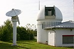
 | Geodetic Observatory Wettzell (category Geodesy organizations) Institute for Applied Geodesy for optical observation and orbit determination of geodetic Earth satellites. The field of satellite geodesy newly arisen at that... 8 KB (909 words) - 23:10, 3 February 2024 |
independent of some state or calibration parameters. In problems of Satellite Geodesy, the computing load of the HWB (and FKF) method is roughly proportional... 11 KB (1,398 words) - 15:56, 30 October 2023 |
| Geographic coordinate system (category Geodesy) representation Latitude / Longitude Map projection Reference ellipsoid Satellite geodesy Spatial reference system Spatial relations Vertical positions Technologies... 21 KB (2,380 words) - 18:12, 4 April 2024 |
 | Jürgen (2012-05-29). Geodesy. DE GRUYTER. doi:10.1515/9783110250008. ISBN 978-3-11-020718-7. Seeber, Günter (2003-06-19). Satellite Geodesy. Walter de Gruyter... 6 KB (723 words) - 21:15, 27 September 2023 |
 | Ground station (redirect from Satellite earth station) above the local horizon Radio astronomy Radio telescope Satellite geodesy#Satellite tracking Satellite truck SatNOGS Test loop translator "Federal Standard... 13 KB (1,244 words) - 16:52, 16 April 2024 |
| Oceanic and Atmospheric Administration. Altitude Elevation Geodetic datum Geodesy Geoid Mean sea level North American Vertical Datum of 1988 Reference ellipsoid... 4 KB (397 words) - 01:26, 19 November 2023 |
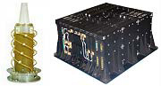
 | research areas are developed in satellite geodesy and geoinformatics. The main topic is the development of satellite laser ranging systems (SLR), both... 21 KB (1,991 words) - 00:48, 6 April 2024 |
Department of Aerospace and Geodesy (ASG) is located in Ottobrunn. It combines the field of aerospace engineering with research in satellite navigation, earth observation... 30 KB (2,035 words) - 23:15, 2 September 2023 |