
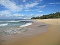
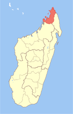
Sava is a region in northern Madagascar. Its capital is Sambava. Until 2009 Sava belonged to Antsiranana Province. The region is situated at the northern...
9 KB (528 words) - 23:03, 22 December 2023
Madagascar, officially the Republic of Madagascar, is an island country comprising the island of Madagascar and numerous smaller peripheral islands. Lying...
217 KB (20,638 words) - 07:52, 7 May 2024
Sambava (category Populated places in Sava Region)
Malagasy: kaominina) at the east coast of northern Madagascar. It is the capital of Sambava District and Sava Region. The population of the commune was 84,039...
8 KB (280 words) - 05:35, 14 February 2023

Vohemar (category Populated places in Sava Region)
coastal city and a municipality in northern Madagascar. It belongs to the district of Iharana, which is a part of Sava Region. It had a population of 22047 in...
6 KB (279 words) - 08:43, 25 June 2023

Humbert Falls (category Sava Region)
Humbert Falls is a waterfall in the Marojejy National Park in North-Eastern Madagascar. It is situated approximately 800m from Camp Mantella and 4.3 km from...
1 KB (60 words) - 15:12, 18 January 2020
Sava Region, Madagascar. It has a length of 31.4 kilometres (19.5 mi) and links Nosiarina, Bemanevika and Tanambao Daoud. List of roads in Madagascar...
616 bytes (45 words) - 16:21, 12 May 2024

Antalaha (category Populated places in Sava Region)
is an urban municipality in northern Madagascar. It belongs to the district of Antalaha, which is a part of Sava Region. The population of Antalaha was...
9 KB (320 words) - 01:35, 11 February 2024

Fanambana Bridge (category Sava Region geography stubs)
Fanambana River on Route nationale 5a between Vohemar and Sambava in Sava, Madagascar. This bridge is a cable-stayed bridge with fan system, completed in...
658 bytes (67 words) - 21:22, 3 November 2017
Vohemar Airport (category Sava Region)
Vohemar Airport (IATA: VOH, ICAO: FMNV) is an airport in Vohemar, Sava Region, Madagascar. "VOH Airport Information". World Aero Data. DAFIF. Archived from...
2 KB (64 words) - 04:45, 30 January 2024

(RN 3b) is a secondary highway in Madagascar of 106 km, running from Sambava to Andapa. It crosses the region of Sava. (west to east) Andapa Tanambo Ambatobarika...
805 bytes (58 words) - 06:23, 16 February 2024

The Madagascar lowland forests or Madagascar humid forests are a tropical moist broadleaf forest ecoregion found on the eastern coast of the island of...
11 KB (994 words) - 21:45, 20 November 2023

is a secondary highway in Madagascar of 406 km, running from Ambilobe to Antalaha. It crosses the regions of Diana and Sava. The section from Ambilobe...
2 KB (165 words) - 04:13, 17 March 2024

Sambava Airport (category Sava Region)
Sambava Airport is an airport in Sambava, Sava Region, Madagascar (IATA: SVB, ICAO: FMNS). "SVB Airport Information". World Aero Data. DAFIF. Archived...
2 KB (46 words) - 04:43, 30 January 2024

The Madagascar ericoid thickets is a montane shrubland ecoregion, found at higher altitudes on Madagascar's four major mountains. The ecoregion covers...
7 KB (666 words) - 06:41, 15 April 2023

Loky River (category Rivers of Sava Region)
in northern Madagascar. It drains in the north-eastern coast, into the Indian Ocean and forms the natural border between Diana and Sava Region. It is...
2 KB (64 words) - 16:05, 21 October 2023
world. NCEP is a global initiative, currently active in Bolivia, Laos, Madagascar, Mexico, Myanmar, Peru, Rwanda, the United States, the Solomon Islands...
8 KB (971 words) - 23:30, 29 May 2022
Diana Region (redirect from Diana, Madagascar)
Diana is a region in Madagascar at the northern part of the island. It borders the regions of Sava to the southeast and Sofia to the southwest. It covers...
10 KB (548 words) - 18:52, 30 January 2024
Anjanaharibe-Sud Special Reserve (category Sava Region)
Sites in Madagascar in 2008, as an extension of the rainforests of the Atsinanana. The special reserve of Anjanahraibe-Sud is located in the Sava Region...
4 KB (416 words) - 02:11, 20 November 2022
Masoala is a village in Madagascar, in the Antalaha District of the Sava Region of the Antsiranana Province, on the South coast of the Masoala Peninsula...
358 bytes (48 words) - 14:11, 11 July 2015
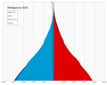
Demographic features of the population of Madagascar include population density, ethnicity, education level, health of the populace, economic status, religious...
37 KB (2,282 words) - 14:24, 7 April 2024

Masoala National Park (category Sava Region)
National Park, in northeast Madagascar, is the largest of the island's protected areas. Most of the park is situated in Sava Region and a part in Analanjirofo...
5 KB (474 words) - 20:29, 20 January 2024
Ampisikina (category Populated places in Sava Region)
commune (Malagasy: kaominina) in northern Madagascar. It belongs to the district of Vohemar, which is a part of Sava Region. The population of the commune...
5 KB (143 words) - 18:04, 11 March 2017

Andampy (category Populated places in Sava Region)
is a rural municipality in northern Madagascar. It belongs to the district of Antalaha, which is a part of Sava Region. The municipality has a populations...
5 KB (88 words) - 15:12, 2 May 2023
Antananambo (category Populated places in Sava Region)
commune (Malagasy: kaominina) in northern Madagascar. It belongs to the district of Antalaha, which is a part of Sava Region. According to 2001 census the...
5 KB (105 words) - 21:42, 11 March 2017

Fanambana (category Populated places in Sava Region)
commune (Malagasy: kaominina) in northern Madagascar. It belongs to the district of Vohemar, which is a part of Sava Region. The town is situated at the Fanambana...
5 KB (166 words) - 12:35, 29 January 2021
Sahantaha (category Populated places in Sava Region)
is a rural municipality in northern Madagascar. It belongs to the district of Antalaha, which is a part of Sava Region. The municipality has a populations...
5 KB (74 words) - 15:13, 2 May 2023

Wikimedia Commons has media related to Rivers of Madagascar. This is a list of streams and rivers in Madagascar Contents: Top 0–9 A B C D E F G H I J K L M...
2 KB (177 words) - 17:14, 22 November 2022
Antombana (category Populated places in Sava Region)
commune (Malagasy: kaominina) in northern Madagascar. It belongs to the district of Antalaha, which is a part of Sava Region. According to 2001 census the...
5 KB (101 words) - 21:57, 11 March 2017
Matsohely (category Populated places in Sava Region)
commune (Malagasy: kaominina) in northern Madagascar. It belongs to the district of Andapa, which is a part of Sava Region. According to a 2001 census, the...
5 KB (113 words) - 15:44, 25 March 2017
Antsirabato Airport (category Sava Region)
Antsirabato Airport is an airport in Antalaha, Madagascar (IATA: ANM, ICAO: FMNH). This airport can be accessed by the National road 53. It is in a distance...
2 KB (55 words) - 05:50, 15 February 2023