
The Saxon Shore Way is a long-distance footpath in England. It starts at Gravesend, Kent, and traces the coast of South-East England as it was in Roman...
7 KB (689 words) - 22:31, 7 January 2024

The Saxon Shore (Latin: litus Saxonicum) was a military command of the Late Roman Empire, consisting of a series of fortifications on both sides of the...
19 KB (2,294 words) - 00:03, 20 March 2024
Saxon Shore (band), an American post-rock band The Saxon Shore, a 1995 novel by Jack Whyte Saxon Shore Way, a modern walkway in Britain Saxon Shore,...
506 bytes (98 words) - 00:37, 13 August 2019

Saxon Shore Way: 163 miles (262 km). Originally opened in 1980, but has since been re-established, and in parts re-routed and extended. Solent Way: 60...
19 KB (2,129 words) - 16:52, 15 May 2024

head of Conyer Creek, which flows into the Swale to the north. The Saxon Shore Way and National Cycle Route 1 pass through the hamlet. Amenities in Conyer...
7 KB (700 words) - 01:52, 31 August 2022
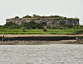
within the parish of Hoo, Kent. The fort can be viewed from along the Saxon Shore Way, accessible from Vicarage Lane in Hoo. Originally designed for two...
3 KB (250 words) - 12:09, 8 January 2022

Capel-le-Ferne, and to its end at Dover, some 8 mi (13 km) away. The Saxon Shore Way starts at Gravesend, Kent and traces the Kent coast as it was in Roman...
60 KB (6,359 words) - 20:20, 15 May 2024
Jevington the E9 route leaves the South Downs Way and follows the 1066 Country Walk and Saxon Shore Way to Dover, from where it returns to France. It...
14 KB (1,725 words) - 18:46, 16 March 2024

Military Canal and the western end of the 1940s sea defence wall. The Saxon Shore Way passes through Pett Level. Pett parish church is dedicated to St Mary...
8 KB (741 words) - 22:29, 8 October 2023

East Sussex (redirect from Combe Valley Way)
South Downs Way; 1066 Country Walk, High Weald Landscape Trail, Saxon Shore Way, Sussex Border Path, Sussex Ouse Valley Way, Vanguard Way, Wealdway and...
38 KB (3,788 words) - 19:19, 27 March 2024
stiles and steps however several high-up views. These walks link to the Saxon Shore Way. Also shorter walks. A leaflet is available from the Visitor Centre...
15 KB (1,966 words) - 17:33, 28 January 2024
recreational walking routes, these being the Saxon Shore Way, the Stour Valley Walk, the Wantsum Walk and the Way of St Augustine. A variant spelling of the...
7 KB (841 words) - 01:20, 9 May 2022

the National Trust and is open to the public; it is traversed by the Saxon Shore Way, the Kent coastal walk. LB&SCR H2 class 4-4-2 no. 421 (later no. B421...
5 KB (639 words) - 08:49, 27 January 2023

follows parts of the South West Coast Path, the Solent Way, the South Downs Way and the Saxon Shore Way paths. The British route itself includes an alternative...
7 KB (711 words) - 21:17, 15 April 2024

information point) in the main car park, along Lower Rainham Road. The Saxon Shore Way (long distance path) leads along the coast through the park, between...
14 KB (1,582 words) - 18:27, 9 May 2024

example, whether the Saxon Shore was defensive or to facilitate the passage of goods. Andrew Pearson suggests that the "Saxon Shore Forts" and other coastal...
170 KB (23,542 words) - 02:35, 9 May 2024
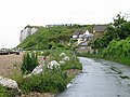
cliffs east of London. A pedestrian promenade north of this has the Saxon Shore Way, part of the round-Kent coastal long-distance walk. Three nearby flights...
2 KB (186 words) - 11:55, 1 September 2022

from Canterbury and Ashford; and the A299, north coast route. The Saxon Shore Way Long distance footpath skirts the coast. There is an airport, now closed...
30 KB (2,316 words) - 03:53, 2 March 2024
Kingsdown has numerous local public footpaths and lies on both the Saxon Shore Way and the White Cliffs Country Trail. The section of National Cycle Route...
7 KB (853 words) - 15:54, 30 May 2023

originally built by the military to provide access, and is passed by the Saxon Shore Way long-distance footpath. Lowry, Bernard (2006). Discovering Fortifications:...
15 KB (1,940 words) - 15:08, 31 December 2023

Saxon raiders had been harassing the eastern and southern shores of Britannia for centuries before, prompting the construction of the Saxon Shore forts...
55 KB (7,012 words) - 06:41, 18 May 2024

ranging from 3 – 6 miles (5 - 9.6 km) long, the walks are linked to the Saxon Shore Way, offering potential routes for long-distance walkers. The lake trail...
5 KB (495 words) - 13:52, 6 May 2023
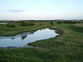
Sittingbourne and Faversham are also located on the marshes. The Saxon Shore Way runs along the coast of the marshes, and onwards to Hastings on the...
5 KB (578 words) - 21:16, 5 May 2024

a recreational resource and include a skateboard park. Part of the Saxon Shore Way footpath runs along the coast here. Swalecliffe Community Day Service...
9 KB (946 words) - 20:20, 21 April 2024
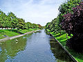
length of the canal, forming part of the longer 163-mile (262 km) Saxon Shore Way. Aside from being historically significant in its own right, the path...
10 KB (905 words) - 15:50, 1 March 2024

a navigable and fortified trade route, used from Roman times. The Saxon Shore Way passes close by the old boundaries, indicating silting over many centuries...
10 KB (1,114 words) - 17:18, 4 February 2024

1897 to 1936. Dover has two long distance footpaths: the Saxon Shore Way and the North Downs Way. The National Trust White Cliffs can be reached by foot...
51 KB (4,960 words) - 00:13, 3 May 2024

drawings by Ralph Steadman; London: Steam Press, 1981 98 copies. The Saxon Shore Way: From Gravesend to Rye, by Sillitoe and Fay Godwin. London: Hutchinson...
21 KB (2,366 words) - 06:11, 15 March 2024
the organisation. This has helped maintain the Pennine Way, the Pilgrims' Way, the Saxon Shore Way, Offa's Dyke, The Ridgeway and many others routes, as...
24 KB (2,496 words) - 13:49, 30 October 2023

Tonbridge along the bank most of the way above Allington. It starts on the Saxon Shore Way at Rochester. The North Downs Way crosses the river using the Medway...
26 KB (2,785 words) - 06:37, 29 January 2024