 | The Schroon River (/ˈskruːn/ SKROON) is a 67.7-mile-long (109.0 km) tributary of the Hudson River in the southern Adirondack Mountains of New York, beginning... 3 KB (232 words) - 18:05, 26 May 2021 |
 | Why schroon lake is called schroon lake ?? The Dutch where here in the 1700's and schroon means in Dutch langauge Clean - beautiful, so tha'ts the reason... 17 KB (1,913 words) - 19:26, 24 April 2024 |
 | Sacandaga River Kunjamuk River Schroon River Trout Brook Minerva Stream The Branch Patterson Brook North Creek Boreas River Indian River Jessup River Miami... 44 KB (3,593 words) - 04:13, 20 January 2024 |
 | takes in the Schroon River at Warrensburg. Further south, the river forms the boundary between Warren and Saratoga Counties. The river then takes in... 123 KB (11,182 words) - 02:03, 25 April 2024 |
 | of U.S. Route 9 (US 9) that largely followed the eastern bank of the Schroon River. The southern terminus of the route was at NY 8 in the town of Horicon... 7 KB (710 words) - 23:17, 12 November 2021 |
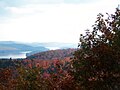 | Schroon Lake is located near Schroon Lake, New York. Fish species present in the lake are lake trout, landlocked salmon, largemouth bass, smallmouth bass... 3 KB (164 words) - 03:26, 8 April 2024 |
 | The East River is a saltwater tidal estuary or strait in New York City. The waterway, which is actually not a river despite its name, connects Upper New... 74 KB (9,218 words) - 10:39, 29 March 2024 |
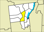 | Warrensburg, New York (category New York (state) populated places on the Hudson River) 8 km2) of it (1.74%) is water. The west town line is the Hudson River. The Schroon River empties into the Hudson by the west town line. As of the census... 20 KB (2,064 words) - 13:14, 19 January 2024 |
 | trek to Ticonderoga at exit 28. The Schroon River resumes north of the exit, and I-87 and US 9 follow the river and its rural valley to the northeast... 100 KB (8,119 words) - 03:52, 26 April 2024 |
 | State Department of Transportation. July 16, 2007. Retrieved May 7, 2008. "Schroon Lake 1804 - 2004". Adirondack Gold Pages. 2008. Retrieved May 7, 2008.... 44 KB (2,266 words) - 12:20, 19 June 2022 |
 | Jersey Palisades or the Hudson River Palisades, are a line of steep cliffs along the west side of the lower Hudson River in Northeastern New Jersey and... 21 KB (2,122 words) - 23:29, 19 November 2023 |
Macomb Mountain stands within the watershed of the Schroon River, which drains into the Hudson River, and into New York Bay. The east and northeast sides... 3 KB (268 words) - 04:34, 13 April 2022 |
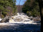
Warrensburg Hydroelectric Dam (category Run-of-the-river power stations) Warrensburg Hydroelectric Dam is a run-of-the-river hydroelectric generation plant located on the Schroon River in Warrensburg, NY. According to the National... 2 KB (180 words) - 10:03, 26 April 2024 |
 | 3 km2), or 1.74%, is water. Two branches of the Schroon River, a south-flowing tributary of the Hudson River, arise in North Hudson. The Adirondack Northway... 14 KB (832 words) - 06:28, 30 July 2023 |
Scarborough River - Maine Schoharie Creek - New York Schoolcraft River - Minnesota Schroon River - New York Schuylkill River - Pennsylvania Scioto River - Ohio... 18 KB (1,558 words) - 05:08, 18 July 2022 |
 | eastward through the towns of Thurman and Warrensburg, following the Schroon River to an intersection with U.S. Route 9 (US 9) in the hamlet of Warrensburg... 11 KB (1,179 words) - 11:06, 24 August 2023 |
Retrieved May 17, 2017. USGS Water Data Support Team. "USGS 0131690208 SCHROON RIVER BELOW BRANT LAKE OUTLET". National Water Information System: Web Interface... 3 KB (165 words) - 18:56, 28 October 2020 |
 | State Route 74 (New York–Vermont) (redirect from Ticonderoga and Schroon Turnpike) Adirondack Northway. It then meets Stowell Road just before crossing the Schroon River. The highway meets a few local road intersections just south of Goosebury... 36 KB (3,470 words) - 20:25, 12 April 2024 |
 | is in the water / is actively submerged"] is a waterfall on the Mohawk River shared by the city of Cohoes and the town of Waterford, New York. Cohoes... 7 KB (789 words) - 17:15, 10 April 2024 |
 | Warrensburg Junior - Senior High School Address 103 Schroon River Rd Warrensburg , New York United States Coordinates 43°29′53.4″N 73°45′47.4″W / 43... 2 KB (53 words) - 07:41, 25 February 2024 |
the Schroon River, the Hudson River, and into New York Bay. The south side of Grace Peak drains into West Mill Brook, thence into the Schroon River. Grace... 4 KB (300 words) - 22:30, 21 September 2022 |
of South Dix drains into West Mill Brook, thence into the Schroon River, the Hudson River, and into New York Bay. The west side of South Dix drains into... 3 KB (279 words) - 13:45, 13 March 2024 |
 | 2012 915P 0.11 0.18 I-87 in Warrensburg I-87 exit 24 Warren CR 10 (Schroon River Road) in Warrensburg 915Q US 20 SH 78-3 in Duanesburg NY 7 I-88 exit... 124 KB (1,299 words) - 21:15, 20 February 2024 |
 | commercial core on the north side of the Schroon River and historic industrial core on the south side of the river of the hamlet of Warrensburgh. It includes... 3 KB (266 words) - 22:33, 6 August 2023 |
 | the West Inlet of Elk Lake, thence into The Branch of the Schroon River, the Hudson River, and into New York Bay. The south and east sides of Nippletop... 3 KB (241 words) - 03:02, 3 March 2022 |
Benjamin Pond Democratic-Republican 8th March 4, 1811 – March 3, 1813 Schroon ? Theodore L. Poole Republican 27th March 4, 1895 – March 3, 1897 Syracuse... 336 KB (303 words) - 23:06, 16 April 2024 |
 | American Engineering Record (HAER) No. NY-146, "Emerson Sawmill, Scroon River, River Street, Warrensburg, Warren County, NY", 17 photos, 4 data pages, 1 photo... 3 KB (204 words) - 22:19, 2 April 2024 |
 | U.S. Route 9 in New York (category Hudson River) replaced the Great Northern Road, which ran from the Hudson River near Glen Falls through Schroon Lake and Elizabethtown to the Canadian border; this road... 105 KB (8,861 words) - 04:44, 24 April 2024 |
 | into the East Inlet of Elk Lake, and into The Branch of the Schroon River, the Hudson River, and into New York Bay. Hough Peak is within the Dix Mountain... 3 KB (201 words) - 03:50, 15 April 2022 |
Statistical Area. Warrensburg is located on U.S. Route 9, on the Schroon River, east of the Hudson River, and west of Interstate 87 (The Northway). The CDP is entirely... 8 KB (650 words) - 11:57, 14 August 2023 |