
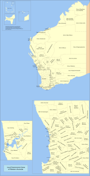
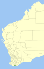
Perth. The Shire covers an area of 2,018 square kilometres (779 sq mi), and its seat of government is the town of Quairading. Quairading was initially...
9 KB (573 words) - 18:01, 11 January 2024

Quairading is a Western Australian town located in the Wheatbelt region. It is the seat of government for the Shire of Quairading. The town was named...
13 KB (1,334 words) - 11:51, 28 February 2024

Dangin, Western Australia (category Shire of Quairading)
Juliet (2003). The Big Q: A history of Quairading and its surrounding districts. Quairading: Shire of Quairading. pp. 86–89. "The Dangin Gate Case". The...
8 KB (944 words) - 04:06, 7 January 2024

Wheatbelt (Western Australia) (redirect from Wheatbelt region of Western Australia)
Shire of Quairading Shire of Tammin Shire of Toodyay Shire of Wyalkatchem Shire of York Central Coast, comprising: Shire of Chittering Shire of Dandaragan...
18 KB (1,526 words) - 04:20, 1 May 2024
plus the Shire of Peppermint Grove Town – predominantly inner urban, plus the Town of Port Hedland The Shire of Christmas Island and the Shire of Cocos (Keeling)...
60 KB (1,458 words) - 21:17, 6 March 2024
Badjaling, Western Australia (category Shire of Quairading)
Lake of Quairading is actually at Badjaling, with the main road, Bruce Rock–Quairading Road, crossing it. Badjaling Nature Reserve Australian Bureau of Statistics...
3 KB (248 words) - 05:17, 14 August 2023

Banksia cuneata (redirect from Quairading Banksia)
the shire logo. There is a park named Cuneata Park in the town of Quairading. "SPRAT profile - Banksia cuneata — Matchstick Banksia, Quairading Banksia"...
40 KB (4,580 words) - 18:52, 27 December 2023
Wheatbelt. Retrieved 3 April 2021. Emergency services were called to the mid-west town of Quairading to find the 100-year-old Quairading School well alight....
4 KB (169 words) - 08:22, 25 February 2023

Pantapin, Western Australia (category Shire of Quairading)
the Wheatbelt region of Western Australia. The town originated as a railway siding that was planned in 1912 as part of the Quairading to Bruce Rock line...
2 KB (122 words) - 05:34, 11 February 2023

Westrail P class (category Diesel locomotives of Western Australia)
The P class are a class of diesel locomotives built by A Goninan & Co, Bassendean for Westrail between 1989 and 1991. In 1988, Westrail placed an order...
7 KB (229 words) - 00:44, 14 August 2023

The Shire of Capel is a local government area in the South West region of Western Australia, taking in the land between the cities of Bunbury and Busselton...
10 KB (781 words) - 13:04, 18 September 2023

Narembeen, Nungarin, Quairading, Tammin, Trayning, Westonia, Wyalkatchem and Yilgarn and the Mid West Shire of Wiluna from the seat of Durack, while it would...
11 KB (655 words) - 18:01, 28 April 2024

council committed to a proposal to amalgamate with the shires of York, Cunderdin and Quairading. Planning for the merger reached an advanced stage via the...
8 KB (474 words) - 12:51, 3 July 2023
The Shire of Denmark is a local government area in the Great Southern region of Western Australia, about 55 kilometres (34 mi) west of Albany and about...
9 KB (717 words) - 11:41, 20 February 2023

The Shire of Corrigin is a local government area in the Wheatbelt region of Western Australia, about 230 kilometres (143 mi) east of the state capital...
10 KB (753 words) - 06:57, 25 February 2023

The Shire of Broomehill-Tambellup is a local government area in the Great Southern region of Western Australia, 320 kilometres (200 mi) south-southeast...
9 KB (767 words) - 22:04, 12 November 2023

The Shire of Christmas Island is a local government area encompassing the Australian external territory of Christmas Island. Under the Christmas Island...
7 KB (657 words) - 01:57, 2 November 2023

Yoting, Western Australia (category Shire of Quairading)
located between Quairading and Bruce Rock in the Wheatbelt region of Western Australia. It was originally a station on the Quairading to Bruce Rock railway...
2 KB (184 words) - 05:34, 11 February 2023
Balkuling, Western Australia (category Shire of Quairading)
192 km east of Perth, Western Australia along the Quairading-York Road situated in the Wheatbelt region of Western Australia. The townsite of Balkuling...
2 KB (199 words) - 05:35, 11 February 2023

The Shire of Ashburton is one of the four local government areas in the Pilbara region of Western Australia, covering an area of 105,647 square kilometres...
12 KB (947 words) - 08:21, 23 February 2023

The Shire of Dumbleyung is a local government area in the Wheatbelt region of Western Australia, about 40 kilometres (25 mi) east of Wagin and about 275...
8 KB (598 words) - 23:15, 2 February 2024

The Shire of Cocos (Keeling) Islands is a local government area which manages local affairs on the Australian external territory of Cocos (Keeling) Islands...
7 KB (613 words) - 14:41, 3 March 2024
the south of Darkan within the Shire of West Arthur. The locality is situated at an average elevation of 251 metres above the sea level. As of the 2021...
1 KB (93 words) - 08:44, 6 May 2024

The Shire of East Pilbara is one of the four local government areas in the Pilbara region of Western Australia. With an area of 372,571 square kilometres...
7 KB (529 words) - 18:49, 10 February 2024

The Shire of Wongan–Ballidu is a local government area in the Wheatbelt region of Western Australia, about 180 kilometres (112 mi) NNE of Perth, the state...
7 KB (498 words) - 09:10, 25 February 2023
This is a list of heritage sites on the State Register of Heritage Places within the Shire of York in Western Australia but not within the York town site...
2 KB (64 words) - 13:27, 28 April 2022

Cervantes, Western Australia (category Shire of Dandaragan)
north-north-west of the state capital, Perth, in the Shire of Dandaragan local government area. At the 2016 census, Cervantes had a population of 527. The town...
2 KB (215 words) - 11:36, 6 October 2023

Pootenup Popanyinning Pormpuraaw Porongurup Primbee Pyree →Q← Quaama Quairading Qualeup Quambone Queanbeyan Quandialla Quigup Quindalup Quindanning Quirindi...
56 KB (1,989 words) - 02:16, 11 May 2024
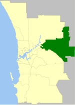
The Shire of Mundaring is a local government area in eastern metropolitan Perth, the capital of Western Australia. The Shire covers an area of 645 square...
13 KB (894 words) - 07:36, 28 February 2024

The Shire of Murray is a local government area of Western Australia. It has an area of 1,710.1 square kilometres (660.3 sq mi) and is located in the Peel...
14 KB (1,135 words) - 13:15, 8 December 2023