 | Sierra County (/siˈɛrə/ ) is a county located in the U.S. state of California. As of the 2020 census, the population was 3,236, making it California's... 49 KB (2,872 words) - 17:13, 29 April 2024 |
Trail, California, United States Sierra County, California Sierra County, New Mexico Sierra Foothills AVA, an American Viticultural Area in California Sierra... 4 KB (570 words) - 22:54, 29 April 2024 |
 | Yuba Pass is a mountain pass on State Route 49 in Sierra County in the U.S. state of California. The pass lies at an elevation of 6,710 ft (2,050 m) about... 2 KB (145 words) - 17:05, 13 October 2023 |
Sierra County is the name of two counties in the United States: Sierra County, California Sierra County, New Mexico This disambiguation page lists articles... 155 bytes (53 words) - 03:29, 30 December 2019 |
 | The Sierra Madre (Spanish for "mother range") is a mountain range in southwestern California. It forms the southernmost part of the California Coast Ranges... 7 KB (730 words) - 04:29, 15 November 2023 |
 | Sierra City (Sierra, Spanish for "mountain range") is a census-designated place in Sierra County, California, United States. The elevation of Sierra City... 13 KB (1,267 words) - 03:34, 26 April 2024 |
 | Inyo County (/ˈɪnjoʊ/ ) is a county in the eastern central part of the U.S. state of California, located between the Sierra Nevada and the state of Nevada... 65 KB (3,632 words) - 15:14, 23 April 2024 |
 | since the California gold rush, and before numbering was known by several names including El Camino Sierra. The route of US 395 in California is split... 53 KB (4,632 words) - 12:52, 21 January 2024 |
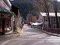
| Downieville is a census-designated place in and the county seat of Sierra County, California, United States. Downieville is on the North Fork of the Yuba... 25 KB (1,953 words) - 08:13, 2 May 2024 |
 | list of the National Register of Historic Places listings in Sierra County, California. This is intended to be a complete list of the properties and... 7 KB (285 words) - 01:40, 14 January 2024 |
 | Sierra Madre (Spanish for "mother range") is a city in Los Angeles County, California, whose population was 10,917 at the 2010 U.S. Census, up from 10... 66 KB (6,623 words) - 17:28, 1 January 2024 |
 | The U.S. state of California is divided into 58 counties. The state was first divided into 27 counties on February 18, 1850. These were further sub-divided... 25 KB (861 words) - 00:29, 21 March 2024 |
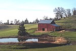
 | Loyalton is a city in Sierra County, California, United States. At the 2020 census, the population was 740, reflecting a decline of 29 from the 769 counted... 18 KB (1,632 words) - 03:50, 17 January 2024 |
 | County (/ˈpluːməs/ ) is a county in the Sierra Nevada of the U.S. state of California. As of the 2020 census, the population was 19,790. The county seat... 75 KB (3,279 words) - 15:19, 23 April 2024 |
 | the southern Sierra. The Sierra Nevada has played an important role in the history of California and the United States. The California Gold Rush occurred... 70 KB (7,049 words) - 10:52, 28 April 2024 |
Sierra College is a public community college in Rocklin, California. It is part of the Sierra Joint Community College District, a district that covers... 7 KB (577 words) - 03:48, 26 April 2024 |
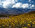
 | Sierra Valley is a large mountain valley located east of the crest of California's Sierra Nevada mountain range in Plumas and Sierra Counties, north of... 4 KB (441 words) - 15:21, 26 February 2024 |
 | Monte Cristo was a mining camp in Sierra County in the U.S. state of California, near California State Route 49 and Downieville. Monte Cristo can be reached... 6 KB (615 words) - 06:40, 6 February 2024 |
 | entirely in the Sierra Nevada, from the historic Gold Country in the western foothills to the High Sierra in the east. El Dorado County's population has... 61 KB (3,425 words) - 17:12, 29 April 2024 |
includes properties and districts on the California Historical Landmarks listings for Sierra County, in eastern California. Click the "Map of all coordinates"... 2 KB (93 words) - 00:01, 7 October 2023 |
 | Area code 530 (category Sierra County, California) Sacramento), Shasta Cascade, and the northern Sierra Nevada. It comprises all or sections of the following counties: Alpine, Butte, Colusa, El Dorado, Glenn... 17 KB (772 words) - 02:32, 9 April 2024 |
 | Alta Sierra (Spanish for "Upper Range") is a census-designated place (CDP) in Nevada County, California, United States. The population was 6,911 at the... 14 KB (1,179 words) - 15:06, 23 April 2024 |
 | Alpine County is a county in the eastern part of the U.S. state of California located within the Sierra Nevada on the state border with Nevada. As of the... 44 KB (2,596 words) - 15:12, 23 April 2024 |
 | The county seat is Auburn. Placer County is included in the Greater Sacramento metropolitan area. It is in both the Sacramento Valley and Sierra Nevada... 58 KB (2,475 words) - 17:13, 29 April 2024 |
 | Mariposa County. State Route 49 then continues northward through the counties of Tuolumne, Calaveras, Amador, El Dorado, Placer, Nevada, Yuba, Sierra, and... 36 KB (2,930 words) - 12:41, 26 April 2024 |
 | it the fourth-least populous county in California. The county seat is Bridgeport. The county is located east of the Sierra Nevada between Yosemite National... 48 KB (2,026 words) - 15:18, 23 April 2024 |
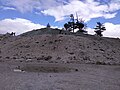 | Crystal Peak is a mountain in Sierra County, California. It is located on the south end of the Bald Mountain Range, 3 mi (4.8 km) northeast of Sardine... 2 KB (180 words) - 21:07, 9 July 2023 |
 | Amador County (/ˈæmədɔːr/ ) is a county located in the U.S. state of California, in the Sierra Nevada. As of the 2020 census, the population was 40,474... 49 KB (2,429 words) - 15:12, 23 April 2024 |
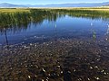
 | Independence Lake is a natural glacial lake in the Sierra Nevada of California. At an elevation of 6,949 feet (2,118 m) in the upper reaches of the Truckee... 16 KB (1,601 words) - 03:50, 6 January 2024 |
 | Nevada County (/nɪˈvædə/ niv-AD-ə) is a county located in the U.S. state of California, in the Sierra Nevada. As of the 2020 census, its population was... 59 KB (3,751 words) - 15:19, 23 April 2024 |