 | Silver Bow County is a county in the U.S. state of Montana. As of the 2020 census, the population was 35,133. Its county seat is Butte. In 1977, the city... 14 KB (995 words) - 00:31, 26 April 2024 |
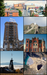 | is a consolidated city-county and the county seat of Silver Bow County, Montana, United States. In 1977, the city and county governments consolidated... 134 KB (12,255 words) - 07:21, 18 April 2024 |
 | Walkerville is a town in Silver Bow County, Montana, United States, that is an enclave of the consolidated city-county of Butte. The population was 639... 14 KB (1,383 words) - 17:50, 29 April 2024 |
(secondary coordinates) There are at least 25 named mountains in Silver Bow County, Montana. Beals Hill, 45°58′09″N 112°52′33″W / 45.96917°N 112.87583°W... 5 KB (1,171 words) - 17:18, 20 March 2022 |
 | County and Butte with Silver Bow County. The portion of Yellowstone National Park that lies within Montana was not part of any county until 1978, when part... 24 KB (565 words) - 23:15, 25 April 2024 |
 | Silver Bow Creek is a 26-mile-long (42 km) headwater stream of the Clark Fork (river) originating within the city limits of Butte, Montana, from the confluence... 7 KB (905 words) - 11:27, 13 November 2023 |
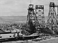 | in Butte, Montana that closed operations in 1947 and was eventually consumed by the Berkeley Pit, a vast open-pit mine. Originally a silver mine, it was... 6 KB (703 words) - 02:31, 10 June 2023 |
 | Clark Fork River (category Bodies of water of Silver Bow County, Montana) miles (66,900 km2). In its upper 20 miles (32 km) in Montana near Butte, it is known as Silver Bow Creek. Interstate 90 follows much of the upper course... 19 KB (1,826 words) - 21:47, 12 August 2023 |
 | Berkeley Pit (category Geography of Silver Bow County, Montana) 1987. It is one of sixteen Superfund sites in Montana, and the final unrestored section of the Silver Bow Creek/Butte Area site. In 1995, a flock of migrating... 20 KB (2,000 words) - 19:51, 12 April 2024 |
 | Bert Mooney Airport (redirect from Silver Bow County Airport) LID: BTM) is a public airport three miles southeast of Butte, in Silver Bow County, Montana, United States. It is owned by the Bert Mooney Airport Authority... 7 KB (520 words) - 00:37, 5 April 2024 |
coordinates) There are at least 14 named lakes and reservoirs in Silver Bow County, Montana. Emerald Lake, 45°45′17″N 112°28′24″W / 45.75472°N 112.47333°W... 3 KB (669 words) - 04:20, 8 April 2022 |
 | Lodge–Silver Bow county border, I-90 intersects MT 1. Fairmont Hot Springs Resort, accessible via S-441, is the first exit in Silver Bow County on I-90... 37 KB (2,100 words) - 13:05, 16 April 2024 |
 | Litchfield County, Connecticut; Butte, Silver Bow County, Montana; at Frisco, Beaver County, Utah; and from the Joplin district, Jasper County, Missouri... 5 KB (358 words) - 20:10, 8 April 2024 |
Montana Technological University, popularly known as Montana Tech, is a public university in Butte, Montana. Founded in 1900 as the Montana State School... 29 KB (2,862 words) - 21:02, 1 April 2024 |
 | The Butte, Montana labor riots of 1914 were a series of violent clashes between copper miners at Butte, Montana. The opposing factions were the miners... 15 KB (2,364 words) - 14:46, 14 March 2023 |
Silver Bow is a neighborhood in Butte, Montana, United States. It lies near the interchange of Interstate 15 and Interstate 90, near Rocker. It is the... 1 KB (127 words) - 07:15, 18 September 2023 |
 | Homestake Pass (redirect from Homestake, Montana) Mountains of Montana in the United States. It sits on the Continental Divide on the border between Jefferson County and Silver Bow County, six miles south-southeast... 4 KB (414 words) - 03:07, 12 January 2024 |
and Deer Lodge County, Montana Butte and Silver Bow County, Montana Columbus and Muscogee County, Georgia Cusseta and Chattahoochee County, Georgia Georgetown... 51 KB (4,820 words) - 11:55, 22 April 2024 |
 | Mountains of Montana in the United States. It sits on the Continental Divide in Silver Bow County, Montana, 10 miles (16 km) south of Butte, Montana, in Beaverhead-Deerlodge... 2 KB (266 words) - 14:39, 10 April 2023 |
 | "Reporter's notebook: Visiting depths of Butte's Continental Pit". Montana Standard. Butte, Montana. 31 May 2015. Retrieved 27 February 2020. "Eagle". Lundin Mining... 15 KB (397 words) - 15:18, 5 April 2024 |
 | Interstate 115 (redirect from Interstate 115 (Montana)) was funded by the federal government. The entire route is in Butte, Silver Bow County. I-115 was constructed and included in the Interstate Highway System... 7 KB (564 words) - 19:46, 23 January 2024 |
 | Speculator Mine disaster (category Silver Bow County, Montana) fire consumed their oxygen; a total of 168 miners were killed. The Butte, Montana copper mines were at full wartime production to support the US in World... 7 KB (834 words) - 19:11, 7 November 2022 |
 | Melrose is a small community in Silver Bow County, Montana, United States. It is 34 miles (55 km) south of Butte and about 30 miles (48 km) north of Dillon... 2 KB (164 words) - 12:32, 28 August 2023 |
Gregson is a ghost town in northwestern Silver Bow and southeastern Deer Lodge counities in Montana, United States. A post office operated in Gregson... 1 KB (93 words) - 05:45, 14 November 2023 |
Grace is an unincorporated community in Silver Bow County, in the U.S. state of Montana. Grace contained a post office between 1882 and 1926. The community... 1 KB (100 words) - 05:45, 14 November 2023 |
Divide is a rural community in Silver Bow County, Montana, United States. It is administered as part of Butte. The community's name is based on its proximity... 6 KB (325 words) - 13:39, 4 February 2024 |
King and Queen Hill (category Mountains of Silver Bow County, Montana) King and Queen Hill is a summit in Silver Bow County, Montana, in the United States. With an elevation of 7,861 feet (2,396 m), King and Queen Hill is... 690 bytes (81 words) - 14:12, 29 June 2023 |
 | list of the National Register of Historic Places listings in Silver Bow County, Montana. It is intended to be a complete list of the properties and districts... 10 KB (272 words) - 00:05, 20 April 2024 |
 | The Silver Bow County Poor Farm Hospital at 3040 Continental Dr. in Butte, Montana was built in 1902. It includes design by architect Charles S. Haire... 1 KB (94 words) - 05:28, 9 August 2023 |
Mount Humbug (category Mountains of Silver Bow County, Montana) Mount Humbug is a summit in Silver Bow County, Montana, in the United States. With an elevation of 8,219 feet (2,505 m), Mount Humbug is the 811th highest... 662 bytes (73 words) - 13:19, 23 March 2023 |