 | Siskiyou County (/ˈsɪskjuː/ SISK-yoo) is a county located in the northwestern part of the U.S. state of California. As of the 2020 census, the population... 55 KB (2,582 words) - 15:27, 23 April 2024 |
 | Yreka (/waɪˈriːkə/ wy-REE-kə) is the county seat of Siskiyou County, California, United States, near the Shasta River; the city has an area of about 10... 47 KB (4,361 words) - 04:52, 17 April 2024 |
unincorporated communities counties, and other recognized places in the U.S. state of California. Information on the number and names of counties in which the place... 71 KB (77 words) - 00:51, 20 January 2024 |
 | Weed is a city in Siskiyou County, California, United States. As of the 2020 Census, the city had a total population of 2,862, down from 2,967 in 2010... 37 KB (3,775 words) - 14:29, 23 April 2024 |
 | The Siskiyou Mountains are a coastal subrange of the Klamath Mountains, and located in northwestern California and southwestern Oregon in the United States... 30 KB (2,807 words) - 07:44, 8 February 2024 |
 | Mount Shasta (also known as Mount Shasta City) is a city in Siskiyou County, California, United States, at about 3,600 feet (1,100 m) above sea level... 27 KB (2,434 words) - 14:43, 26 March 2024 |
 | Wilderness Press. ISBN 0-89997-404-X. History - 800 Black Butte Rd Wikimedia Commons has media related to Black Butte (Siskiyou County, California).... 6 KB (466 words) - 16:27, 12 January 2024 |
 | districts listed on the National Register of Historic Places in the 58 counties of California, including 145 designated as National Historic Landmarks. The following... 18 KB (381 words) - 20:53, 8 April 2024 |
 | The Rogue River–Siskiyou National Forest is a United States National Forest in the U.S. states of Oregon and California. The formerly separate Rogue River... 13 KB (951 words) - 02:29, 9 January 2024 |
 | Dorris is a city in Siskiyou County, California, United States. Its population is 860 as of the 2020 census, down from 939 from the 2010 census. The town... 16 KB (1,405 words) - 01:26, 28 February 2024 |
Oregon and California Siskiyou County, California Siskiyou Trail, an old Native American and pioneer trail connecting Oregon and California Siskiyou Summit... 628 bytes (107 words) - 02:41, 20 June 2023 |
 | list of the National Register of Historic Places listings in Siskiyou County, California. This is intended to be a complete list of the properties and... 10 KB (310 words) - 09:48, 6 March 2022 |
 | Jefferson (proposed Pacific state) (category History of Siskiyou County, California) said that the Oregon counties of Curry, Josephine, Jackson, and Klamath should join with the California counties of Del Norte, Siskiyou, and Modoc to form... 33 KB (3,318 words) - 00:06, 5 March 2024 |
Scott Valley Unified School District Seiad Elementary School District Siskiyou Union High School District Weed Union Elementary School District Willow... 58 KB (5,117 words) - 22:19, 18 December 2023 |
 | Dunsmuir is a city in Siskiyou County, northern California. It is on the upper Sacramento River. Its population is 1,707 as of the 2020 census, up from... 40 KB (4,196 words) - 23:50, 16 February 2024 |
 | Tulelake (/ˈtuːlileɪk/ TOO-lee-layk) is a city in northeastern Siskiyou County, California, United States. The town is named after nearby Tule Lake. Its... 20 KB (1,525 words) - 14:52, 26 March 2024 |
 | now Siskiyou County in the east. It is the only county in California to be disestablished. The original county seat was Trinidad, on the county's southwestern... 9 KB (850 words) - 15:16, 23 April 2024 |
 | Mount Shasta (redirect from Mount Shasta (California)) potentially active volcano at the southern end of the Cascade Range in Siskiyou County, California. At an elevation of 14,179 ft (4,322 m), it is the second-highest... 42 KB (3,960 words) - 14:48, 27 April 2024 |
 | median in California after I-8's In‑Ko‑Pah grade. In Siskiyou County, I-5 passes through Dunsmuir before intersecting SR 89 near Lake Siskiyou and entering... 129 KB (6,844 words) - 19:14, 17 April 2024 |
 | Siskiyou County Airport (IATA: SIY, ICAO: KSIY) is a public airport located three miles (4.8 km) northeast of Montague, serving Siskiyou County, California... 6 KB (755 words) - 08:22, 11 February 2024 |
 | Area code 530 (category Siskiyou County, California) following counties: Alpine, Butte, Colusa, El Dorado, Glenn, Humboldt, Lassen, Modoc, Mono, Nevada, Placer, Plumas, Shasta, Sierra, Siskiyou, Sutter, Tehama... 17 KB (772 words) - 02:32, 9 April 2024 |
 | Klamath Mountains (category Mountain ranges of Siskiyou County, California) California; 9,029 feet (2,752 m)) Thompson Peak (Trinity and Siskiyou County, California; 8,994 feet (2,741 m)) Mount Hilton (Trinity and Siskiyou County... 25 KB (2,295 words) - 00:18, 24 February 2024 |
 | (Karuk: athithúf-vuunupma) is a census-designated place (CDP) in Siskiyou County, California, United States. Its population is 905 as of the 2020 census,... 22 KB (1,730 words) - 21:44, 23 March 2024 |
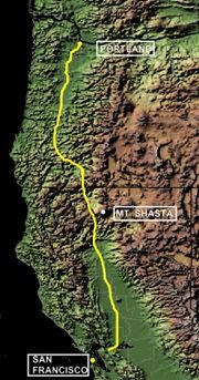 | The Siskiyou Trail stretched from California's Central Valley to Oregon's Willamette Valley; modern-day Interstate 5 follows this pioneer path. Originally... 8 KB (890 words) - 18:26, 18 December 2023 |
Shasta, Siskiyou, and Tehama counties. County Route A1, more commonly known as Route of the Olympic Torch, is a 35.3-mile (56.8 km) county route in Lassen... 33 KB (1,680 words) - 21:03, 28 March 2024 |
 | Macdoel is a census-designated place (CDP) in Siskiyou County, California, United States. Macdoel is located on U.S. Route 97 approximately halfway between... 11 KB (959 words) - 05:40, 12 July 2023 |
 | Fort Jones is a city in the Scott Valley area of Siskiyou County, California, United States. Like many of the communities that surround Mount Shasta,... 24 KB (2,305 words) - 14:49, 26 March 2024 |
 | mountain located in the Siskiyou Mountains of Northern California in the United States. The summit, located in Siskiyou County, is at an elevation of 6... 5 KB (217 words) - 02:48, 31 October 2023 |
 | McCloud is a small town and census-designated place (CDP) in Siskiyou County, California, United States. Its population is 945 as of the 2020 census,... 18 KB (1,460 words) - 15:58, 30 March 2024 |
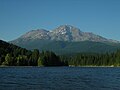 | Lake Siskiyou is a reservoir formed by Box Canyon Dam on the Sacramento River, in far northern California, near the town of Mt. Shasta, California. It... 3 KB (191 words) - 18:36, 22 August 2022 |