 | Southeast (SE or S.E.) is the southeastern quadrant of Washington, D.C., the capital of the United States, and is located south of East Capitol Street... 9 KB (643 words) - 00:32, 28 February 2024 |
 | Washington, D.C., located in Southeast D.C. Navy Yard, situated along the Anacostia Riverfront south of Capitol Hill, takes its name from Washington Navy... 14 KB (1,189 words) - 13:54, 24 April 2024 |
| Washington, D.C. SE – Southeast, Washington, D.C. NW – Northwest, Washington, D.C. Wikimedia Commons has media related to Northeast, Washington, D.C.... 7 KB (539 words) - 02:31, 14 March 2024 |
| Southwest, Washington, D.C. SE – Southeast, Washington, D.C. NE – Northeast, Washington, D.C. "Map of the Wards of the District of Columbia" (PDF). DC.gov.... 9 KB (613 words) - 06:33, 29 February 2024 |
| Southwest (SW or S.W.) is the southwestern quadrant of Washington, D.C., the capital of the United States, and is located south of the National Mall and... 25 KB (2,542 words) - 00:35, 30 December 2023 |
 | Capitol Hill (redirect from Capitol Hill, Washington, D C) Capitol Hill is a neighborhood in Washington, D.C., located in both Northeast D.C. and Southeast D.C.. Dominated by the United States Capitol, which sits... 26 KB (2,277 words) - 04:25, 13 March 2024 |
 | Washington Highlands is a residential neighborhood in Southeast Washington, D.C., in the United States. It lies within Ward 8. Washington Highlands is... 33 KB (4,074 words) - 06:44, 24 November 2022 |
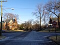 | Hillcrest is a residential neighborhood in the southeast quadrant of Washington, D.C., United States. Hillcrest is located on the District-Maryland line... 6 KB (555 words) - 13:49, 7 August 2023 |
 | statistical areas Northwest, Washington, D.C. Northeast, Washington, D.C. Southeast, Washington, D.C. Southwest, Washington, D.C. The District of Columbia... 27 KB (2,094 words) - 12:43, 8 April 2024 |
 | small residential and industrial neighborhood in Southeast Washington, D.C. Woodland lies in Washington's Ward 8, among the poorest and least developed of... 16 KB (1,632 words) - 19:50, 22 April 2024 |
 | Marine Barracks, Washington, D.C. is located at the corner of 8th and I streets, Southeast in Washington, D.C. Established in 1801, it is a National Historic... 19 KB (1,681 words) - 05:06, 28 April 2024 |
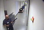 | the Naval Sea Systems Command (NAVSEA) inside the Washington Navy Yard in southeast Washington, D.C. The attack took place in the Navy Yard's Building... 49 KB (4,536 words) - 01:02, 29 April 2024 |
The streets and highways of Washington, D.C., form the core of the surface transportation infrastructure in Washington, D.C., the federal capital of the... 30 KB (3,197 words) - 17:04, 13 April 2024 |
 | The Washington Navy Yard (WNY) is a ceremonial and administrative center for the United States Navy, located in Washington, D.C. It is the oldest shore... 45 KB (4,887 words) - 20:31, 1 April 2024 |
 | Twining is a neighborhood in Southeast Washington, D.C., near the eastern bank of the Anacostia River. It is bounded by Minnesota Avenue NE to the northeast... 3 KB (111 words) - 14:17, 3 May 2022 |
 | Douglass is a residential neighborhood in Southeast Washington, D.C., on the eastern side of St. Elizabeths Hospital, on the border of the Congress Heights... 4 KB (225 words) - 18:26, 23 January 2023 |
 | Washington, D.C., formally the District of Columbia and commonly called Washington or D.C., is the capital city and federal district of the United States... 290 KB (24,184 words) - 20:28, 26 April 2024 |
 | Good Hope is a residential neighborhood in southeast Washington, D.C., near Anacostia. The neighborhood is generally middle class and is dominated by... 10 KB (1,017 words) - 15:12, 18 April 2024 |
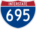 | (I-695), also known as the Southeast Freeway, is a two-mile-long (3.2 km) auxiliary Interstate Highway in Washington, D.C.. It travels from an interchange... 17 KB (1,488 words) - 04:37, 11 April 2024 |
 | Garfield Heights is a residential neighborhood in Southeast Washington, D.C., bordering Prince George's County, Maryland. Garfield Heights contains both... 4 KB (179 words) - 16:47, 7 February 2022 |
 | Anacostia (redirect from Anacostia, Washington, D.C.) Anacostia /ænəˈkɒstiə/ is a historic neighborhood in Southeast Washington, D.C. Its downtown is located at the intersection of Good Hope Road and Martin... 22 KB (2,304 words) - 04:09, 7 February 2024 |
 | Capitol View is a neighborhood located in southeast Washington, D.C., in the United States. It is bounded by East Capitol Street to the north, Central... 24 KB (2,701 words) - 16:27, 18 April 2024 |
 | Avenue begins at the intersection of South Capitol Street in Southeast, Washington, D.C., and Indian Head Highway on the Maryland side. It runs for approximately... 4 KB (204 words) - 00:31, 23 July 2021 |
Trinity Washington University is a private Catholic university in Washington, D.C. The university was founded as Trinity College by the Sisters of Notre... 21 KB (2,143 words) - 01:36, 19 April 2024 |
 | a working class and middle class residential neighborhood in southeast Washington, D.C., United States. It is bounded by Interstate 295, Pennsylvania... 15 KB (1,629 words) - 17:12, 7 April 2024 |
 | Kent is a neighborhood in Northwest Washington, D.C. in the United States, bounded by Loughboro Road to the north, MacArthur Boulevard to the southwest... 5 KB (508 words) - 06:52, 6 January 2024 |
 | Marshall Heights is a residential neighborhood in Southeast Washington, D.C. It is bounded by East Capitol Street, Central Avenue SE, Southern Avenue... 67 KB (8,288 words) - 15:45, 17 October 2023 |
 | a Washington Metro station in Washington, D.C., on the Green Line. The station is located in the Navy Yard/Near Southeast neighborhood of Southeast, with... 10 KB (830 words) - 06:27, 4 February 2024 |
 | Stadium–Armory station (redirect from Stadium–Armory station (Washington, D.C.)) Stadium–Armory station is a Washington Metro station in Southeast, Washington, D.C. It is located at the border of the Barney Circle and Kingman Park neighborhoods... 12 KB (1,103 words) - 02:18, 15 February 2024 |
 | Fort Davis is a residential neighborhood located in southeast Washington, D.C., on the border between the District of Columbia and Maryland. It is bounded... 3 KB (172 words) - 14:06, 15 July 2021 |