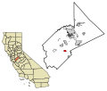
 | Stanislaus County (/ˈstænɪslɔː(s)/ ; Spanish: Condado de Estanislao) is a county located in the San Joaquin Valley of the U.S. state of California. As... 66 KB (3,298 words) - 16:05, 8 May 2024 |
California State University, Stanislaus (Stanislaus State, Stan State) is a public university in Turlock, Stanislaus County, California. It is part of... 23 KB (1,835 words) - 07:22, 17 April 2024 |
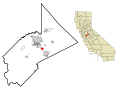
 | Turlock is a city in Stanislaus County, California, United States. Its population was 72,740 at the 2020 United States Census, making it the second-largest... 49 KB (4,325 words) - 16:57, 12 April 2024 |
 | The Stanislaus County Fair, located in Turlock, California, opens every year in mid-July. It is the largest event in Stanislaus County. For 10 days, more... 26 KB (3,842 words) - 10:10, 23 April 2024 |
 | The Stanislaus River is a tributary of the San Joaquin River in north-central California in the United States. The main stem of the river is 96 miles (154 km)... 120 KB (13,706 words) - 06:50, 15 January 2024 |
 | Patterson is a city in Stanislaus County, California, United States, located off Interstate 5. It is 27 miles (43 km) southeast of Tracy and is part of... 22 KB (2,045 words) - 06:51, 19 December 2023 |
This is a list of school districts in California. California school districts are of several varieties, usually a Unified district, which includes all... 58 KB (5,117 words) - 03:41, 9 May 2024 |
 | Stanislaus County is defined and authorized under the California Constitution and law as a general law county. Much of the Government of California is... 7 KB (769 words) - 04:37, 20 January 2023 |
 | Riverbank is a city in Stanislaus County, California, United States. The population was 24,623 at the 2020 census, up from 15,826 at the 2000 census.... 17 KB (1,362 words) - 00:45, 1 April 2024 |
This list includes incorporated cities in Stanislaus County, California as well as census-designated places according to population over 5,000 people... 2 KB (185 words) - 20:20, 9 February 2024 |
Joaquin, Stanislaus, and Tulare counties. County Route J1 (CR J1) is a county highway in San Benito and Fresno counties in the U.S. state of California. It... 117 KB (4,843 words) - 16:47, 19 December 2023 |
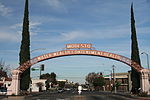
 | Spanish pronunciation: [moˈðesto]) is the county seat and largest city of Stanislaus County, California, United States. With a population of 218,069... 99 KB (9,451 words) - 01:42, 9 May 2024 |
 | Oakdale is a city in the San Joaquin Valley and Stanislaus County, California. It is part of the Modesto Metropolitan Statistical Area. Oakdale goes by... 24 KB (2,295 words) - 01:30, 9 May 2024 |
properties and districts listed on the California Historical Landmark listing in Stanislaus County, California. Click the "Map of all coordinates" link... 3 KB (105 words) - 03:08, 28 July 2021 |
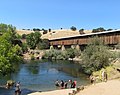
 | Knights Ferry is an unincorporated historic community in Stanislaus County, California, United States. Nestled in the foothills of the Sierra Nevada,... 12 KB (1,094 words) - 19:36, 25 February 2024 |
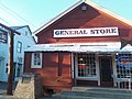
 | La Grange is a small unincorporated community in rural Stanislaus County, California. Its altitude is 249 feet (76 m). As of 2020 it has a population... 6 KB (649 words) - 22:04, 26 July 2023 |
 | Stanislaus National Forest is a U.S. National Forest which manages 898,099 acres (1,403.3 sq mi; 3,634.5 km2) of land in four counties in the Sierra Nevada... 5 KB (427 words) - 20:18, 24 December 2023 |
 | (Spanish for "Exit") is a census-designated place (CDP) in Stanislaus County, California, in the United States. As of the 2010 census, the CDP population... 19 KB (1,885 words) - 21:34, 10 February 2024 |
 | Peninsula and the Silicon Valley), and SR 140 at the Stanislaus county line. I-5 crosses the California Aqueduct for the third time between SR 152 and SR 33... 129 KB (6,844 words) - 15:21, 6 May 2024 |
 | Area codes 209 and 350 (category Stanislaus County, California) Woodbridge Ripon South Woodbridge Stockton Taft Mosswood Tracy Victor Stanislaus County Bystrom Ceres Del Rio Denair East Oakdale Empire Grayson Hickman Hughson... 12 KB (640 words) - 16:11, 8 May 2024 |
 | Yosemite. Just past Knights Ferry, SR 108 crosses from Stanislaus County into Tuolumne County, and the road changes from two lanes to four-lane separated... 14 KB (1,103 words) - 00:22, 17 December 2023 |
 | Ceres is a city in Stanislaus County, California. Its population was 49,302 at the 2020 U.S. Census, up from 45,417 at the 2010 U.S. Census. It is part... 19 KB (1,769 words) - 16:30, 16 March 2024 |
 | Crows Landing is a census-designated place (CDP) in Stanislaus County, California. Crows Landing is about 20 miles (32 km) southwest of Modesto. Crows... 8 KB (751 words) - 04:59, 17 August 2023 |
 | enforcement duties within the boundaries of Stanislaus County, California. As of the 2020 United States census, the county was inhabited by just under 552,880... 9 KB (401 words) - 19:50, 20 March 2022 |
 | Route 99 (SR 99) is a north–south state highway in the U.S. state of California, stretching almost the entire length of the Central Valley. From its southern... 74 KB (3,572 words) - 17:51, 12 March 2024 |
 | 2, 2023. Map: "Stanislaus National Forest, California," U.S. Forest Service, 1979. Wikimedia Commons has media related to California State Route 120... 22 KB (1,550 words) - 06:14, 26 February 2024 |
is a mountain summit along the divide of the Diablo Range in Stanislaus County, California. It rises to an elevation of 2,251 / 686 meters. Mustang Peak... 1 KB (147 words) - 12:01, 12 January 2019 |
 | parts of 18 California counties: Butte, Colusa, Glenn, Fresno, Kern, Kings, Madera, Merced, Placer, San Joaquin, Sacramento, Shasta, Stanislaus, Sutter,... 54 KB (5,667 words) - 13:14, 19 April 2024 |
 | Stanislaus Regional Transit Authority, branded as The S, is a public transportation bus system serving Modesto, California and surrounding Stanislaus... 23 KB (1,068 words) - 02:31, 14 April 2024 |
 | Keyes is a census-designated place (CDP) in Stanislaus County, California, United States. The population was 5,601 at the 2010 census, up from 4,575 at... 13 KB (1,269 words) - 05:54, 11 July 2023 |