The State Plane Coordinate System (SPCS) is a set of 125 geographic zones or coordinate systems designed for specific regions of the United States. Each... 7 KB (965 words) - 15:06, 26 February 2024 |
 | standardized coordinate systems were created during the 20th century, such as the Universal Transverse Mercator, State Plane Coordinate System, and British... 21 KB (2,802 words) - 02:18, 12 April 2024 |
 | (UTM) and national systems such as the British National Grid, and State Plane Coordinate System (SPCS). Engineering coordinate system (or local, custom)... 15 KB (1,546 words) - 22:10, 9 April 2024 |
 | In mathematics, a spherical coordinate system is a coordinate system for three-dimensional space where the position of a given point in space is specified... 42 KB (6,282 words) - 13:02, 18 April 2024 |
 | In geometry, a Cartesian coordinate system (UK: /kɑːrˈtiːzjən/, US: /kɑːrˈtiːʒən/) in a plane is a coordinate system that specifies each point uniquely... 40 KB (5,303 words) - 11:14, 16 April 2024 |
 | Local tangent plane coordinates (LTP), also known as local ellipsoidal system, local geodetic coordinate system, or local vertical, local horizontal coordinates... 6 KB (700 words) - 21:15, 27 September 2023 |
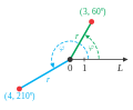 | In mathematics, the polar coordinate system is a two-dimensional coordinate system in which each point on a plane is determined by a distance from a reference... 47 KB (6,214 words) - 02:28, 5 April 2024 |
 | Lambert conformal conic projection (redirect from Lambert coordinate system) aeronautical charts, portions of the State Plane Coordinate System, and many national and regional mapping systems. It is one of seven projections introduced... 10 KB (1,117 words) - 21:54, 11 April 2024 |
 | orbital plane and the planet's equatorial plane. The coordinate system defined that uses the orbital plane as the xy{\displaystyle xy} plane is known... 4 KB (387 words) - 04:27, 5 March 2023 |
 | (x, y) plane and primary (x-axis) direction, such as an axis of rotation. Each coordinate system is named after its choice of fundamental plane. The following... 28 KB (3,840 words) - 03:55, 7 April 2024 |
 | Earth-fixed coordinate system (acronym ECEF), also known as the geocentric coordinate system, is a cartesian spatial reference system that represents... 9 KB (904 words) - 13:39, 7 January 2024 |
Vertical and horizontal (redirect from Horizontal plane) In the context of a 1-dimensional orthogonal Cartesian coordinate system on a Euclidean plane, to say that a line is horizontal or vertical, an initial... 17 KB (2,135 words) - 20:45, 8 December 2023 |
 | United States customary units (redirect from United States Customary System) 1⁄8 in (3 mm) per mile – but it affects the definition of the State Plane Coordinate Systems (SPCSs), which can stretch over hundreds of miles. The NAD27... 48 KB (4,289 words) - 13:21, 1 April 2024 |
 | National Geodetic Survey Concerning Units of Measure for the State Plane Coordinate System of 1983. Minimum Standard Detail Requirements For ALTA/NSPS... 35 KB (3,538 words) - 17:51, 10 April 2024 |
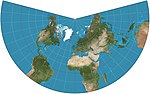
 | days, having been replaced by conformal projections in the State Plane Coordinate System. The American polyconic projection can be thought of as "rolling"... 3 KB (384 words) - 07:17, 23 November 2023 |
Community Standards State Plane Coordinate System St. Paul's Convent School, a secondary school in Hong Kong Soldier Plate Carrier System, a U.S. Army bulletproof... 487 bytes (67 words) - 23:00, 30 October 2022 |
 | significant for mapping, or when the state plane coordinate system (SPCS) is used in the US, because the origin of the system may be hundreds of thousands of... 50 KB (4,481 words) - 18:26, 4 April 2024 |
 | Mile (section Grid system) use. All State Plane Coordinate Systems are defined in metres, and 42 of the 50 states only use the metre-based State Plane Coordinate Systems. However... 76 KB (6,895 words) - 16:28, 8 April 2024 |
 | the rotated coordinate system. In other words, the circle is the locus of points that represent the state of stress on individual planes at all their... 44 KB (6,024 words) - 07:47, 11 December 2023 |
 | Earth-centered inertial (category Astronomical coordinate systems) Earth-centered inertial (ECI) coordinate frames have their origins at the center of mass of Earth and are fixed with respect to the stars. "I" in "ECI"... 8 KB (943 words) - 17:00, 5 September 2023 |
 | United States Geological Survey (redirect from National Water Information System) Land Survey System, and cartesian coordinates in both the State Plane Coordinate System and the Universal Transverse Mercator coordinate system. Other specialty... 34 KB (3,664 words) - 17:46, 1 April 2024 |
| United States National Grid (category Geographic coordinate systems) of the 20th century, State Plane Coordinate Systems (SPCS) brought the simplicity and convenience of Cartesian coordinates to state-level areas, providing... 54 KB (6,255 words) - 06:23, 28 September 2023 |
 | Invariant (mathematics) (redirect from Coordinate system invariant) principal invariants of tensors do not change with rotation of the coordinate system (see Invariants of tensors). The singular values of a matrix are invariant... 23 KB (2,726 words) - 17:54, 23 March 2024 |
 | Azimuth (category Horizontal coordinate system) lit. 'the directions') is the angular measurement in a spherical coordinate system which represents the horizontal angle from a cardinal direction, most... 14 KB (1,705 words) - 08:13, 27 March 2024 |
A Network Coordinate System (NC system) is a system for predicting characteristics such as the latency or bandwidth of connections between nodes in a... 19 KB (2,237 words) - 16:56, 12 March 2024 |
 | Geodesy (section Coordinate systems in the plane) and mapping, two general types of coordinate systems in the plane are in use: Plano-polar, with points in the plane defined by their distance, s, from... 37 KB (4,174 words) - 21:12, 12 April 2024 |
 | numbers, also known as coordinate vectors. Special cases are called the real line R1, the real coordinate plane R2, and the real coordinate three-dimensional... 31 KB (4,099 words) - 13:58, 12 February 2024 |
 | Zodiac (category Astronomical coordinate systems) It is a feature of the ecliptic coordinate system – a celestial coordinate system centered upon the ecliptic (the plane of the Earth's orbit and the Sun's... 64 KB (6,482 words) - 11:52, 18 April 2024 |
 | triangulation based on the metric system (NAD83) was not released until 1986. Since that time, the State Plane Coordinate Systems (SPCSs) established by the... 6 KB (846 words) - 17:10, 24 November 2023 |
 | replacing them with the international versions, particularly with State Plane Coordinate Systems. The choice of unit for surveying purposes is based on the unit... 17 KB (1,540 words) - 08:17, 12 February 2024 |