 | The Stikine Region /stəˈkiːn/[citation needed] is an unincorporated area in northwestern British Columbia, Canada. It is the only area in the province... 22 KB (1,445 words) - 06:38, 22 February 2024 |
 | The Stikine River (/stɪˈkiːn/ stick-EEN) is a major river in northern British Columbia (BC), Canada and southeastern Alaska in the United States. It drains... 84 KB (9,585 words) - 20:04, 26 February 2024 |
 | municipal-type services. The remote settlement of Dease Lake, formerly in the Stikine Region, was added to the regional district on December 1, 2007. Thornhill is... 16 KB (538 words) - 22:23, 1 April 2023 |
Columbia Kitimat-Stikine A, British Columbia Kitimat-Stikine B, British Columbia Kitimat-Stikine C (Part 1), British Columbia Kitimat-Stikine C (Part 2), British... 9 KB (821 words) - 21:03, 4 February 2023 |
incorporated municipalities. The Stikine Region—not to be confused with the Stikine Country or the Kitimat-Stikine Regional District—provides services... 6 KB (513 words) - 16:33, 30 April 2023 |
 | counts three times as much as the vote of Metchosin's appointee. The Stikine Region is not officially per se a regional district but is rather an unincorporated... 15 KB (928 words) - 02:08, 26 November 2023 |
 | Stickeen Territories (redirect from Stikine Territory) Alaska boundary dispute Fort Stikine North-Western Territory Stikine Country Stikine Gold Rush Stikine Region Stikine River "British Columbia: From the... 5 KB (337 words) - 18:14, 18 November 2023 |
which, starting at Prince George, went northwest to Hazelton, along the Stikine River, by Atlin, Teslin and Tagish Lakes, and from Whitehorse, Yukon, to... 49 KB (4,665 words) - 15:22, 23 March 2024 |
Stikine District may refer to any of the following: the Stikine Country, aka the Stikine District, a geographic region of the Canadian province of British... 509 bytes (100 words) - 21:31, 22 August 2021 |
 | the regional districts of Fraser Valley, Squamish–Lillooet, and Kitimat–Stikine. Home to just under 1 million people, the British Columbia Interior's 14... 23 KB (2,123 words) - 05:10, 15 August 2023 |
 | Districts; on its north the boundary with the southern edge of the remote Stikine Region is separated from the Bulkley–Nechako Regional District by the 56th... 16 KB (588 words) - 19:05, 22 January 2024 |
The Stikine Gold Rush was a minor but important gold rush in the Stikine Country of northwestern British Columbia, Canada. The rush's discoverer was Alexander... 3 KB (376 words) - 16:12, 21 April 2024 |
the Stikine Country, aka the Stikine District, a geographic region of the Canadian province of British Columbia, roughly equivalent to the Stikine Mining... 2 KB (351 words) - 15:27, 9 January 2016 |
 | basin of the Stikine River and its tributaries. The term Stikine–Iskut (alone or in various combination forms "District", "Country", "Region") is also fairly... 7 KB (887 words) - 23:33, 5 December 2023 |
 | The Stikine Icecap (sometimes referred to as the Stikine Icefield) is a large icefield straddled on the Alaska–British Columbia boundary in the Alaska... 3 KB (289 words) - 06:32, 6 January 2024 |
| administrative subdivision of the province that consists of a geographic region with specific boundaries and governmental authority. As of January 2020... 6 KB (424 words) - 00:00, 19 July 2022 |
earthquake.usgs.gov. Retrieved 2017-12-25. "M 6.1 - Vancouver Island, Canada region". earthquake.usgs.gov. Retrieved 2018-01-02. "M 6.2 - Haida Gwaii, Canada"... 14 KB (489 words) - 19:58, 13 April 2024 |
Lower Post (category Stikine Country) Lower Post is an aboriginal community in the Stikine Region of northern British Columbia, Canada, located on Highway 97, the Alaska Highway, approximately... 4 KB (423 words) - 16:42, 22 April 2024 |
 | (192,115.90) British Columbia Regional District of Nanaimo (2,038.01) Stikine Region (118,663.10) Manitoba Division No. 11 (571.06) Division No. 23 (242... 7 KB (186 words) - 20:46, 2 June 2022 |
Telegraph Creek (redirect from Stikine River Indian Reserve No. 7) Columbia at the confluence of the Stikine River and Telegraph Creek. The only permanent settlement on the Stikine River, it is home to approximately... 11 KB (857 words) - 01:57, 13 April 2024 |
 | northern and northwestern flanks are in Tatshenshini-Alsek Park, in Stikine Region, British Columbia, making it the second highest peak in British Columbia... 3 KB (145 words) - 07:47, 18 November 2023 |
Fort Stikine was a fur trade post and fortification in what is now the Alaska Panhandle, at the site of the present-day of Wrangell, Alaska. Originally... 24 KB (3,275 words) - 04:23, 14 September 2023 |
 | mi), the largest regional district in British Columbia in area. (The Stikine Region is larger, but is not a regional district.) The total population reported... 30 KB (2,278 words) - 19:11, 22 January 2024 |
 | Columbia. It is the only U.S. state capital which borders another country. Stikine Region, British Columbia – northeast, east Tongass National Forest (part) Admiralty... 92 KB (7,991 words) - 15:31, 18 April 2024 |
List of historic places in northern and central British Columbia Interior (redirect from List of historic places in the Stikine Region) Regional District, Fraser-Fort George Regional District, Peace River Country, and Stikine Country. (references appear in the table above as external links)... 7 KB (59 words) - 15:14, 29 October 2022 |
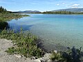 | formerly Boya Lake Provincial Park, is a provincial park located in the Stikine Region of British Columbia, Canada. The park located 120 km north-by-northwest... 2 KB (117 words) - 17:38, 20 January 2024 |
 | Alaska – southeast Hoonah-Angoon Census Area, Alaska – south, west Stikine Region, British Columbia – northwest, east Tongass National Forest (part) Endicott... 9 KB (694 words) - 15:05, 28 March 2024 |
 | present-day Wrangell which was established to forestall encroachment on the Stikine region by the Hudson's Bay Company.[citation needed] Zarembo Island mineral... 5 KB (303 words) - 22:36, 8 July 2023 |
 | Chilcotin Mountains Stawamus Chief Tantalus Upper Lillooet Yalakom Stikine Region Atlin/Áa Tlein Téix'i Dall River Old Growth Denetiah Dune Za Keyih Horneline... 10 KB (1,151 words) - 15:47, 11 February 2024 |
 | Chilcotin Mountains Stawamus Chief Tantalus Upper Lillooet Yalakom Stikine Region Atlin/Áa Tlein Téix'i Dall River Old Growth Denetiah Dune Za Keyih Horneline... 7 KB (613 words) - 15:54, 6 February 2024 |