 | Zimbabwe has a centralised government and is divided into eight provinces and two cities with provincial status, for administrative purposes. Each province... 5 KB (372 words) - 03:30, 19 February 2024 |
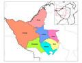
| constituent political entities of Zimbabwe. Zimbabwe currently has ten provinces, two of which are cities with provincial status. Zimbabwe is a unitary state, and... 8 KB (361 words) - 15:00, 28 April 2024 |
in Zimbabwe hit 55.3% in March 2024. Although fractional denominations exist, the ZiG has no formal subdivisions. Cents are used by the Zimbabwe Stock... 15 KB (1,106 words) - 09:26, 13 May 2024 |
 | The Republic of Zimbabwe is broken down into 10 administrative provinces, which are divided into 64 districts and 1,970 wards. Bulawayo Harare Chitungwiza... 4 KB (103 words) - 12:19, 9 September 2023 |
| Districts of Zimbabwe are divided into 1,970 municipal wards as of 2023. The wards based on the 2008 delimitation are found at List of wards of Zimbabwe (2008)... 9 KB (1,163 words) - 21:52, 2 November 2023 |
ISO 3166-2:ZW (category Provinces of Zimbabwe) codes for the names of the principal subdivisions (e.g., provinces or states) of all countries coded in ISO 3166-1. Currently for Zimbabwe, ISO 3166-2 codes... 2 KB (148 words) - 13:24, 27 December 2023 |
 | Mashonaland (category Subdivisions of Zimbabwe) Mashonaland is a region in northeastern Zimbabwe. It is home to nearly half of the population of Zimbabwe. The majority of the Mashonaland people are from the... 6 KB (706 words) - 14:53, 3 May 2024 |
 | Township (redirect from Township (Zimbabwe)) barrios are subdivisions and function as municipalities. In Vietnam, a commune-level town (thị trấn) is similar to a township; it is a subdivision of a rural... 16 KB (1,772 words) - 19:18, 13 May 2024 |
 | Matabeleland (category Subdivisions of Zimbabwe) south-west of Zimbabwe, between the Limpopo and Zambezi rivers and are further separated from Midlands by the Shangani River in central Zimbabwe. The region... 22 KB (2,444 words) - 12:49, 2 May 2024 |
 | semi-autonomous regions, each under the administration of an elected Regional Council. A presidential decree of 12 November 2008 officially instigated the change... 3 KB (316 words) - 07:29, 20 May 2022 |
first-level and second-level country subdivisions. The flags of country subdivisions exhibit a wide variety of regional influences and local histories... 40 KB (1,057 words) - 10:30, 12 May 2024 |
| In the 2008 delimitation the Districts of Zimbabwe were divided into 1,200 municipal wards. The wards based on the 2008 delimitation are listed below... 27 KB (255 words) - 18:02, 3 December 2023 |
 | ISO 3166-2, codes for country subdivisions Capital districts and territories List of terms for country subdivisions List of national capitals serving as... 122 KB (1,735 words) - 06:06, 6 May 2024 |
 | The administrative divisions of Tanzania are controlled by Part I, Article 2.2 of the Constitution of Tanzania. Tanzania is divided into thirty-one regions... 4 KB (354 words) - 17:31, 8 April 2024 |
This is a list of Zimbabwean provinces by Human Development Index as of 2021. "Sub-national HDI - Area Database - Global Data Lab". hdi.globaldatalab.org... 2 KB (25 words) - 12:30, 18 January 2024 |
Mhondoro–Ngezi District (category Districts of Zimbabwe) is a district of the Province Mashonaland West in Zimbabwe. The district has a population of 140,994 inhabitants (2022 census). "Zimbabwe: Administrative... 3 KB (44 words) - 10:53, 28 January 2024 |
 | redrawn and the number of provinces varied across time. Awrajja were subdivisions of provinces, and were the rough equivalent of the current term zones... 8 KB (724 words) - 19:47, 30 December 2023 |
The subdivisions of Kenya have been in place since 2010, replacing the old system. Under the Constitution of 2010 and other reforms to Provincial Administration... 3 KB (259 words) - 13:39, 8 April 2024 |
Seke District (category Zimbabwe geography stubs) Seke District is a district of the Province Mashonaland East in Zimbabwe. "Zimbabwe: Administrative Division". City Population. Retrieved 30 December... 3 KB (49 words) - 12:08, 17 February 2024 |
Murehwa District (category Zimbabwe geography stubs) Murehwa District is a district of the Province Mashonaland East in Zimbabwe. "Zimbabwe: Administrative Division". City Population. Retrieved 30 December... 5 KB (49 words) - 11:26, 17 February 2024 |
 | Umguza District (category Districts of Matabeleland North Province) Umguza is a district in the southern part of Matabeleland North province in Zimbabwe. It was formerly known as Esiphezini District. Umguza District is... 8 KB (576 words) - 12:39, 17 February 2024 |
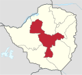 | Midlands Province (redirect from Midlands province, Zimbabwe) Midlands is a province of Zimbabwe. It has an area of 49,166 square kilometres (18,983 sq mi) and a population of 1,811,905 (2022). It is home to various... 8 KB (414 words) - 12:54, 17 February 2024 |
 | the giant of West Africa. A clickable map of Nigeria showing its 36 states and the federal capital territory. "Administrative Subdivisions in Nigeria"... 1 KB (74 words) - 11:27, 30 October 2023 |
Bulilima District (category Districts of Zimbabwe) a district of the Province Matabeleland South in Zimbabwe. It was created in 2003 with the break-up of Bulilimamangwe District. "Zimbabwe: Administrative... 4 KB (70 words) - 12:43, 17 February 2024 |
v t e Subdivisions of Africa Sovereign states Algeria Angola Benin Botswana Burkina Faso Burundi Cameroon Cape Verde Central African Republic Chad Comoros... 3 KB (28 words) - 09:20, 19 February 2024 |
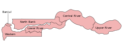 | and one City. The divisions of the Gambia are created by the Independent Electoral Commission in accordance to Article 192 of the National Constitution... 10 KB (923 words) - 03:30, 19 February 2024 |
Muzarabani District (category Zimbabwe geography stubs) flat and situated along the Mocambique-Zimbabwe border in Mashonaland Central province in Zimbabwe. "Zimbabwe: Administrative Division (Provinces and... 3 KB (58 words) - 04:48, 21 February 2024 |
 | Sanyati District (category Zimbabwe articles missing geocoordinate data) Sanyati District is a district of the Province Mashonaland West in Zimbabwe. Sanyati "Zimbabwe: Administrative Division". City Population. Retrieved 30... 4 KB (42 words) - 23:52, 20 February 2024 |
also see political machine. Wards of New York City Wards of New Orleans Wards of Houston Wards of Zimbabwe City of London: Statement as to the Origin... 6 KB (623 words) - 00:26, 2 April 2024 |
This list of schools in the African country of Zimbabwe includes the country's primary and secondary schools. Zimbabwe's tertiary schools are listed on... 17 KB (1,202 words) - 13:06, 12 May 2024 |